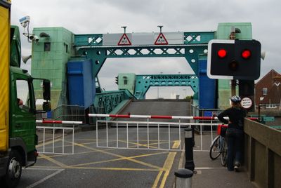
Poole Bridge, Road and bascule bridge in Poole, United Kingdom
Poole Bridge is a twin-leaf bascule bridge that crosses a narrow waterway between the harbour and Holes Bay, linking the town center to Hamworthy. The structure allows large vessels to pass through while traffic on the bridge stops during each opening.
The present structure was built in 1927, replacing an earlier iron swing bridge from 1885, which had itself succeeded an original wooden toll bridge from 1834. Over a century of bridge development served the town's growth as a maritime hub.
The bridge embodies Poole's connection to the sea, a relationship that has shaped the town for centuries. Locals and visitors see daily how it serves maritime traffic and reinforces the area's seafaring character.
The bridge opens regularly for vessel traffic, which interrupts road passage. When planning crossings or visiting the area, it helps to check opening times or use alternative routes if your journey is time-sensitive.
Major renovation work between 2016 and 2018 modernized the bridge's infrastructure to extend its operational lifespan significantly. This substantial investment demonstrates how critical the crossing remains to the town's daily function.
GPS coordinates: 50.71247,-1.99254
Latest update: December 12, 2025 14:21
1 and 3, Church Street
225 m
King Charles Public House (Part)
215 m
Poole School Cross War Memorial
227 m
Hotel Du Vin
180 m
Lamp Post Approximately 2 Metres East Of Number 9
207 m
Lamp Post Approximately 2 Metres South West Of Church Of St James
220 m
7, Thames Street
204 m
Quayside House And Attached Area Railings
200 m
Poole House
195 m
Lamp Post At Junction Of The Two Central Walks In Thames Mews
228 m
Lamp Post Approximately 3 Metres East Of Number 11
203 m
10, St James's Close
237 m
Lamp Post Approximately 5 Metres East Of Number 5
217 m
Lamp Post At Junction With West Street At Entrance To St James's Churchyard
202 m
6, St James's Close
223 m
Kinges Halle
217 m
Lamp Post Approximately 6 Metres East Of Number 8
234 m
Lamp Post Approximately 2 Metres North Of Number 10
235 m
5, Thames Street
206 m
Walls And Railings To South And West Sides Of St James's Churchyard
208 m
10, Thames Street
201 m
Lamp Post 2 Metres East Of Number 1 Thames Mews
219 m
Lamp Post Approximately 5 Metres East Of Number 23
204 m
Lamp Post Approximately 15 Metres East Of Number 2
209 m
Lamp Post At Junction With Thames Street
230 m
West End House And Attached Front Garden Railings And Gate
196 m
8, St James's Close
231 m
23 And 25, Thames Street
192 mVisited this place? Tap the stars to rate it and share your experience / photos with the community! Try now! You can cancel it anytime.
Discover hidden gems everywhere you go!
From secret cafés to breathtaking viewpoints, skip the crowded tourist spots and find places that match your style. Our app makes it easy with voice search, smart filtering, route optimization, and insider tips from travelers worldwide. Download now for the complete mobile experience.
A unique approach to discovering new places❞
— Le Figaro
All the places worth exploring❞
— France Info
A tailor-made excursion in just a few clicks❞
— 20 Minutes