Rainsborough Camp
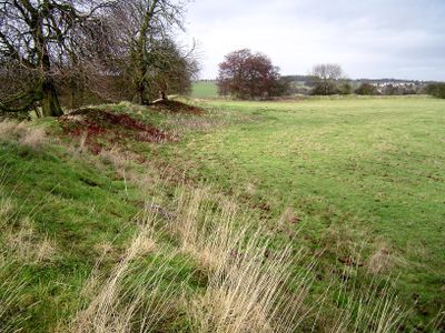
Rainsborough Camp, Iron Age hillfort in Newbottle, England.
Description
Rainsborough Camp is an Iron Age fortified settlement in Newbottle with an oval shape and double rampart system. The inner earthen walls rise several meters above the ground level inside the fort and cover a total area of about 2.6 hectares.
History
The fort was established during the early Iron Age and shows traces of intense settlement before the ramparts were built. Archaeological work uncovered evidence of violent destruction and abandonment of the site during the early Iron Age period.
Culture
The site represents a significant example of Iron Age defensive architecture with its bivallate structure and stone guardrooms at the western entrance.
Practical
The site sits on elevated ground with open sightlines across the surrounding landscape, making it easy to explore. Visitors should wear sturdy footwear since the uneven earthwork and natural contours require solid footing.
Did you know?
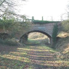
Archaeological digs in the 1960s uncovered stone-built guardrooms that led into the western entrance of the fort. These structures show that inhabitants created specialized defensive features to control access points.
AroundUs brings together thousands of curated places, local tips, and hidden gems, enriched daily by 60,000 contributors worldwide. Discover all places nearby (Newbottle).
Aynhoe Park
2.2 km
Church of the Annunciation to the Blessed Virgin Mary
3.1 km
Farthinghoe Nature Reserve
5.6 km
Church of St Michael, Aynho
2.1 km
Anyho Weir Bridge Number 188, At Sp 494337 Oxford Canal
3.4 km
Church of St Olave
5.5 km
Church of St George
5.8 km
Church of St Michael, Farthinghoe
5.1 km
Church of St Peter and St Paul, Kings Sutton
3.1 km
Church of Holy Trinity
3.8 km
Church of St Mary, Adderbury
5.5 km
Cross Approximately 7 Metres South West Of Church Of All Saints
2.4 km
Church of All Saints
2.3 km
Astrop House
2.6 km
King's Sutton War Memorial
3.1 km
Adderbury Library
5.5 km
Manor House
4.8 km
Kings Sutton Lock Oxford Canal
3.9 km
Adderbury House
5 km
6, Round Town
2 km
Canal Building Approximately 10 Metres West Of King's Sutton Lock Oxford Canal
4 km
Bridge Number 190 At Aynho Wharf
3.8 km
Barn End
2 km
12, Round Town
2.1 km
Milestone, abandoned section of A43 now forming road to Cottisford, just S of point where break in hedge was once lane to Pimlico Farm
5 km
Milestone, hald mile W of village
5.2 km
Milestone, 400m N of Barley Mow roundabout
5.2 km
Milestone, N of Evenley roundabout
5.4 kmDiscover hidden gems everywhere you go!
From secret cafés to breathtaking viewpoints, skip the crowded tourist spots and find places that match your style. Our app makes it easy with voice search, smart filtering, route optimization, and insider tips from travelers worldwide. Download now for the complete mobile experience.
A unique approach to discovering new places❞
— Le Figaro
All the places worth exploring❞
— France Info
A tailor-made excursion in just a few clicks❞
— 20 Minutes