Rushcliffe Country Park, Public park in Ruddington, England.
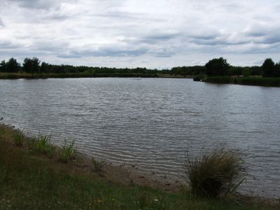
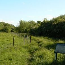
Rushcliffe Country Park is a 210-acre recreational area with over 8 kilometers of trails through meadows, woodlands, and around a man-made lake surrounded by reed beds. The site offers diverse landscapes within walking distance on connected pathways.
The land started as a military depot with numerous buildings and ammunition bunkers from 1940. Its conversion into a public park was completed in 1993, changing the site from wartime use to community recreation.
The Environmental Education Centre here runs programs that help visitors understand wildlife and ecology through hands-on learning in nature. These activities connect your visit with deeper knowledge about the local habitats and what lives in them.
The park has clearly marked trails for walking and cycling with benches, picnic areas, and a recently renovated children's playground available. Plan to wear appropriate footwear as path conditions vary depending on weather and recent maintenance.
Gibbies Wood contains over 100 flower species in its wildflower meadows, creating natural habitats for local wildlife. This botanical richness is often discovered when exploring away from the main pathways.
Location: Ruddington
Inception: 1993
GPS coordinates: 52.89250,-1.14970
Latest update: December 10, 2025 20:08
Ruddington Hall
1.3 km
Nottingham Transport Heritage Centre
869 m
St. Mary's Church, Clifton
3.6 km
Church of the Holy Rood, Edwalton
3.2 km
St. Peter's Church, Ruddington
71 m
St. Peter's Church, Flawford
2 km
Wilwell Farm Nature Reserve
1.9 km
NHR - Nottingham Heritage Railway - (Ruddington, Station)
935 m
Memorial Lychgate At Church Of The Holy Rood
3.2 km
Wesleyan Methodist Chapel
2.2 km
Edwalton Hall Hotel And Adjoining Outbuildings
3 km
Clifton Hall, Nottingham
3.6 km
Manor Farmhouse
52 m
Ruddington War Memorial
31 m
Tower And Spire Of Former Church
2.2 km
Clifton Library
2.3 km
The Old Post Office
3.2 km
Ruddington Library
130 m
White House And Adjoining Barn
3.6 km
K6 Telephone Kiosk
20 m
Headstone 16 Metres South Of South Aisle At Church Of The Holy Rood
3.1 km
EASTHORPE HOUSE, LOUGHBOROUGH ROAD
597 m
St Peter's Rooms
82 m
Southwell House
2.3 km
1, Main Street
2.3 km
27, Farmer Street
2.3 km
Pair Of Headstones 10 Metres And 12 Metres South Of South Aisle At Church Of The Holy Rood
3.1 km
42, Easthorpe Street
277 mVisited this place? Tap the stars to rate it and share your experience / photos with the community! Try now! You can cancel it anytime.
Discover hidden gems everywhere you go!
From secret cafés to breathtaking viewpoints, skip the crowded tourist spots and find places that match your style. Our app makes it easy with voice search, smart filtering, route optimization, and insider tips from travelers worldwide. Download now for the complete mobile experience.
A unique approach to discovering new places❞
— Le Figaro
All the places worth exploring❞
— France Info
A tailor-made excursion in just a few clicks❞
— 20 Minutes