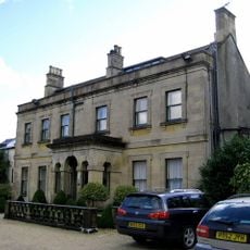
Southill House, Cranmore, Grade I listed building in Cranmore, England
Southill House is a Grade I listed building in Cranmore with a three-storey front elevation defined by classical columns and pilasters. The center section features giant Ionic order pillars with windows set between decorative elements that frame the facade.
This manor house was constructed in the early 18th century but underwent a major transformation when architect John Wood the Younger from Bath redesigned its exterior facade. His work in the late 18th century created the classical front elevation that remains today.
Inside, you will find a late Georgian staircase with ornate plasterwork and wood paneling that shows what wealthy residents valued during that era. These details are still visible today and reflect the craftsmanship of the period.
The exterior can be viewed from the surrounding area as you walk around the property. Keep in mind that this is a private residence, so access is limited to the outside of the building only.
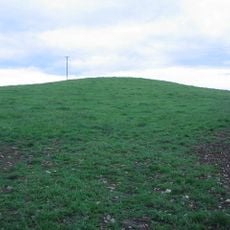
In 1998, a cow grazing on the lawn suddenly fell through the ground, exposing hidden tunnels running beneath the property. This unexpected discovery revealed passages that had remained secret for many years.
Location: Cranmore
GPS coordinates: 51.18190,-2.47080
Latest update: December 13, 2025 12:23
Church of St Bartholomew, Cranmore
803 m
Torr Works
3 km
Doulting Stone Quarry
2.3 km
Cranmore Tower
2.4 km
Tithe Barn, Manor Farm, Doulting
2.5 km
Church of St Mary the Virgin, Batcombe
4 km
East Somerset Railway
585 m
Church of St Aldhelm, Doulting
2.6 km
Church of St Mary
1.8 km
Doulting Railway Cutting
2.4 km
St James' Church
1.6 km
Maes Down
3.2 km
Church of St Mary, Wanstrow
3.9 km
Church of All Saints, Downhead
4.1 km
Milestone At Ngr St 6923 4127
2.5 km
Charlton House
3.9 km
67, Charlton Road
4.1 km
Milestone, 20 Metres West Of Tadhill Farmhouse
4 km
Milestone On Roadside At St 6528 4407
2.4 km
Milestone On Roadside At Ngr St 6548 4540
3.3 km
Milepost On Roadside At Ngr St 6835 3984
3 km
Knatchbull Arms
4.3 km
Milestone, old disused coach road N of Batcombe
3.5 km
Milestone, Burt's Hill, S of village
4.3 km
Milepost, W of Cranmore, nr quarry entrance
1.3 km
Milepost, village of Dean
1.5 km
Milepost, Norwood, E of East Cranmore
2.2 km
Milestone, 400m NE of Wanstrow, near Chancellor's Farm
4.2 kmVisited this place? Tap the stars to rate it and share your experience / photos with the community! Try now! You can cancel it anytime.
Discover hidden gems everywhere you go!
From secret cafés to breathtaking viewpoints, skip the crowded tourist spots and find places that match your style. Our app makes it easy with voice search, smart filtering, route optimization, and insider tips from travelers worldwide. Download now for the complete mobile experience.
A unique approach to discovering new places❞
— Le Figaro
All the places worth exploring❞
— France Info
A tailor-made excursion in just a few clicks❞
— 20 Minutes