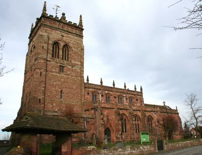
St Mary's Church, Acton, Grade I listed church building in Acton, England
St Mary's Church is a red sandstone building with a lead roof, four-bay nave, and three-bay chancel located in Acton near Nantwich in Cheshire East. The structure combines solid stone walls with Gothic architectural details typical of medieval church design.
The church tower was built around 1180 and ranks among the oldest in Cheshire, though it suffered partial collapse during a storm in 1757. This damage and its repair marked a turning point in the building's later preservation.
The Mainwaring chapel holds a carved wall monument from 1399 featuring an alabaster figure of Sir William Mainwaring, offering insight into medieval burial practices. This display reflects the importance of local gentry in the community's spiritual life.
Plan a visit during regular Anglican services when access is easy and the community is present. It is wise to check opening times beforehand, as the building may be closed between services.
The interior contains stone benches along its walls that give visitors a direct sense of how medieval worshippers used the space. The south aisle also preserves carved Norman-era stones that reveal the ancient roots of the building.
Location: Acton
Inception: 13 century
Architects: Sharpe, Paley and Austin
Architectural style: English Gothic architecture
Website: http://achurchnearyou.com/acton-st-mary
GPS coordinates: 53.07370,-2.55120
Latest update: December 12, 2025 07:57
Dorfold Hall
708 m
Nantwich Aqueduct
1.2 km
Wilbraham's Almshouses, Nantwich
1.4 km
Tollemache Almshouses
1.4 km
Ravensmoor Windmill
855 m
Statue group in forecourt of Dorfold Hall
684 m
The Star Inn
121 m
Shropshire Union Canal Main Line Nantwich Junction Bridge Number 92
786 m
Sparrows Roost
1.4 km
Dorfold Hall Lodge and entrance gates
485 m
Almhouses in St Mary's churchyard north of the church
49 m
153 and 155, Welsh Row
1.4 km
Madam's Farm House
811 m
Sundial in St. Mary's Churchyard north-east of the Church
48 m
Tannery House
1.4 km
Basin End
779 m
108, Welsh Row
1.5 km
St. Mary's Churchyard Wall
57 m
Shropshire Union Canal Main Line Lock Gate North Side Of Nantwich Junction Bridge
779 m
106, Welsh Row
1.5 km
K6 telephone kiosk east of Monks Lane and the parish church
65 m
129, Welsh Row
1.5 km
141, Welsh Row
1.5 km
Church Farm House
61 m
Shropshire Union Canal Main Line Canal Mile Post By Nantwich Junction Bridge
780 m
Glebe House
70 m
Swanley Lock No.2
1.5 km
Milepost, NW of old windmill, W of Cuckoo Lane jct
930 mVisited this place? Tap the stars to rate it and share your experience / photos with the community! Try now! You can cancel it anytime.
Discover hidden gems everywhere you go!
From secret cafés to breathtaking viewpoints, skip the crowded tourist spots and find places that match your style. Our app makes it easy with voice search, smart filtering, route optimization, and insider tips from travelers worldwide. Download now for the complete mobile experience.
A unique approach to discovering new places❞
— Le Figaro
All the places worth exploring❞
— France Info
A tailor-made excursion in just a few clicks❞
— 20 Minutes