Enable Location

We need your location to show you interesting places around you

Discover nearby places

Find interesting locations and hidden gems around you

Precise directions

Get accurate directions and distances to places

Your location is never shared with other users. It's only used when you tap the location button.

St Saviour's Church, Cuerden

Log in to your account

Start exploring — it's free

Trusted by 62,905 travelers worldwide

Continue with Google
Continue with Apple
or

We will send you a code to connect

By continuing, you accept our Terms and Conditions and our Privacy Policy

Check your inbox

We've sent a pincode in your inbox. Please enter the code below.

St Saviour's Church, Cuerden
Discussion Reviews 1 Photos
1.4k Popularity

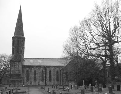
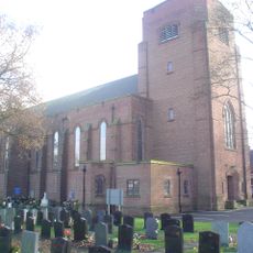
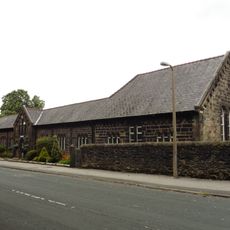
St Saviour's Church, Cuerden, Victorian Anglican church in Cuerden, England

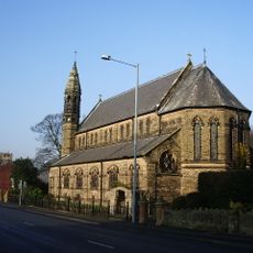
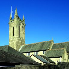
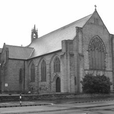
St Saviour's Church is a Victorian sandstone building featuring a tower with an octagonal drum and a spire. The structure contains a five-bay nave with transepts that lead to a semicircular apse.

Edmund Sharpe designed the building in 1836 following Romanesque Revival principles. Half a century later, Thomas Harrison Myres expanded the structure in 1886 by adding the chancel and transepts.

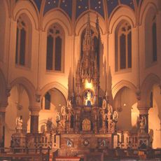
The interior displays cast iron columns supporting a gallery where the royal coat of arms is mounted. The spaces also contain memorials to the Townley Parker family, who held long-standing connections to the area.

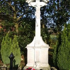
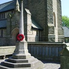
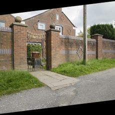
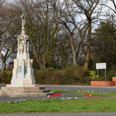
The site is easily accessible on foot and the church is centrally located in Cuerden. The churchyard contains a war memorial with graves from both World Wars that can be easily found during a visit.

The early 20th-century font displays an octagonal bowl supported by angels and features a bronze cover carved with an image of St John the Baptist. This ornate detail is often overlooked but rewards close examination for its fine craftsmanship.

The community of curious travelers

AroundUs brings together thousands of curated places, local tips, and hidden gems, enriched daily by 60,000 contributors worldwide.

Start exploring
Location
Inception
1886
Architects
Edmund Sharpe
Architectural style
Romanesque Revival architecture
GPS coordinates
53.71970,-2.66000
Latest update
December 14, 2025 16:45
Around this place
Cuerden Hall
United Kingdom

Cuerden Hall

1.1 km
St Paul's Church, Farington
United Kingdom

St Paul's Church, Farington

2.7 km
All Saints Church, Higher Walton
United Kingdom

All Saints Church, Higher Walton

2.7 km
Roman Catholic Church of Our Lady and St Patrick
United Kingdom

Roman Catholic Church of Our Lady and St Patrick

2.9 km
Church of St Ambrose
United Kingdom

Church of St Ambrose

2.8 km
Roman Catholic Church of the Blessed Virgin Mary
United Kingdom

Roman Catholic Church of the Blessed Virgin Mary

1.3 km
St Aidan's Church, Bamber Bridge
United Kingdom

St Aidan's Church, Bamber Bridge

1.6 km
Our Lady and St Gerard's Church, Lostock Hall
United Kingdom

Our Lady and St Gerard's Church, Lostock Hall

2.3 km
Walton-le-Dale War Memorial
United Kingdom

Walton-le-Dale War Memorial

2.9 km
Lodge To Farington Lodge
United Kingdom

Lodge To Farington Lodge

2.2 km
Higher Seed Lee Farmhouse
United Kingdom

Higher Seed Lee Farmhouse

1.9 km
St Ambrose WWI Memorial, Leyland
United Kingdom

St Ambrose WWI Memorial, Leyland

2.8 km
Bamber Bridge Library
United Kingdom

Bamber Bridge Library

1.9 km
Clayton Green Library
United Kingdom

Clayton Green Library

1.9 km
Clock House Farmhouse
United Kingdom

Clock House Farmhouse

1.3 km
St Saviour's Church Of England School
United Kingdom

St Saviour's Church Of England School

53 m
Moated site of Clayton Hall, adjacent fishponds and channels
United Kingdom

Moated site of Clayton Hall, adjacent fishponds and channels

3 km
Crow Trees
United Kingdom

Crow Trees

1.6 km
Iron Gates At Foot Of Terrace Steps To East Of Cuerden Hall
United Kingdom

Iron Gates At Foot Of Terrace Steps To East Of Cuerden Hall

1 km
The Old School House
United Kingdom

The Old School House

1.3 km
Milestone Beside Road Outside Number 614
United Kingdom

Milestone Beside Road Outside Number 614

1.7 km
Farington House
United Kingdom

Farington House

2 km
Stable Block Attached To West End Of Cuerden Hall
United Kingdom

Stable Block Attached To West End Of Cuerden Hall

1.1 km
Brownedge War Memorial, Bamber Bridge
United Kingdom

Brownedge War Memorial, Bamber Bridge

1.3 km
Milestone, Walton le Dale, B6230 jct
United Kingdom

Milestone, Walton le Dale, B6230 jct

2.8 km
Milestone, Higher Walton Road, Walton le Dale
United Kingdom

Milestone, Higher Walton Road, Walton le Dale

2.9 km
Milestone, Cuerden Farm
United Kingdom

Milestone, Cuerden Farm

2 km
Milestone, Albert Terrace, Blackburn Road
United Kingdom

Milestone, Albert Terrace, Blackburn Road

2.7 km
Show the full map
« St Saviour's Church, Cuerden - Victorian Anglican church in Cuerden, England » is provided by Around Us (aroundus.com). Images and texts are derived from Wikimedia project under a Creative Commons license. You are allowed to copy, distribute, and modify copies of this page, under the conditions set by the license, as long as this note is clearly visible.

Discover hidden gems everywhere you go!

From secret cafés to breathtaking viewpoints, skip the crowded tourist spots and find places that match your style. Our app makes it easy with voice search, smart filtering, route optimization, and insider tips from travelers worldwide. Download now for the complete mobile experience.

Around Us App Screenshot

A unique approach to discovering new places

Le Figaro

All the places worth exploring

France Info

A tailor-made excursion in just a few clicks

20 Minutes

Around Us
Travel Guide & Maps
Download

Send to your phone

QR Code
1

Open the camera app on your mobile.

2

Point at the QR code with your camera. A notification will appear.

3

Tap the notification to open the link.