Chest opened
+${chestReward.xp} XP
Explorer
NOUVEAU ×${chestReward.collectible.quantity}
tapez pour fermer
Chest locked

Open chests in the app

Around Us is built for your phone — chests unlock when you walk, explore and capture nearby places.

Enable Location

We need your location to show you interesting places around you

Discover nearby places

Find interesting locations and hidden gems around you

Precise directions

Get accurate directions and distances to places

Your location is never shared with other users. It's only used when you tap the location button.

Log in to your account

Start exploring — it's free

Trusted by 72,889 travelers worldwide

Continue with Google
Continue with Apple
or

We will send you a code to connect

By continuing, you accept our Terms and Conditions and our Privacy Policy

Check your inbox

We've sent a pincode in your inbox. Please enter the code below.

Stepper Point
Discussion Reviews Photo
3.6k Popularity

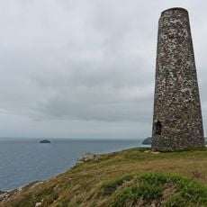
Stepper Point, Coastal headland in Cornwall, England

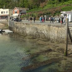
Stepper Point is a coastal headland in Cornwall that rises steeply above the Atlantic Ocean, marking the southwestern entrance to the River Camel. The location features dramatic cliffs and sandy coves scattered along its shoreline.

A navigation tower called the Daymark was built in 1830 on the headland summit to guide ships from afar. During the 19th century, two mining operations also worked on the headland: Wheal Galway for copper extraction and North Treleaver for lead production.

The South West Coast Path runs along this headland and connects Padstow to several beaches, with visitors discovering various geological formations as they walk.

The site is easily reached via the South West Coast Path, which provides pedestrian access along the coast. A volunteer coastwatch station operates on-site and offers a good stopping point with extensive views over the water.

This headland transformed from a mining area into a key maritime observation post, showing how its purpose shifted dramatically over time. Visitors can still sense this historical transition while exploring the site today.

The community of curious travelers

AroundUs brings together thousands of curated places, local tips, and hidden gems, enriched daily by 60,000 contributors worldwide.

Start exploring
GPS coordinates
50.56520,-4.95112
Latest update
December 12, 2025 07:51
Around this place
Prideaux Place
United Kingdom

Prideaux Place

2.5 km
St Enodoc's Church, Trebetherick
United Kingdom

St Enodoc's Church, Trebetherick

2.2 km
Polzeath Beach
United Kingdom

Polzeath Beach

2.7 km
The Shipwrights
United Kingdom

The Shipwrights

2.7 km
Abbey House
United Kingdom

Abbey House

2.7 km
Padstow War Memorial
United Kingdom

Padstow War Memorial

2.3 km
Hillside
United Kingdom

Hillside

2.7 km
Tregirls Cottages
United Kingdom

Tregirls Cottages

1.7 km
40, High Street
United Kingdom

40, High Street

2.6 km
Porthmissen Farmhouse And Garden Walls To Front
United Kingdom

Porthmissen Farmhouse And Garden Walls To Front

2.6 km
11, Cross Street
United Kingdom

11, Cross Street

2.7 km
Garden temple to south west of Prideaux Place
United Kingdom

Garden temple to south west of Prideaux Place

2.6 km
South terrace with grotto niche to south of Prideaux Place
United Kingdom

South terrace with grotto niche to south of Prideaux Place

2.6 km
2, Ruthy's Lane
United Kingdom

2, Ruthy's Lane

2.7 km
Polyphant House  Railings To Front
United Kingdom

Polyphant House Railings To Front

2.7 km
12 And 14, Cross Street
United Kingdom

12 And 14, Cross Street

2.7 km
Wayside cross in the grounds of Prideaux Place 70m SSW of the house
United Kingdom

Wayside cross in the grounds of Prideaux Place 70m SSW of the house

2.6 km
Garden Feature At South End Of South Terrace Of Prideaux Place
United Kingdom

Garden Feature At South End Of South Terrace Of Prideaux Place

2.7 km
North Quay Walls
United Kingdom

North Quay Walls

2.7 km
Footbridge Over Road To North East Of Prideaux Place
United Kingdom

Footbridge Over Road To North East Of Prideaux Place

2.5 km
Walls Enclosing The Gardens To South And East Of Prideaux Place, Flanking The South Entrance And Continuing South From The Mock Fortifications
United Kingdom

Walls Enclosing The Gardens To South And East Of Prideaux Place, Flanking The South Entrance And Continuing South From The Mock Fortifications

2.6 km
Dairy and Grotto
United Kingdom

Dairy and Grotto

2.5 km
Tregea
United Kingdom

Tregea

2.7 km
Footbridge Over Lane To Estate Yard And Flanking Walls Forming North End Of Mock Fortifications To North East Of Prideaux Place
United Kingdom

Footbridge Over Lane To Estate Yard And Flanking Walls Forming North End Of Mock Fortifications To North East Of Prideaux Place

2.5 km
The Daymark
United Kingdom

The Daymark

336 m
Lead bust to south east of Prideaux Place
United Kingdom

Lead bust to south east of Prideaux Place

2.6 km
The Stables
United Kingdom

The Stables

2.5 km
Entrance Gate And Flanking Walls Forming Mock Fortifications To East Of Prideaux Place
United Kingdom

Entrance Gate And Flanking Walls Forming Mock Fortifications To East Of Prideaux Place

2.5 km
Show the full map
Reviews
Share your experience

No review yet

Discussions
Start a discussion...

No discussion yet

« Stepper Point - Coastal headland in Cornwall, England » is provided by Around Us (aroundus.com). Images and texts are derived from Wikimedia project under a Creative Commons license. You are allowed to copy, distribute, and modify copies of this page, under the conditions set by the license, as long as this note is clearly visible.

Discover hidden gems everywhere you go!

From secret cafés to breathtaking viewpoints, skip the crowded tourist spots and find places that match your style. Our app makes it easy with voice search, smart filtering, route optimization, and insider tips from travelers worldwide. Download now for the complete mobile experience.

Around Us App Screenshot

A unique approach to discovering new places

Le Figaro

All the places worth exploring

France Info

A tailor-made excursion in just a few clicks

20 Minutes

Around Us
Travel Guide & Maps
Download

Send to your phone

QR Code
1

Open the camera app on your mobile.

2

Point at the QR code with your camera. A notification will appear.

3

Tap the notification to open the link.