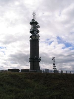
Sutton Common BT Tower, Communication tower in Macclesfield, England.
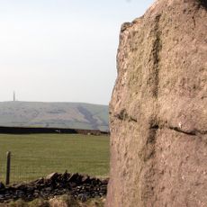
The Sutton Common BT Tower is a 72-meter-tall concrete structure standing on Croker Hill at the western edge of Peak District National Park. The facility houses transmission equipment that connects various radio stations and communication services throughout the region.
The tower was built in the 1960s as a reinforced concrete structure and formed part of the GPO Cold War Backbone network for secure national communications. Its location in the Midlands made it a vital point in the nationwide telecommunications infrastructure during that era.
The tower broadcasts local radio stations that serve surrounding communities with music and news programming. This connection has shaped daily life in the region for many decades.
The tower itself is not open to the public, but the surrounding area offers good walking and photography opportunities from public paths. The best time to visit is during clear weather, when views across the surrounding landscape are at their best.
The tower uses specialized microwave transmission equipment to relay signals between Heaton Park to the north and Pye Green to the south. This relay function connects a large geographic area and was critical to the region's early telecommunications infrastructure.
GPS coordinates: 53.20612,-2.10070
Latest update: December 10, 2025 16:24
Bosley Reservoir
2 km
Church of St Mary the Virgin, Bosley
2.6 km
Macclesfield Canal, Bridge Number 52 At SJ90746800
2.6 km
Queen's Arms Inn
2.6 km
Bridge Number 53
2.8 km
Macclesfield canal bridge number 50 at SJ98206864
2.4 km
Bridge Number 54
2.9 km
Ridge Hall Farmhouse, Ridge Hill
2.9 km
Macclesfield Canal, milestone at SJ 9151 6980
2.9 km
Fern Lee Farmhouse
2.7 km
Outbuildings at Ridge Hall Farm
2.9 km
Boundary Stone At Junction Of Wincle And Sutton Civil Parishes Ngr 9542 6786
2.1 km
School and former Schoolmaster's House
2.5 km
Sundial and shaft south of nave in St Mary the Virgin churchyard
2.6 km
Road Bridge opposite east end of Reservoir Dam
2.3 km
Pott Lords Farmhouse
2.5 km
Macclesfield Canal, Milestone At SJ91166861
2.4 km
Bosley Lock Number 1 and spillway
2.9 km
Canal milestone at SJ 9063 6721
2.8 km
Foxbank
2.1 km
Wayside cross 500m north of Sutton End Farm
2.7 km
Valve House in Reservoir Dam
2.5 km
Milepost, Hammerton Moss
2.9 km
Milepost, S of Hollinset Farm
1.6 km
Milepost, London Road; S of Queen's Arms PH
2.6 km
Milepost, Cluelow Cross
1.6 km
Milepost, N of Greatoak Farm
3 km
Milepost, S of Lowerhouse
2 kmVisited this place? Tap the stars to rate it and share your experience / photos with the community! Try now! You can cancel it anytime.
Discover hidden gems everywhere you go!
From secret cafés to breathtaking viewpoints, skip the crowded tourist spots and find places that match your style. Our app makes it easy with voice search, smart filtering, route optimization, and insider tips from travelers worldwide. Download now for the complete mobile experience.
A unique approach to discovering new places❞
— Le Figaro
All the places worth exploring❞
— France Info
A tailor-made excursion in just a few clicks❞
— 20 Minutes