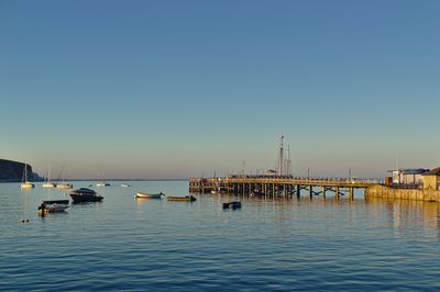
Swanage Pier, Victorian pier in Swanage, England
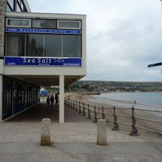
Swanage Pier is a wooden structure extending into Swanage Bay with expansive water views toward Old Harry Rocks and Sandbanks. The pier features shops, cafes, and recreational spaces arranged along its length for visitors to explore.
Built in 1895, it replaced an earlier pier from 1860. The structure played a key role in moving stone from local quarries and serving steamers that brought passengers to the town.
The pier holds a cafe and exhibition space that tell stories about Swanage's connection to the sea. Personal memorial plaques are mounted throughout the structure, making it a place where visitors discover local narratives.
The pier is accessible from the beach and offers a straightforward walk with water and landscape views on both sides. Weather conditions vary by season, and some sections may occasionally close for maintenance.
The Swanage Pier Trust runs a sponsorship program where people can have personal plaques installed on the deck boards. This creates a visible collection of private memories that become part of the pier's physical history.
Location: Swanage
GPS coordinates: 50.60900,-1.95040
Latest update: December 11, 2025 18:06
The Clock Tower
243 m
The Town Hall
607 m
Swanage Museum & Heritage Centre
391 m
Parish Church
882 m
The Anchor Inn
480 m
Ship Hotel
414 m
Purbeck House (Convent Of Our Lady Of Mercy)
693 m
Two Ionic Columns In The Forecourt Of The Grosvenor Hotel
234 m
King Alfred Memorial
479 m
Swanage Museum
391 m
The Mowlem
454 m
Purbeck Hotel
399 m
Royal Victoria Hotel
323 m
Swanage Library
497 m
The Methodist Church And Hall Immediately East And Boundary Walls To West And North
757 m
K6 Telephone Kiosk Outside No 19, High Street (Purbeck Hotel)
390 m
Swanage War Memorial
643 m
The White Swan
461 m
Lloyds Bank
490 m
The Old Water Tower
735 m
Two K6 Telephone Boxes Outside Library
491 m
Eldon Terrace Including Garden Area Walls And No.13 Kings Road East
651 m
15-21 Kings Road East
660 m
Stone Steps To Cliff Place Leading Up From The High Street
389 m
1 and 2, Cliff Place
395 m
Guidestone, Durlston Road at SZ0330278152
726 m
Guidestone - To Durlston Head and Castle, Durlston Country Park
1.5 km
Guidestone, Durlston Road at SZ0320777951
948 mVisited this place? Tap the stars to rate it and share your experience / photos with the community! Try now! You can cancel it anytime.
Discover hidden gems everywhere you go!
From secret cafés to breathtaking viewpoints, skip the crowded tourist spots and find places that match your style. Our app makes it easy with voice search, smart filtering, route optimization, and insider tips from travelers worldwide. Download now for the complete mobile experience.
A unique approach to discovering new places❞
— Le Figaro
All the places worth exploring❞
— France Info
A tailor-made excursion in just a few clicks❞
— 20 Minutes