Toothill Fort

Log in to your account

AroundUs is a community-driven map of interesting places, built by curious explorers like you. It grows with every review, story, and photo you share.
Connect to save your favorite spots, contribute locations, and create personalized routes.
By continuing, you accept our Terms and Conditions and our Privacy Policy
Add to collection
Map
Suggest a change
Share

Toothill Fort, Iron Age hillfort in Hampshire, England.

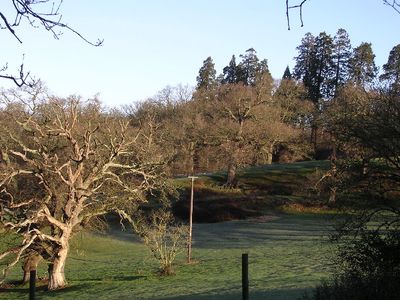
Toothill Fort is an Iron Age defensive structure in Hampshire with a single rampart and ditch system enclosing roughly 4.6 acres of land and featuring an inturned entrance on the eastern side. The site sits on private property but remains visible from surrounding areas, with planted redwood trees marking its position.

This fortified settlement was constructed during the Iron Age and functioned as a defensive center for local communities over several centuries. It remained an important site in southern Britain until the Roman invasion around 43 CE brought major changes to the region.

Pottery and tool fragments found here show how Iron Age people lived and worked in this part of southern Britain. These objects tell us about their daily routines and crafts.

Access to this archaeological site requires permission in advance since it stands on private land where the owner's approval is necessary. The nearest parking is located near North Baddesley, from where the site can be reached on foot.

The fort sits at an elevation of about 84 meters and is marked by a group of redwood trees that make the ancient structure stand out in the flat landscape. These tall trees create an unusual landmark that helps identify the site from a distance.

Location: Hampshire

GPS coordinates: 50.96600,-1.45790

Latest update: December 14, 2025 12:22

Photos
Around this place
Broadlands
United Kingdom

Broadlands

3.2 km
Corn Exchange
United Kingdom

Corn Exchange

3.9 km
Plaza Theatre, Romsey
United Kingdom

Plaza Theatre, Romsey

3.5 km
Church of St Denys
United Kingdom

Church of St Denys

2.5 km
Church of St Boniface
United Kingdom

Church of St Boniface

3.1 km
Church of St John the Baptist
United Kingdom

Church of St John the Baptist

3 km
Church of St John
United Kingdom

Church of St John

1.6 km
The White Horse Hotel
United Kingdom

The White Horse Hotel

3.9 km
Milestone Opposite Churchyard Of Church Of St Denys
United Kingdom

Milestone Opposite Churchyard Of Church Of St Denys

2.5 km
Romsey Signal Box
United Kingdom

Romsey Signal Box

3.7 km
Latimer Arms Public House
United Kingdom

Latimer Arms Public House

3.8 km
Gateway At Ashfield Lodge
United Kingdom

Gateway At Ashfield Lodge

2.3 km
Luzborough House
United Kingdom

Luzborough House

2.1 km
North Baddesley War Memorial
United Kingdom

North Baddesley War Memorial

3 km
North Baddesley Community Library
United Kingdom

North Baddesley Community Library

1.9 km
Tudor Rose Public House
United Kingdom

Tudor Rose Public House

3.8 km
Broadwater House
United Kingdom

Broadwater House

3.8 km
Milestone 10 Metres North East Of Brooklyn
United Kingdom

Milestone 10 Metres North East Of Brooklyn

2 km
Milestone 150 Metres North Of Roundabout On End Of M271
United Kingdom

Milestone 150 Metres North Of Roundabout On End Of M271

1.5 km
Gunville Gatehouse
United Kingdom

Gunville Gatehouse

3.3 km
Milestone, Opposite Junction With Heathlands Road
United Kingdom

Milestone, Opposite Junction With Heathlands Road

3.7 km
Milestone 25 Metres North East Of Junction With Crampmoor Lane
United Kingdom

Milestone 25 Metres North East Of Junction With Crampmoor Lane

3.6 km
Milestone 700 Metres South Of Junction With A27
United Kingdom

Milestone 700 Metres South Of Junction With A27

1.6 km
Manor House
United Kingdom

Manor House

3.6 km
Milestone 20 Metres East Of Junction With Nutburn Lane
United Kingdom

Milestone 20 Metres East Of Junction With Nutburn Lane

3 km
Middle Bridge
United Kingdom

Middle Bridge

3.8 km
Milestone, Winchester Hill, Harefield; opp. service station
United Kingdom

Milestone, Winchester Hill, Harefield; opp. service station

3.4 km
Milestone, Tennis Centre,  Romsey Road, Nursling; opp. the Cedar School for the Physically handicapped,
United Kingdom

Milestone, Tennis Centre, Romsey Road, Nursling; opp. the Cedar School for the Physically handicapped,

2.6 km
Show the full map
Reviews

Visited this place? Tap the stars to rate it and share your experience / photos with the community! Try now! You can cancel it anytime.

« Toothill Fort - Iron Age hillfort in Hampshire, England » is provided by Around Us (aroundus.com). Images and texts are derived from Wikimedia project under a Creative Commons license. You are allowed to copy, distribute, and modify copies of this page, under the conditions set by the license, as long as this note is clearly visible.

Discover hidden gems everywhere you go!

From secret cafés to breathtaking viewpoints, skip the crowded tourist spots and find places that match your style. Our app makes it easy with voice search, smart filtering, route optimization, and insider tips from travelers worldwide. Download now for the complete mobile experience.

Around Us App Screenshot

A unique approach to discovering new places

Le Figaro

All the places worth exploring

France Info

A tailor-made excursion in just a few clicks

20 Minutes