Tutbury Castle, Medieval castle in Tutbury, England
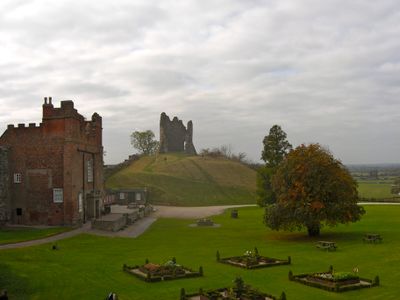
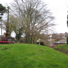
Tutbury Castle is a stone fortress positioned on a ridge above the River Dove, defined by two outer baileys and a D-shaped inner bailey containing a Norman chapel. The site displays characteristic Norman construction with thick defensive walls and strategically placed fortifications.
The castle was granted by William the Conqueror to Henry de Ferrers in 1071, serving as a strategic stronghold in the Midlands region. Norman times shaped its early development and its role in regional power structures.
The garden spaces feature plants and layouts from medieval and Tudor periods, showing how people once grew herbs and vegetables for daily use. These recreated beds help visitors understand the practical gardening methods that sustained castle life across centuries.
The grounds can be explored on foot, though the slopes require sturdy shoes and time for climbing and descending. Visitors should prepare for weather changes and dress appropriately, as the site is largely outdoors.
Mary Queen of Scots endured four separate periods of imprisonment here, each tied to conspiracies against Elizabeth I. Her presence as a high-ranking captive transformed the fortress into a site of national political importance.
Location: Tutbury
Website: https://tutburycastle.com
GPS coordinates: 52.85970,-1.69046
Latest update: December 20, 2025 13:07
Church of St Mary
196 m
St Mary's Church, Marston on Dove
2.4 km
Church of St Paul
1.9 km
Tutbury War Memorial
205 m
North west block of Tutbury Institute fronting street
459 m
Four Gate Piers Adjacent To No 9 Church Road
2.8 km
Wesleyan Methodist Chapel
455 m
Ridgway Memorial Approximately 30M West Of Tower Of Church Of St Mary
3 km
School And Attached House Approximately 100M West Of Church Of St Mary
3 km
Dog And Partridge Hotel
429 m
Fauld Hall
2.5 km
Tutbury Crossing Signal Box
749 m
10, High Street
412 m
8-10, Duke Street
396 m
Lychgate And War Memorial To Church Of St Mary
3 km
Tutbury Bridge
616 m
Milepost At Sk2161028370
1 km
1, Castle Street
316 m
1, Duke Street
418 m
Anglo-Scandinavian cross, St Mary's churchyard
3 km
6 And 6A, High Street
406 m
No 9 And Adjacent Cast Iron Railings
2.8 km
22 And 24, High Street
474 m
Churchyard Railings And Gate Approximately 100M To West Of Church Of St Mary
2.9 km
5, Monk Street
298 m
Tutbury Mill And House
1.3 km
Milepost at SK 224 270
2.6 km
Milepost, S end of Tutbury by-pass, just E of on roundabout
1 kmVisited this place? Tap the stars to rate it and share your experience / photos with the community! Try now! You can cancel it anytime.
Discover hidden gems everywhere you go!
From secret cafés to breathtaking viewpoints, skip the crowded tourist spots and find places that match your style. Our app makes it easy with voice search, smart filtering, route optimization, and insider tips from travelers worldwide. Download now for the complete mobile experience.
A unique approach to discovering new places❞
— Le Figaro
All the places worth exploring❞
— France Info
A tailor-made excursion in just a few clicks❞
— 20 Minutes