Tidbury Ring, Iron Age hillfort in Hampshire, England.
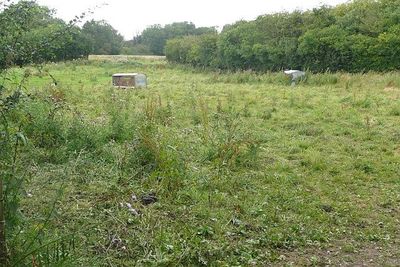
Tidbury Ring is an Iron Age fortification in Hampshire, England, with a defensive earthen bank forming a single protective ring around its perimeter. The structure sits on elevated terrain and remains visible today as a raised embankment surrounding a roughly circular enclosed space.
This hillfort originated during the Iron Age as a defensive stronghold and later saw Roman occupation that left archaeological traces. Excavations in the early 20th century uncovered artifacts from the Roman period, confirming activity at the site centuries after its original construction.
The site reflects how Iron Age communities used elevated locations to establish control and protection over their surroundings. This choice of hilltop location would have made it visible for miles around to both allies and potential threats.
The site is accessible via public pathways and sits adjacent to a main road, making it easy to reach. Sturdy footwear is advisable since the ground is uneven and you will be walking on natural terrain throughout your visit.
The interior of the fort gradually transformed into farmland and remains under agricultural use today, meaning the original defensive purpose has given way to peaceful cultivation. Visitors walking through see a working landscape that masks the ancient martial history beneath their feet.
GPS coordinates: 51.18342,-1.33931
Latest update: December 14, 2025 18:01
Church of All Saints
3.3 km
Church of the Holy Trinity
3.6 km
Church of St James
3.7 km
Church of St Michael
1.8 km
The Cricketers Inn
3.4 km
Table Tomb 5 Metres North Of Church Of All Saints
3.3 km
Sutton Scotney War Memorial
3.5 km
The Swan Inn
3.3 km
Yew Cottage
3.4 km
Table Tomb 9 Metres Noth Of Church Of All Saints
3.3 km
Table Tomb 9 Metres North Of Church Of All Saints
3.3 km
Table Tomb 2 Metres North Of Church Of All Saints
3.3 km
1-3, Hunton Down Lane
3.7 km
Milestone 100 Metres North Of Lower Cranbourne Farm Moated Site
2.6 km
Milestone 1000 Metres North Hunton Grange Farm
2.8 km
Table Tomb 12 Metres North Of Church Of All Saints
3.3 km
Old School House
3.3 km
5 And 6, Hunton Down Lane
3.7 km
Table Tomb 10 Metres South Of Church Of All Saints
3.3 km
Millhouse And Mill
2.9 km
Table Tomb 7 Metres North Of Church Of All Saints
3.3 km
Table Tomb 10 Metres North Of Church Of All Saints
3.3 km
Coach And Horses
3.4 km
Table Tomb 5 Metres North Of Church Of All Saints
3.3 km
The Malt House And Boundary Wall
3.3 km
Hunton House
3.6 km
Milestone, Tidbury Ring
376 m
Milestone, Cranbourne Grange
2.5 kmVisited this place? Tap the stars to rate it and share your experience / photos with the community! Try now! You can cancel it anytime.
Discover hidden gems everywhere you go!
From secret cafés to breathtaking viewpoints, skip the crowded tourist spots and find places that match your style. Our app makes it easy with voice search, smart filtering, route optimization, and insider tips from travelers worldwide. Download now for the complete mobile experience.
A unique approach to discovering new places❞
— Le Figaro
All the places worth exploring❞
— France Info
A tailor-made excursion in just a few clicks❞
— 20 Minutes