Enable Location

We need your location to show you interesting places around you

Discover nearby places

Find interesting locations and hidden gems around you

Precise directions

Get accurate directions and distances to places

Your location is never shared with other users. It's only used when you tap the location button.

Tyneview Park

Log in to your account

Start exploring — it's free

Trusted by 65,200 travelers worldwide

Continue with Google
Continue with Apple
or

We will send you a code to connect

By continuing, you accept our Terms and Conditions and our Privacy Policy

Check your inbox

We've sent a pincode in your inbox. Please enter the code below.

Tyneview Park
Discussion Reviews 1 Photos
4.9k Popularity

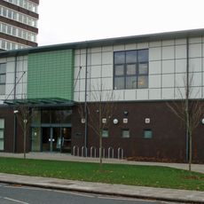
Tyneview Park, Government office complex in Benton, Newcastle upon Tyne, England

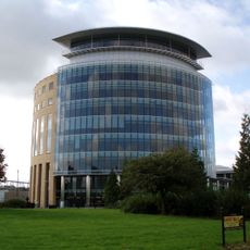
Tyneview Park is an office complex in Benton, a suburb in the northeast of Newcastle upon Tyne, Tyne and Wear. It consists of several three-storey buildings arranged around shared outdoor spaces, with glass-roofed atriums and semi-opaque wall panels that let daylight into the office areas.

The complex was built in 1995 and was one of the first major office investments in this part of Benton. A further building was added about a decade later, bringing the site closer to its current form.

Tyneview Park is best known as the headquarters of the DVLA's Northern Ireland operations and, more prominently, the Driver and Vehicle Licensing Agency regional office. The site is a major local employer and gives the Benton area much of its working-day energy.

The complex is not open to the general public and functions purely as a working site, so access is limited to those with a reason to be there. If you are visiting someone at the offices, it is worth confirming the exact building in advance, as the site covers several separate blocks.

The site has its own dedicated restaurant building and a small fitness facility for staff, which is unusual for a suburban office park of this type. Both amenities sit within the atrium spaces, making the complex largely self-contained for the people who work there day to day.

The community of curious travelers

AroundUs brings together thousands of curated places, local tips, and hidden gems, enriched daily by 60,000 contributors worldwide.

Start exploring
Location
GPS coordinates
55.01400,-1.58700
Latest update
March 3, 2026 08:16
Around this place
Jesmond Dene House
United Kingdom

Jesmond Dene House

2 km
United Kingdom

Henderson Hall

2 km
Gosforth Park Nature Reserve
United Kingdom

Gosforth Park Nature Reserve

2.1 km
Partnership House
United Kingdom

Partnership House

2.5 km
Banqueting House With Added Gatehouse And Other Extensions
United Kingdom

Banqueting House With Added Gatehouse And Other Extensions

2.4 km
St Bartholomew's Church, Long Benton
United Kingdom

St Bartholomew's Church, Long Benton

1.2 km
Holy Name parish, Jesmond
United Kingdom

Holy Name parish, Jesmond

2.3 km
Gosforth Central Park
United Kingdom

Gosforth Central Park

2.2 km
1914-18 War Memorial In St Bartholomew's Churchyard, Longbenton
United Kingdom

1914-18 War Memorial In St Bartholomew's Churchyard, Longbenton

1.1 km
Church of St Nicholas
United Kingdom

Church of St Nicholas

1.7 km
Church of St George
United Kingdom

Church of St George

2.3 km
Roman Catholic Church of St Charles, Attached Presbytery and Boundary Wall to South and South West
United Kingdom

Roman Catholic Church of St Charles, Attached Presbytery and Boundary Wall to South and South West

2.1 km
St Mary's Chapel, Jesmond
United Kingdom

St Mary's Chapel, Jesmond

2.5 km
North Gosforth Chapel
United Kingdom

North Gosforth Chapel

2.2 km
The County Hotel
United Kingdom

The County Hotel

2.4 km
Gosforth War Memorial Pillar
United Kingdom

Gosforth War Memorial Pillar

2.2 km
Town Moor Boundary Stone Opposite Number 73
United Kingdom

Town Moor Boundary Stone Opposite Number 73

2.4 km
Globe Cinema
United Kingdom

Globe Cinema

2.3 km
Dial Cottage
United Kingdom

Dial Cottage

1.8 km
Gosforth Library
United Kingdom

Gosforth Library

2.3 km
Footbridge North East Of Banqueting Hall
United Kingdom

Footbridge North East Of Banqueting Hall

2.3 km
Salters' Bridge
United Kingdom

Salters' Bridge

1.1 km
Main Dike Stone
United Kingdom

Main Dike Stone

1.6 km
High Heaton Library
United Kingdom

High Heaton Library

2 km
Jesmond Dene Mill
United Kingdom

Jesmond Dene Mill

1.8 km
Boundary Mark In Wall At Junction With South Side Of Moorfield
United Kingdom

Boundary Mark In Wall At Junction With South Side Of Moorfield

2.2 km
Milepost At Junction Of Front Street And Manorfields
United Kingdom

Milepost At Junction Of Front Street And Manorfields

1.2 km
Milepost, Great North Road, by Gosforth Central Middle School field
United Kingdom

Milepost, Great North Road, by Gosforth Central Middle School field

2.2 km
Show the full map
Reviews
Share your experience

No review yet

Discussions
Start a discussion...

No discussion yet

« Tyneview Park - Government office complex in Benton, Newcastle upon Tyne, England » is provided by Around Us (aroundus.com). Images and texts are derived from Wikimedia project under a Creative Commons license. You are allowed to copy, distribute, and modify copies of this page, under the conditions set by the license, as long as this note is clearly visible.

Discover hidden gems everywhere you go!

From secret cafés to breathtaking viewpoints, skip the crowded tourist spots and find places that match your style. Our app makes it easy with voice search, smart filtering, route optimization, and insider tips from travelers worldwide. Download now for the complete mobile experience.

Around Us App Screenshot

A unique approach to discovering new places

Le Figaro

All the places worth exploring

France Info

A tailor-made excursion in just a few clicks

20 Minutes

Around Us
Travel Guide & Maps
Download

Send to your phone

QR Code
1

Open the camera app on your mobile.

2

Point at the QR code with your camera. A notification will appear.

3

Tap the notification to open the link.