Watergate Beach

Log in to your account

AroundUs is a community-driven map of interesting places, built by curious explorers like you. It grows with every review, story, and photo you share.
Connect to save your favorite spots, contribute locations, and create personalized routes.
Continue with Google
Continue with Apple
Continue with X
Continue with Facebook
Continue with email
By continuing, you accept our Terms and Conditions and our Privacy Policy
Create an account

Watergate Beach

Add to collection
Map
Suggest a change
Share

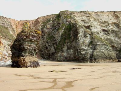
Watergate Beach, Sandy beach in Watergate Bay, Cornwall, United Kingdom

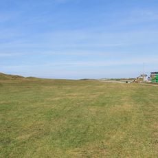
Watergate Beach is a sandy shore in Watergate Bay, Cornwall, stretching for about 2 miles along the Atlantic coast. The water is clear and suitable for swimming, while golden sand covers large areas for relaxation.

The beach gained prominence in 2007 when it hosted the English National Surfing Championships, establishing its status in British water sports. This event marked a turning point that recognized the location's natural advantages for competitive wave sports.

The beach holds strong ties to local surf communities, with water sports enthusiasts regularly practicing their skills throughout the seasons. Its reliable waves and sandy shores make it a natural gathering place for people who pursue these activities.

The beach is reachable from Newquay and offers restrooms, shops, cafes, and parking available on-site. Conditions vary by season, so check local weather before visiting to plan your time there.

Horse Rock is a natural rock formation on the beach that shapes wave patterns in distinctive ways. This feature draws surfers of varying experience levels because it creates different types of waves suitable for different skills.

GPS coordinates: 50.44400,-5.04000

Latest update: December 14, 2025 18:40

Photos
Around this place
Newquay Zoo
United Kingdom

Newquay Zoo

4.2 km
Huer's Hut
United Kingdom

Huer's Hut

4.4 km
Carnanton House
United Kingdom

Carnanton House

3.6 km
Porth Reservoir
United Kingdom

Porth Reservoir

3.8 km
St Columb Minor Church
United Kingdom

St Columb Minor Church

2.5 km
Promontory fort and two bowl barrows at Trevelgue Head
United Kingdom

Promontory fort and two bowl barrows at Trevelgue Head

2.4 km
Church of St Mawgan
United Kingdom

Church of St Mawgan

3.2 km
Wesleyan Methodist Chapel With Attached Coach Houses
United Kingdom

Wesleyan Methodist Chapel With Attached Coach Houses

2.7 km
Lanherne Carmelite Convent
United Kingdom

Lanherne Carmelite Convent

3.1 km
King Monument In The Churchyard About 10 Metres South Of South Aisle Of Church Of St Columba
United Kingdom

King Monument In The Churchyard About 10 Metres South Of South Aisle Of Church Of St Columba

2.5 km
Trenance Viaduct
United Kingdom

Trenance Viaduct

4.4 km
Lychgate At The South West Entrance To The Churchyard Of Church Of St Columba
United Kingdom

Lychgate At The South West Entrance To The Churchyard Of Church Of St Columba

2.5 km
Milestone At Sw 882634
United Kingdom

Milestone At Sw 882634

4.2 km
The Old Vicarage
United Kingdom

The Old Vicarage

2.9 km
Milestone
United Kingdom

Milestone

2.7 km
Milestone At Sw 840 617
United Kingdom

Milestone At Sw 840 617

3.2 km
Kimberley House
United Kingdom

Kimberley House

2.5 km
Colan Barton Farmhouse
United Kingdom

Colan Barton Farmhouse

4.4 km
Milestone At Sw 852 623
United Kingdom

Milestone At Sw 852 623

2.7 km
Three bowl barrows, once part of a round barrow cemetery, at Barrowfields
United Kingdom

Three bowl barrows, once part of a round barrow cemetery, at Barrowfields

3.5 km
Tolcarne Cross
United Kingdom

Tolcarne Cross

4 km
Cross In The Churchyard About 18 Metres East Of South Aisle Of Church Of St Mawgan
United Kingdom

Cross In The Churchyard About 18 Metres East Of South Aisle Of Church Of St Mawgan

3.2 km
Doublestiles Cross, at the junction of Duchy Avenue and Henver Road
United Kingdom

Doublestiles Cross, at the junction of Duchy Avenue and Henver Road

3 km
Milestone At Sw 867 629
United Kingdom

Milestone At Sw 867 629

3.1 km
Milestone Outside No.34 Henver Road
United Kingdom

Milestone Outside No.34 Henver Road

3.3 km
Cross In The Churchyard About 2 Metres East Of Chancel Of Church Of St Mawgan
United Kingdom

Cross In The Churchyard About 2 Metres East Of Chancel Of Church Of St Mawgan

3.2 km
Signpost At The North Side Of The Churchyard Of Church Of St Mawgan
United Kingdom

Signpost At The North Side Of The Churchyard Of Church Of St Mawgan

3.2 km
Milestone, lay-by, by footpath sign
United Kingdom

Milestone, lay-by, by footpath sign

817 m
Show the full map
Reviews

Visited this place? Tap the stars to rate it and share your experience / photos with the community! Try now! You can cancel it anytime.

« Watergate Beach - Sandy beach in Watergate Bay, Cornwall, United Kingdom » is provided by Around Us (aroundus.com). Images and texts are derived from Wikimedia project under a Creative Commons license. You are allowed to copy, distribute, and modify copies of this page, under the conditions set by the license, as long as this note is clearly visible.

Discover hidden gems everywhere you go!

From secret cafés to breathtaking viewpoints, skip the crowded tourist spots and find places that match your style. Our app makes it easy with voice search, smart filtering, route optimization, and insider tips from travelers worldwide. Download now for the complete mobile experience.

Around Us App Screenshot

A unique approach to discovering new places

Le Figaro

All the places worth exploring

France Info

A tailor-made excursion in just a few clicks

20 Minutes