Welford Park, English country house in Welford, England
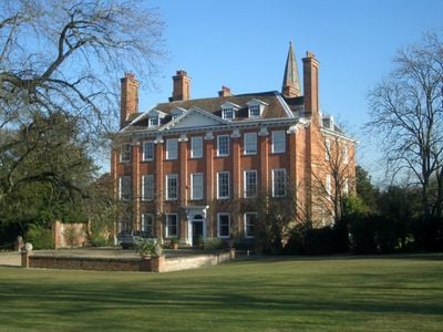
Welford Park is a country house in Welford, England, displaying red brick classical architecture with a central three-story block and two symmetrical side wings. The estate extends across wooded grounds along the River Lambourn, with mature trees planted in the 18th century connecting formal gardens to informal woodland paths.
The site began as a farm property of Abingdon Abbey in medieval times and became a royal hunting lodge after 1540 when Henry VIII acquired it. The current structure dates largely from the early 1600s when the Eyre family rebuilt the house and has remained in their hands ever since.
The name Welford comes from Old English 'welig' meaning willow, reflecting the water meadows that still border the property today. During February, thousands of visitors walk quietly through the woodland carpets of white flowers that have naturalized here over centuries.
The estate opens in late winter for snowdrop visits, with paths through the woods mostly level and grassy. Tours focus on the outdoor areas while the house itself remains privately occupied and closed to the public.
The large white tent structure that stood on the lawn during the baking show filming is long gone, but visitors sometimes recognize the view from the house toward the woods. The snowdrops visitors see today grow from bulbs introduced over 100 years ago that now self-seed throughout the grounds.
Location: Welford
GPS coordinates: 51.45600,-1.41358
Latest update: December 5, 2025 22:22
Elcot Park Hotel
4.1 km
Snelsmore Common
5.6 km
St Thomas' Church, East Shefford
2.3 km
Boxford Water Meadows
2.3 km
Leckhampstead War Memorial
4.5 km
Church of St Gregory
42 m
Church of St Swithin
2.1 km
Church of St James
4.4 km
Parish Church of St Andrew
2.5 km
Church of St James
4.2 km
Church of St John
5.5 km
Church of St Andrew
4.8 km
Church of St Stephen
4.2 km
Church of St Mary
3.6 km
The Swan Inn
3.2 km
Spring Cottages Springfields
5.4 km
Tomb Approximately 2 Yards East Of Chancel Of St Andrews Church
2.6 km
Eassell Tomb Approximately 2 Yards To East Of Chancel Of St Andrews Church
2.6 km
Bowl barrow on Barrow Hill, Hungerford Newtown
5.5 km
Milestone At Ngr Su 4103 6839
4.8 km
Milestone Opposite Meadowside
3.2 km
Milestone On Road To Wantage North Of Access To Henley Farm
5.5 km
Milestone On A4 (T) At Junction Of A4 And Milkhouse Road
5.2 km
Milestone Approximately 150 Metres North Of Buckham Hill
4.2 km
Milestone At Su 378 684
5.7 km
Gate Piers and Gates at Benham Park, West Lodge
5.5 km
Milestone On East Side Of Road To Wantage, 100 Metres North Of Road To South Hidden Farmhouse
3.2 km
Milestone At Su 394 685
4.9 kmReviews
Visited this place? Tap the stars to rate it and share your experience / photos with the community! Try now! You can cancel it anytime.
Discover hidden gems everywhere you go!
From secret cafés to breathtaking viewpoints, skip the crowded tourist spots and find places that match your style. Our app makes it easy with voice search, smart filtering, route optimization, and insider tips from travelers worldwide. Download now for the complete mobile experience.
A unique approach to discovering new places❞
— Le Figaro
All the places worth exploring❞
— France Info
A tailor-made excursion in just a few clicks❞
— 20 Minutes