Welland Viaduct, Railway viaduct in Harringworth, England
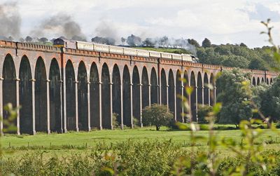
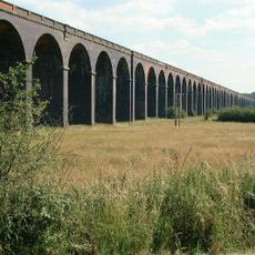
The Welland Viaduct is a railway crossing in Harringworth, England, built from red brick and extending for 1165 meters (1275 yards). The construction spans the Welland valley with 82 arches, each measuring roughly 12 meters (40 feet) in width.
The Midland Railway built the crossing between 1876 and 1878, using around 30 million bricks in total. Workers produced the building material on site in temporary kilns to keep transport costs low.
Locals often refer to the structure simply as Harringworth Viaduct, after the village at its northern end. Walkers on the Jurassic Way footpath passing through the valley frequently pause to photograph the long rows of red brick arches.
The railway line runs over the crossing and carries daily passenger trains between Melton Mowbray and London St Pancras via Corby. Footpaths in the valley below offer several vantage points from which you can see the full length of the arch sequence.
A German airship attempted to bomb the crossing during World War I because troop trains traveled along the line toward ports on the English Channel. The attack missed its target and only caused minor damage in the surrounding area.
Location: Seaton
Location: Harringworth
Inception: 1874
Official opening: 1878
GPS coordinates: 52.57151,-0.65332
Latest update: December 5, 2025 22:29
Lyddington Bede House
3.9 km
Church of St Andrew
3.1 km
Church of St Andrew
3.9 km
Church of All Hallows
997 m
Seaton Meadows
167 m
Church of St Mary
3.1 km
Church of St John the Baptist
3.1 km
Church of St James the Great
3.8 km
Church of St John the Baptist
567 m
Gretton War Memorial, Northamptonshire
3.8 km
Turtle Bridge
1.5 km
The White Swan Public House And Attached Carriage Arch
656 m
Morcott Hall School
3 km
Firdale House
3 km
Market Cross
701 m
Stoneleigh
3.9 km
9 And 9A, High Street
3 km
Wall And Gate To Firdale House
3 km
3 And 5, High Street
3 km
The Yews
3.8 km
The Manor House
3 km
Harringworth Lodge
3.2 km
Stone Shaft Approximately 30 Metres East Of Harringworth Lodge
3.3 km
Windmill
2.8 km
315th Troop Carrier Group USAAF Memorial, Spanhoe
2.8 km
17, High Street
3 km
19-23, High Street
3 km
Milepost, Stamford Road; Peterborough Road jct
2.7 kmVisited this place? Tap the stars to rate it and share your experience / photos with the community! Try now! You can cancel it anytime.
Discover hidden gems everywhere you go!
From secret cafés to breathtaking viewpoints, skip the crowded tourist spots and find places that match your style. Our app makes it easy with voice search, smart filtering, route optimization, and insider tips from travelers worldwide. Download now for the complete mobile experience.
A unique approach to discovering new places❞
— Le Figaro
All the places worth exploring❞
— France Info
A tailor-made excursion in just a few clicks❞
— 20 Minutes