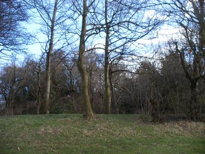
Wakefield Castle, Medieval castle remains in Thornes Park, Wakefield, England
Wakefield Castle is a medieval fortification consisting of an earthen mound approximately 9 meters high, surrounded by a square-shaped inner bailey. The structure sits within Thornes Park in central Wakefield and offers views across the River Calder toward the surrounding landscape.
The fortification was built in the mid-12th century during the English civil war between Stephen and Matilda, commissioned by a local nobleman. Archaeological evidence suggests it may have been constructed without formal authorization and was abandoned before completion.
The fortress served as a seat of local power and control in the region, with its earthen mound representing significant medieval engineering work. Visitors walking through Thornes Park today can observe the remnants and understand how such structures shaped the medieval landscape.
The site is accessible through Thornes Park, a green space near Wakefield town center with easy walking paths. The remains are freely open year-round and offer a pleasant spot to explore medieval history without requiring tickets or advance planning.
Excavations from 1953 revealed that the castle may have been an abandoned building project caught in a period of political turmoil. This makes it a rare example of a medieval fortification that never fully functioned as a residence or administrative center.
Location: Wakefield
GPS coordinates: 53.67260,-1.50719
Latest update: December 8, 2025 21:03
HM Prison Wakefield
1.1 km
Theatre Royal, Wakefield
1.1 km
Thornes Park
186 m
67 and 69, Westgate
1.1 km
Church of St James
341 m
65, Westgate
1.1 km
Westgate Wesleyan Methodist Church
814 m
Drury Lane Library
1.1 km
Westgate Unitarian Chapel
1.1 km
162, Westgate
915 m
Playhouse
1.1 km
61–63 Westgate
1.1 km
The Elephant And Castle Public House
1 km
Bridge over Ings Beck
783 m
Unity Works
934 m
Glad Tidings Hall
987 m
62, George Street
962 m
166, Westgate
910 m
Zion United Reformed Church and lodge to north east
1.1 km
Urban Studies Centre
1.1 km
Pemberton House
1 km
Navigation Warehouse
1 km
Ninety-Nine Arches Viaduct
676 m
Clark's Brewery
985 m
Milne's Orangery (unitarian Chapel Hall)
1.1 km
147 And 149, Westgate
887 m
Milestone, Denby Dale Road, bridge over Ings Beck
783 m
Stone Warehouse To North Of Calder And Hebble Navigation Warehouse
1.1 kmVisited this place? Tap the stars to rate it and share your experience / photos with the community! Try now! You can cancel it anytime.
Discover hidden gems everywhere you go!
From secret cafés to breathtaking viewpoints, skip the crowded tourist spots and find places that match your style. Our app makes it easy with voice search, smart filtering, route optimization, and insider tips from travelers worldwide. Download now for the complete mobile experience.
A unique approach to discovering new places❞
— Le Figaro
All the places worth exploring❞
— France Info
A tailor-made excursion in just a few clicks❞
— 20 Minutes