Windgather Rocks, Climbing area in Hartington Upper Quarter, United Kingdom
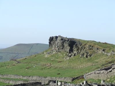
Windgather Rocks is a climbing area on the Derbyshire-Cheshire border featuring gritstone cliffs that rise steeply from the moorland below. The crag offers numerous climbing routes across its exposed rock faces, with heights ranging from 7 to 15 meters.
The site functioned as a sandstone quarry during the Victorian period from about 1880 to 1900, providing slate stone for roofing materials in the nearby village of Kettleshulme. This quarrying era shaped the exposed rock formations visible today.
The crag contains 54 traditional climbing routes that have shaped local climbing practices and contributed to the development of climbing techniques in Peak District.
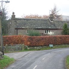
Access to the climbing area requires a short walk of about two minutes from parking areas located in lay-bys directly below the crag after driving steeply uphill. These parking spots are straightforward to find and provide direct access to the site.
The rocks display north-south faulting patterns and contain thin coal seams in their upper layers, revealing the area's past as a coal-bearing region. These geological features give the formation a distinctive character beyond its value as a climbing destination.
Location: Hartington Upper Quarter
Location: Kettleshulme
GPS coordinates: 53.30165,-2.01046
Latest update: December 12, 2025 09:01
Fernilee Reservoir
2.4 km
Jenkin Chapel
2 km
St James' Church
2 km
Saltersford Hall And Attached Farm Buildings
2.3 km
Reed Bridge
1.5 km
Charles Head House
1.5 km
Gap House
2 km
The Murder Stone: a standing stone 150m north west of Cornfield Farm
3 km
Well House Farmhouse
1.8 km
Clayton Fold House
1.5 km
Paddock Lodge
1.5 km
Road bridge 20 metres south south west of Reed Bridge
1.5 km
Kishfield Bridge
2.4 km
Summerclose Farmhouse and attached barn
1.4 km
Anglo Scandinavian high cross known as the Shall Cross
2.6 km
Thorneycroft Farmhouse
1.1 km
Wayside shrine at SK 0070 7525
2.5 km
Taxal Rectory
1.9 km
Milestone at SJ 9737 7850
2 km
Dales Cottage Dales Farmhouse
1.5 km
Grove Cottage Grove House
2.1 km
Carthouse at Cornfields Farm
2.8 km
Milestone 80 metres east of Gnathole
1.7 km
Milestone 280 Metres East Of Glebe House
1.8 km
Shippon and hayloft at Cornfields Farmhouse
2.8 km
Grove Mill
2.2 km
Bowl barrow at Ox Close
2.4 km
Toddbrook Reservoir
2.8 kmVisited this place? Tap the stars to rate it and share your experience / photos with the community! Try now! You can cancel it anytime.
Discover hidden gems everywhere you go!
From secret cafés to breathtaking viewpoints, skip the crowded tourist spots and find places that match your style. Our app makes it easy with voice search, smart filtering, route optimization, and insider tips from travelers worldwide. Download now for the complete mobile experience.
A unique approach to discovering new places❞
— Le Figaro
All the places worth exploring❞
— France Info
A tailor-made excursion in just a few clicks❞
— 20 Minutes