Enable Location

We need your location to show you interesting places around you

Discover nearby places

Find interesting locations and hidden gems around you

Precise directions

Get accurate directions and distances to places

Your location is never shared with other users. It's only used when you tap the location button.

Mount Caburn

Log in to your account

Start exploring — it's free

Trusted by 65,482 travelers worldwide

Continue with Google
Continue with Apple
or

We will send you a code to connect

By continuing, you accept our Terms and Conditions and our Privacy Policy

Check your inbox

We've sent a pincode in your inbox. Please enter the code below.

Discussion Reviews 1 Photos
5.8k Popularity

Mount Caburn, Iron Age hillfort in Glynde, England

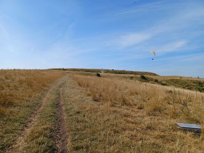
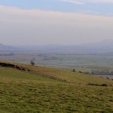
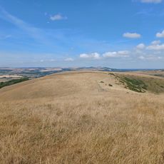
Mount Caburn is an Iron Age hillfort on a chalk hill near Glynde, in the South Downs of England, with defensive ramparts and ditches cut into its northern slopes. The site is also a scheduled monument and contains bowl barrows, making it one of the more layered prehistoric sites in this part of the country.

The fort was built in the middle Iron Age as a defended settlement, and excavations starting in 1877 uncovered burial pits containing weapons, tools, pottery and coins. These finds showed the site was used across several centuries, with later activity suggesting continued importance into the Romano-British period.

Local folklore says the Devil threw earth here while digging elsewhere in the region, which is why the hill rises so sharply from the surrounding flat land. This story has been told for centuries and shows how people tried to make sense of such an unusual landform in an otherwise gentle landscape.

The hill is reached on foot from Glynde village, and the local train station makes it easy to arrive without a car. The path up is steep and crosses open grassland, so sturdy footwear is worth bringing, especially after rain.

The chalk slopes of the hill support one of the largest populations of burnt-tip and pyramidal orchids in Britain. These rare plants in turn attract species such as the Adonis blue and chalkhill blue butterflies, which are rarely seen in such numbers elsewhere.

The community of curious travelers

AroundUs brings together thousands of curated places, local tips, and hidden gems, enriched daily by 60,000 contributors worldwide.

Start exploring
Location
GPS coordinates
50.86162,0.05096
Latest update
March 3, 2026 22:41
Reviews
Share your experience

No review yet

Discussions
Start a discussion...

No discussion yet

« Mount Caburn - Iron Age hillfort in Glynde, England » is provided by Around Us (aroundus.com). Images and texts are derived from Wikimedia project under a Creative Commons license. You are allowed to copy, distribute, and modify copies of this page, under the conditions set by the license, as long as this note is clearly visible.

Discover hidden gems everywhere you go!

From secret cafés to breathtaking viewpoints, skip the crowded tourist spots and find places that match your style. Our app makes it easy with voice search, smart filtering, route optimization, and insider tips from travelers worldwide. Download now for the complete mobile experience.

Around Us App Screenshot

A unique approach to discovering new places

Le Figaro

All the places worth exploring

France Info

A tailor-made excursion in just a few clicks

20 Minutes

Around Us
Travel Guide & Maps
Download

Send to your phone

QR Code
1

Open the camera app on your mobile.

2

Point at the QR code with your camera. A notification will appear.

3

Tap the notification to open the link.