Severn Railway Bridge, Railway bridge in Lydney, England
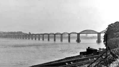
The Severn Railway Bridge was a rail crossing over the River Severn between Lydney and Sharpness, made up of twenty-two spans and reaching a total length of 4,162 feet (1,268 meters). Its design relied on narrow iron piers that carried the weight of the track and allowed trains to cross the wide river.
The bridge opened in 1879 to carry coal from the Forest of Dean to the docks at Sharpness and to shorten the journey between Bristol and Cardiff. A collision with a tanker in 1960 damaged the structure so badly that it closed and was later taken down.
The opening ceremony gathered 400 people who traveled in special carriages, marking a significant advancement in regional transportation infrastructure.
The bridge no longer stands, but its former route can be traced from the riverbank at Lydney and Sharpness, where remnants of the piers remain visible in the riverbed at low tide. Information panels on site help visitors understand the location and function of the original structure.
After the structure was taken down, sections of the ironwork were shipped to Chile and reused to build a road viaduct. This second life shows how building materials from the 19th century continued to serve in a completely different region and purpose.
GPS coordinates: 51.73267,-2.47400
Latest update: December 5, 2025 22:29
Berkeley Arms, Purton
1.9 km
Clarke's Pool Meadow SSSI
2.3 km
Church of St Mary
4.3 km
Church of All Saints
3.3 km
Church of All Saints
3.2 km
Berkeley Pill Front light
3.8 km
Cock Inn
2.8 km
The Yew Tree (Public House)
3.2 km
Purton Viaduct
1.1 km
Naas House
3.3 km
Berkeley Pill Rear light
4 km
Bridgekeeper's House On The Gloucester Sharpness Canal
1.9 km
Lydney Harbour
3.5 km
Milepost At National Grid Reference So 682 038
830 m
Milestone, near telephone box
3.2 km
Milepost At National Grid Reference So 708 040
3.4 km
Pedestrian Bridge Over Disused Rail Line, About 75 Metres East Of Church Of St Mary
4.2 km
Hagloe House
2.8 km
Drakes House
1.7 km
Wanswell Court Farmhouse
3.3 km
Milepost At National Grid Reference So 694 041
2 km
Milestone, 300m N of jct to Purton
2.1 km
Milestone, between Viney Hill and Etloe
2.1 km
Milestone, Purton Wood
990 m
Milestone, opp. Swan Lane 300m N of Blakeney
2.3 km
Milestone, Abwell, in old road loop, opp. sports ground
3.2 km
Milestone, Allaston Meend
3.5 km
Milestone, Riddle Street
2.2 kmVisited this place? Tap the stars to rate it and share your experience / photos with the community! Try now! You can cancel it anytime.
Discover hidden gems everywhere you go!
From secret cafés to breathtaking viewpoints, skip the crowded tourist spots and find places that match your style. Our app makes it easy with voice search, smart filtering, route optimization, and insider tips from travelers worldwide. Download now for the complete mobile experience.
A unique approach to discovering new places❞
— Le Figaro
All the places worth exploring❞
— France Info
A tailor-made excursion in just a few clicks❞
— 20 Minutes