Enable Location

We need your location to show you interesting places around you

Discover nearby places

Find interesting locations and hidden gems around you

Precise directions

Get accurate directions and distances to places

Your location is never shared with other users. It's only used when you tap the location button.

Dollis Brook Viaduct

Log in to your account

Start exploring — it's free

Trusted by 62,569 travelers worldwide

Continue with Google
Continue with Apple
or

We will send you a code to connect

By continuing, you accept our Terms and Conditions and our Privacy Policy

Check your inbox

We've sent a pincode in your inbox. Please enter the code below.

Dollis Brook Viaduct

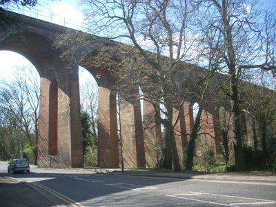
Dollis Brook Viaduct, Railway viaduct in Finchley, United Kingdom.

The Dollis Brook Viaduct is a railway crossing in Finchley that consists of thirteen arches built from brick. This structure connects two Underground stations and spans across a valley with multiple levels of elevation.

The structure was designed in the 1860s for a new railway line that was meant to connect North London with the city center. The project was part of a wave of railway expansion during the Victorian era.

The viaduct is a familiar landmark shaped by Victorian engineering traditions, with its distinctive brick arches defining the local character. Residents recognize it as a historic fixture that has anchored the neighborhood's identity for generations.

The structure is easy to see from nearby roads and the closest station is only a short walk away. Visitors should note that active railway tracks are dangerous and viewing should only be done from designated public areas.

Despite its modest appearance, it stands at one of the highest points of the entire Underground network and offers views across the surrounding valley from certain angles. This height allows the valley and landscape below to be seen in a way that many visitors overlook.

The community of curious travelers

AroundUs brings together thousands of curated places, local tips, and hidden gems, enriched daily by 60,000 contributors worldwide.

Start exploring
Official opening
August 22, 1867
Part of
Northern line
GPS coordinates
51.60510,-0.20220
Latest update
December 11, 2025 11:03
Around this place
Avenue House
United Kingdom

Avenue House

1 km
St Mary-at-Finchley Church
United Kingdom

St Mary-at-Finchley Church

676 m
Avenue House Grounds
United Kingdom

Avenue House Grounds

1 km
St Margaret's Church, Finchley
United Kingdom

St Margaret's Church, Finchley

650 m
Milestone 20 Yards South Of Entrance To Hendon Cemetery (Almost Buried)
United Kingdom

Milestone 20 Yards South Of Entrance To Hendon Cemetery (Almost Buried)

690 m
St Philip's Church, Finchley
United Kingdom

St Philip's Church, Finchley

883 m
Finchley Garden Village War Memorial
United Kingdom

Finchley Garden Village War Memorial

818 m
Finchley Church End Library
United Kingdom

Finchley Church End Library

755 m
Monument To Major Cartwright In St Mary At Finchley Churchyard
United Kingdom

Monument To Major Cartwright In St Mary At Finchley Churchyard

674 m
King Edward Hall
United Kingdom

King Edward Hall

729 m
Tombstone To Roberts In St Mary At Finchley Churchyard
United Kingdom

Tombstone To Roberts In St Mary At Finchley Churchyard

683 m
Tomb of Charles Atkin Swan
United Kingdom

Tomb of Charles Atkin Swan

721 m
Cattle Trough
United Kingdom

Cattle Trough

721 m
Chest Tomb With Railings, To South Of Cartwright Monument In St Mary At Finchley Churchyard
United Kingdom

Chest Tomb With Railings, To South Of Cartwright Monument In St Mary At Finchley Churchyard

649 m
Chest Tomb To Edward Burford In St Mary At Finchley Churchyard
United Kingdom

Chest Tomb To Edward Burford In St Mary At Finchley Churchyard

678 m
Chest Tomb To Elizabeth Norris In St Mary At Finchley Churchyard
United Kingdom

Chest Tomb To Elizabeth Norris In St Mary At Finchley Churchyard

680 m
Hertford Lodge
United Kingdom

Hertford Lodge

1 km
Pardes House School
United Kingdom

Pardes House School

736 m
Former Stables
United Kingdom

Former Stables

1.1 km
Tombstone To Sarah Gee In St Mary At Finchley Churchyard
United Kingdom

Tombstone To Sarah Gee In St Mary At Finchley Churchyard

687 m
Cedar Court
United Kingdom

Cedar Court

731 m
Chest Tomb To North Of Church In St Mary At Finchley Churchyard
United Kingdom

Chest Tomb To North Of Church In St Mary At Finchley Churchyard

659 m
Park House
United Kingdom

Park House

754 m
Milestone Outside Number 296
United Kingdom

Milestone Outside Number 296

801 m
Cornwall House
United Kingdom

Cornwall House

849 m
Christ's College
United Kingdom

Christ's College

733 m
17 East End Road
United Kingdom

17 East End Road

1.1 km
Hendon Cemetery and Crematorium
United Kingdom

Hendon Cemetery and Crematorium

746 m
Show the full map
« Dollis Brook Viaduct - Railway viaduct in Finchley, United Kingdom » is provided by Around Us (aroundus.com). Images and texts are derived from Wikimedia project under a Creative Commons license. You are allowed to copy, distribute, and modify copies of this page, under the conditions set by the license, as long as this note is clearly visible.

Discover hidden gems everywhere you go!

From secret cafés to breathtaking viewpoints, skip the crowded tourist spots and find places that match your style. Our app makes it easy with voice search, smart filtering, route optimization, and insider tips from travelers worldwide. Download now for the complete mobile experience.

Around Us App Screenshot

A unique approach to discovering new places

Le Figaro

All the places worth exploring

France Info

A tailor-made excursion in just a few clicks

20 Minutes

Around Us
Travel Guide & Maps
Download

Send to your phone

QR Code
1

Open the camera app on your mobile.

2

Point at the QR code with your camera. A notification will appear.

3

Tap the notification to open the link.