Enable Location

We need your location to show you interesting places around you

Discover nearby places

Find interesting locations and hidden gems around you

Precise directions

Get accurate directions and distances to places

Your location is never shared with other users. It's only used when you tap the location button.

Colne Bridge

Log in to your account

Start exploring — it's free

Trusted by 62,501 travelers worldwide

Continue with Google
Continue with Apple
or

We will send you a code to connect

By continuing, you accept our Terms and Conditions and our Privacy Policy

Check your inbox

We've sent a pincode in your inbox. Please enter the code below.

Colne Bridge

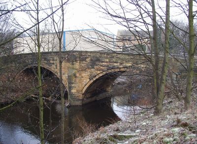
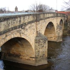
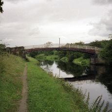
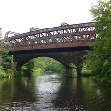
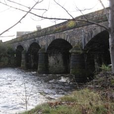
Colne Bridge, grade II listed bridge in the United kingdom

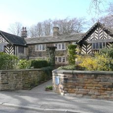
Colne Bridge is a stone arch bridge with two spans that crosses the River Colne in Kirklees. The structure displays simple craftsmanship with stone arches supported by sturdy pillars and continues to serve vehicular and foot traffic today.

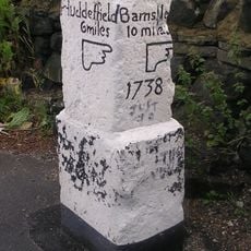
The bridge appears in records dating to at least the 12th century and was built in its current form during the 18th century. It replaced earlier structures and served as a key crossing point for trade and travel between Bradley and Kirkheaton.

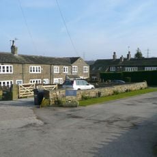
The bridge lends its name to the nearby village that grew around this important crossing. For local residents, it serves as a familiar landmark that reflects the area's historical travel routes and connections.

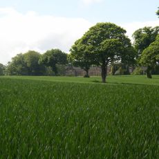
The bridge is free to cross and accessible to pedestrians and vehicles, making it easy to include in a walk through the countryside. The rural setting with fields and trees surrounding the structure creates a quiet spot to stop and observe local history.

Local tradition suggests that the bridge's design may have inspired engineer John Smeaton in his work on London's Blackfriars Bridge. This connection highlights how the structure was considered innovative and well-built for its era.

The community of curious travelers

AroundUs brings together thousands of curated places, local tips, and hidden gems, enriched daily by 60,000 contributors worldwide.

Start exploring
Location
GPS coordinates
53.67750,-1.73330
Latest update
February 9, 2026 11:07
Around this place
Community of the Resurrection
United Kingdom

Community of the Resurrection

1.4 km
Kirklees Priory
United Kingdom

Kirklees Priory

2 km
Kirklees Hall
United Kingdom

Kirklees Hall

2.2 km
Ledgard Bridge
United Kingdom

Ledgard Bridge

2.4 km
Church of St Paul
United Kingdom

Church of St Paul

2.5 km
Church of St John
United Kingdom

Church of St John

2.6 km
Former Church of St Thomas
United Kingdom

Former Church of St Thomas

475 m
Mirfield Library
United Kingdom

Mirfield Library

2.6 km
Kirklees Priory Gatehouse
United Kingdom

Kirklees Priory Gatehouse

2 km
Chestnut Centre Library
United Kingdom

Chestnut Centre Library

2.5 km
Calder And Hebble Navigation Cooper Bridge Lock And Gantry To Foot Bridge
United Kingdom

Calder And Hebble Navigation Cooper Bridge Lock And Gantry To Foot Bridge

436 m
Calder And Hebble Navigation Brearley Bridge  Kirklees Cut Brearley Bridge
United Kingdom

Calder And Hebble Navigation Brearley Bridge Kirklees Cut Brearley Bridge

1.8 km
Mirfield war memorial
United Kingdom

Mirfield war memorial

2.5 km
Bridge Carrying North Track Of Railway Over River Calder Downstream From Kirklees Cut
United Kingdom

Bridge Carrying North Track Of Railway Over River Calder Downstream From Kirklees Cut

1.3 km
Double Aisled Barn To North West Of Kirklees Priory Gatehouse
United Kingdom

Double Aisled Barn To North West Of Kirklees Priory Gatehouse

2 km
Bradley Viaduct
United Kingdom

Bradley Viaduct

556 m
Mirfield Viaduct
United Kingdom

Mirfield Viaduct

2.4 km
Kirkheaton Library
United Kingdom

Kirkheaton Library

1.9 km
Boundary Stone Opposite Three Nuns Public House
United Kingdom

Boundary Stone Opposite Three Nuns Public House

1 km
Home Farm Building Number 9 Malthouse
United Kingdom

Home Farm Building Number 9 Malthouse

2.1 km
Old Milepost At Junction With Hollin Hall Lane
United Kingdom

Old Milepost At Junction With Hollin Hall Lane

1.7 km
Calder And Hebble Navigation Milestone 100 Yards Upstream Of Lower Kirklees Lock  Kirklees Cut Milestone 100 Yards Upstream Of Lower Kirklees Lock
United Kingdom

Calder And Hebble Navigation Milestone 100 Yards Upstream Of Lower Kirklees Lock Kirklees Cut Milestone 100 Yards Upstream Of Lower Kirklees Lock

1.7 km
Firth House
United Kingdom

Firth House

2.8 km
Hopton Hall
United Kingdom

Hopton Hall

2.6 km
Milestone, Leeds Road, opp. No. 17, Mirfield
United Kingdom

Milestone, Leeds Road, opp. No. 17, Mirfield

1.2 km
Milestone, Bradley Road, Bradley
United Kingdom

Milestone, Bradley Road, Bradley

1.3 km
Milestone, Bradley Road,  just E of TI jct with A641
United Kingdom

Milestone, Bradley Road, just E of TI jct with A641

2.7 km
Milestone, by entrance to 866-872 Leeds Road opp Oak Road
United Kingdom

Milestone, by entrance to 866-872 Leeds Road opp Oak Road

557 m
Show the full map
« Colne Bridge - grade II listed bridge in the United kingdom » is provided by Around Us (aroundus.com). Images and texts are derived from Wikimedia project under a Creative Commons license. You are allowed to copy, distribute, and modify copies of this page, under the conditions set by the license, as long as this note is clearly visible.

Discover hidden gems everywhere you go!

From secret cafés to breathtaking viewpoints, skip the crowded tourist spots and find places that match your style. Our app makes it easy with voice search, smart filtering, route optimization, and insider tips from travelers worldwide. Download now for the complete mobile experience.

Around Us App Screenshot

A unique approach to discovering new places

Le Figaro

All the places worth exploring

France Info

A tailor-made excursion in just a few clicks

20 Minutes

Around Us
Travel Guide & Maps
Download

Send to your phone

QR Code
1

Open the camera app on your mobile.

2

Point at the QR code with your camera. A notification will appear.

3

Tap the notification to open the link.