Horsford Castle, Medieval castle site in Horsford, England
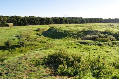
Horsford Castle is a medieval fortification in Norfolk featuring a large earthen mound roughly 77 by 85 meters, with an outer ward extending below it. The entire layout shows the typical design of such castle sites with raised banks and flat interior spaces.
The castle was established after the Norman Conquest in 1066 when William the Conqueror granted the estate to the knight Robert Malet. The property later passed to Walter de Caen, reflecting how lands were redistributed among the new Norman elite.
The fortification displays early Norman military design through its earthen structures, which still reflect medieval defensive methods from the 1000s. Visitors can observe how such castles were built to control the surrounding territory.
The site is accessible via a footpath from the B1149 road, with parking available along the field edges nearby. Entry is open and the grounds are easily walked on foot, though the terrain has slopes and uneven surfaces to navigate.
The fortification contains no visible stonework, suggesting the original structure was built entirely from timber. This building method was common in Norfolk and demonstrates how quickly and practically such defenses could be constructed.
The community of curious travelers
AroundUs brings together thousands of curated places, local tips, and hidden gems, enriched daily by 60,000 contributors worldwide.