Wayford Manor House

Log in to your account

AroundUs is a community-driven map of interesting places, built by curious explorers like you. It grows with every review, story, and photo you share.
Connect to save your favorite spots, contribute locations, and create personalized routes.
Continue with Google
Continue with Apple
Continue with X
Continue with Facebook
Continue with email
By continuing, you accept our Terms and Conditions and our Privacy Policy
Create an account
Add to collection
Map
Suggest a change
Share

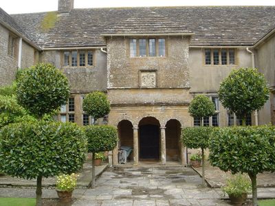
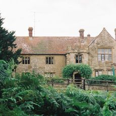
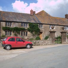
Wayford Manor House, Medieval manor house in Wayford, England.

Wayford Manor House is a manor house in Wayford, England, built around 1600 from stone with traditional windows and period construction methods. The estate features Grade II listed gardens with a Japanese section, rock formations, an orchard, and numerous mature trees throughout the grounds.

Charles Daubeney commissioned the manor house around 1600, with William Arnold serving as the principal mason. The residence was established during a period when English estates were being refashioned with new architectural approaches and formal garden designs.

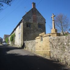
The manor reflects English noble residences through its formal gardens and terraced layouts, which displayed the owner's wealth and social position. These carefully designed outdoor spaces were places where the household spent time and entertained, making them central to daily life and social gatherings.

The estate is straightforward to explore with both indoor areas and extensive garden grounds to walk through. Comfortable shoes are recommended as the terrain includes various surfaces and elevation changes throughout the property.

The adjacent Wayford Woods contain an ornamental lake and numerous small doors installed on trees, known locally as fairy entrances. These whimsical details give the woodland area a sense of playfulness and invite visitors to discover hidden corners.

Location: Wayford

GPS coordinates: 50.85530,-2.84583

Latest update: December 9, 2025 20:20

Photos
Around this place
Crewkerne Castle
United Kingdom

Crewkerne Castle

4.4 km
Church of St Thomas
United Kingdom

Church of St Thomas

3.9 km
Clapton Mill
United Kingdom

Clapton Mill

827 m
Church of St Stephen, Winsham
United Kingdom

Church of St Stephen, Winsham

3.1 km
St Mary's Church, Drimpton
United Kingdom

St Mary's Church, Drimpton

2.1 km
Netherhay Methodist Chapel
United Kingdom

Netherhay Methodist Chapel

1.4 km
Church of St Michael
United Kingdom

Church of St Michael

137 m
Church of St John
United Kingdom

Church of St John

2.5 km
Holy Trinity
United Kingdom

Holy Trinity

3.6 km
Parish Church of St Andrew
United Kingdom

Parish Church of St Andrew

4 km
Parish Church of St Mary
United Kingdom

Parish Church of St Mary

4.4 km
Milestone In East Wall Of Churchyard, About 400 Metres South Of Lych Gate, Church Of St Stephen
United Kingdom

Milestone In East Wall Of Churchyard, About 400 Metres South Of Lych Gate, Church Of St Stephen

3.1 km
Crewkerne War Memorial
United Kingdom

Crewkerne War Memorial

4.4 km
Childhay Manor Farmhouse
United Kingdom

Childhay Manor Farmhouse

2.6 km
First World War Memorial And Retaining Wall Immediately South 50 Metres South Of Church
United Kingdom

First World War Memorial And Retaining Wall Immediately South 50 Metres South Of Church

4.4 km
Higher Farmhouse
United Kingdom

Higher Farmhouse

2.3 km
Cricket House
United Kingdom

Cricket House

3.9 km
Village Cross, About 5 Metres South East Of The George
United Kingdom

Village Cross, About 5 Metres South East Of The George

3.1 km
Littlewindsor Farmhouse
United Kingdom

Littlewindsor Farmhouse

4 km
Boundary Stone Set Into South-East Corner Of The Boundary Wall To Mill House
United Kingdom

Boundary Stone Set Into South-East Corner Of The Boundary Wall To Mill House

814 m
Manor Farmhouse and Attached Front Wall and Gate Piers
United Kingdom

Manor Farmhouse and Attached Front Wall and Gate Piers

3.8 km
Newhaven
United Kingdom

Newhaven

4.4 km
Seaborough Court
United Kingdom

Seaborough Court

2.3 km
Milestone On North East Side Of Junction With Cudworth Lane
United Kingdom

Milestone On North East Side Of Junction With Cudworth Lane

4.5 km
Milestone At Ngr St 3606 0697
United Kingdom

Milestone At Ngr St 3606 0697

4.5 km
Milestone, Horn Ash Crossroads; 3m W of crossroads
United Kingdom

Milestone, Horn Ash Crossroads; 3m W of crossroads

2.2 km
Milestone, near Folly Farm
United Kingdom

Milestone, near Folly Farm

3.4 km
Milestone, E of Maudlin Cross, 60m E of house 'Green View'.
United Kingdom

Milestone, E of Maudlin Cross, 60m E of house 'Green View'.

2.7 km
Show the full map
Reviews

Visited this place? Tap the stars to rate it and share your experience / photos with the community! Try now! You can cancel it anytime.

« Wayford Manor House - Medieval manor house in Wayford, England » is provided by Around Us (aroundus.com). Images and texts are derived from Wikimedia project under a Creative Commons license. You are allowed to copy, distribute, and modify copies of this page, under the conditions set by the license, as long as this note is clearly visible.

Discover hidden gems everywhere you go!

From secret cafés to breathtaking viewpoints, skip the crowded tourist spots and find places that match your style. Our app makes it easy with voice search, smart filtering, route optimization, and insider tips from travelers worldwide. Download now for the complete mobile experience.

Around Us App Screenshot

A unique approach to discovering new places

Le Figaro

All the places worth exploring

France Info

A tailor-made excursion in just a few clicks

20 Minutes