Enable Location

We need your location to show you interesting places around you

Discover nearby places

Find interesting locations and hidden gems around you

Precise directions

Get accurate directions and distances to places

Your location is never shared with other users. It's only used when you tap the location button.

Whiteway House

Log in to your account

Start exploring — it's free

Trusted by 63,005 travelers worldwide

Continue with Google
Continue with Apple
or

We will send you a code to connect

By continuing, you accept our Terms and Conditions and our Privacy Policy

Check your inbox

We've sent a pincode in your inbox. Please enter the code below.

Whiteway House
Discussion Reviews 1 Photos
2.9k Popularity

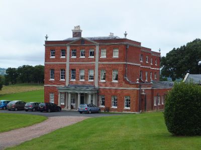
Whiteway House, Grade II* listed Georgian house in Chudleigh, England

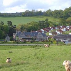
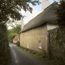
Whiteway House is a Georgian country house built in the 1770s in Chudleigh, set near the base of Haldon Hills. The building shows a symmetrical front made with local Devon stone, though parts including a north-east wing were removed during later changes after the 1960s.

The house was built in the 1770s by John Parker, 1st Baron Boringdon, who also managed the major Saltram estate nearby in Plympton. This period represented the height of Georgian country house building before the property underwent changes in later centuries.

The design reflects how wealthy English landowners of the 1700s liked to build their country homes. The choices made in its construction tell a story about what these families valued in their estates.

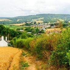
The house is located in Chudleigh within a hilly area and can be reached by local roads through the village. Visitors should check in advance whether the building can be viewed, as it remains privately owned.

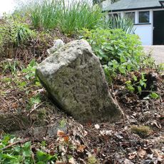
A stone memorial in Chudleigh Church records the Bennett family name across generations linked to this house. This inscription shows how the family maintained their connection to the place over a long span of time.

The community of curious travelers

AroundUs brings together thousands of curated places, local tips, and hidden gems, enriched daily by 60,000 contributors worldwide.

Start exploring
Location
GPS coordinates
50.63530,-3.58970
Latest update
December 12, 2025 12:06
Around this place
Haldon Hills
United Kingdom

Haldon Hills

2.9 km
Haldon Belvedere
United Kingdom

Haldon Belvedere

3.2 km
Hams Barton
United Kingdom

Hams Barton

2.7 km
The Town Hall
United Kingdom

The Town Hall

3.4 km
Church of Saint Michael
United Kingdom

Church of Saint Michael

2.2 km
Church of St John the Baptist
United Kingdom

Church of St John the Baptist

2.7 km
Chudleigh War Memorial
United Kingdom

Chudleigh War Memorial

3.5 km
Crideford Inn
United Kingdom

Crideford Inn

2.2 km
The Old Coaching House
United Kingdom

The Old Coaching House

3.6 km
Trusham War Memorial
United Kingdom

Trusham War Memorial

2.6 km
The Post Office
United Kingdom

The Post Office

3.5 km
Forge Cottage
United Kingdom

Forge Cottage

3.5 km
Rustic Bridge In The Woodland About 10 Metres North East Of Haldon Gate
United Kingdom

Rustic Bridge In The Woodland About 10 Metres North East Of Haldon Gate

3 km
Lyalls Cottage
United Kingdom

Lyalls Cottage

3.4 km
Direction Post On North-West Side Of Road To Crockham Bridge, About 5 Metres From Junction With B3193
United Kingdom

Direction Post On North-West Side Of Road To Crockham Bridge, About 5 Metres From Junction With B3193

3.4 km
Harcombe House Including Steps At The Rear
United Kingdom

Harcombe House Including Steps At The Rear

1.7 km
Milestone 139m N of Rookery Nook
United Kingdom

Milestone 139m N of Rookery Nook

3.6 km
K6 Telephone Kiosks Outside Town Hall
United Kingdom

K6 Telephone Kiosks Outside Town Hall

3.4 km
Spara Bridge
United Kingdom

Spara Bridge

3.5 km
The Obelisk
United Kingdom

The Obelisk

3.5 km
Garden And Farmyard Walls To The South West And South Of Place Barton Including And Footbridge Over Shippen Brook And Thatched Building West Of Place Barton
United Kingdom

Garden And Farmyard Walls To The South West And South Of Place Barton Including And Footbridge Over Shippen Brook And Thatched Building West Of Place Barton

2.8 km
Lyalls
United Kingdom

Lyalls

3.3 km
Crammers Farmhouse
United Kingdom

Crammers Farmhouse

2.1 km
Milestone 130m N of Harcombe Cross Petrol Station
United Kingdom

Milestone 130m N of Harcombe Cross Petrol Station

1.4 km
7, Fore Street
United Kingdom

7, Fore Street

3.5 km
Milestone, Great Haldon Hill, N bound carriageway, 750m S of service station, by barrier marker 105 /2
United Kingdom

Milestone, Great Haldon Hill, N bound carriageway, 750m S of service station, by barrier marker 105 /2

1.7 km
Milestone, Harcombe Garage, 30m E of entrance
United Kingdom

Milestone, Harcombe Garage, 30m E of entrance

1.4 km
Milestone, 250m N of Mamhead Cross
United Kingdom

Milestone, 250m N of Mamhead Cross

3.3 km
Show the full map
Reviews
Share your experience

No review yet

Discussions
Start a discussion...

No discussion yet

« Whiteway House - Grade II* listed Georgian house in Chudleigh, England » is provided by Around Us (aroundus.com). Images and texts are derived from Wikimedia project under a Creative Commons license. You are allowed to copy, distribute, and modify copies of this page, under the conditions set by the license, as long as this note is clearly visible.

Discover hidden gems everywhere you go!

From secret cafés to breathtaking viewpoints, skip the crowded tourist spots and find places that match your style. Our app makes it easy with voice search, smart filtering, route optimization, and insider tips from travelers worldwide. Download now for the complete mobile experience.

Around Us App Screenshot

A unique approach to discovering new places

Le Figaro

All the places worth exploring

France Info

A tailor-made excursion in just a few clicks

20 Minutes

Around Us
Travel Guide & Maps
Download

Send to your phone

QR Code
1

Open the camera app on your mobile.

2

Point at the QR code with your camera. A notification will appear.

3

Tap the notification to open the link.