Chest opened
+${chestReward.xp} XP
Explorer
NOUVEAU ×${chestReward.collectible.quantity}
tapez pour fermer
Chest locked

Open chests in the app

Around Us is built for your phone — chests unlock when you walk, explore and capture nearby places.

Enable Location

We need your location to show you interesting places around you

Discover nearby places

Find interesting locations and hidden gems around you

Precise directions

Get accurate directions and distances to places

Your location is never shared with other users. It's only used when you tap the location button.

North Wyke

Log in to your account

Start exploring — it's free

Trusted by 72,892 travelers worldwide

Continue with Google
Continue with Apple
or

We will send you a code to connect

By continuing, you accept our Terms and Conditions and our Privacy Policy

Check your inbox

We've sent a pincode in your inbox. Please enter the code below.

Discussion Reviews 1 Photos
1.6k Popularity

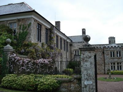
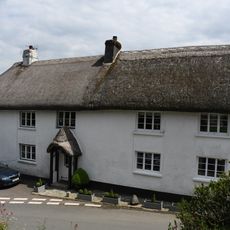
North Wyke, Grade I listed building in South Tawton, England.

North Wyke is a medieval manor house in South Tawton with stone walls and traditional features typical of its period. The building retains its original layout and characteristic construction elements from its era.

The estate came under the family's control in the 13th century, originally named de Wray before changing their surname during Richard II's reign. They maintained ownership until 1714, when the property passed out of family hands.

The Wyke family name remains woven into the local identity, reflecting their centuries-long presence and influence in the area. Villagers still recognize the connection between the family and the manor as part of the region's heritage.

The manor now houses offices and laboratory facilities used for agricultural research at Rothamsted Research. Access to the building may be limited since it remains an active research facility.

One family member became involved in questionable dealings and fraudulent documents in 1670, earning a dubious reputation. This episode reveals the kinds of schemes that could entangle even prominent landowners of the time.

The community of curious travelers

AroundUs brings together thousands of curated places, local tips, and hidden gems, enriched daily by 60,000 contributors worldwide.

Start exploring
Location
GPS coordinates
50.76950,-3.90134
Latest update
December 14, 2025 14:25
Around this place
Town Hall Including Area Railings At Front
United Kingdom

Town Hall Including Area Railings At Front

3.4 km
Church of St Andrew
United Kingdom

Church of St Andrew

4 km
Church of St Peter
United Kingdom

Church of St Peter

3.4 km
Taw Green Bridge
United Kingdom

Taw Green Bridge

1.6 km
Oxenham Cross
United Kingdom

Oxenham Cross

4 km
Blackhall Manor Farmhouse
United Kingdom

Blackhall Manor Farmhouse

3.9 km
Clock Tower
United Kingdom

Clock Tower

3.4 km
Church View Cottage And Beggars Roost
United Kingdom

Church View Cottage And Beggars Roost

4 km
2 Adjacent Chest Tombs Approximately 2.5 Metres South Of Aisle Of Church Of St Andrew
United Kingdom

2 Adjacent Chest Tombs Approximately 2.5 Metres South Of Aisle Of Church Of St Andrew

4 km
Park Cottage, Maltsters, Little Thatch And Rose Cottage
United Kingdom

Park Cottage, Maltsters, Little Thatch And Rose Cottage

3.9 km
Wayside cross in Sampford Courtenay village 55m NNW of Cherrywell Cottages
United Kingdom

Wayside cross in Sampford Courtenay village 55m NNW of Cherrywell Cottages

3.6 km
Week Barn Cross
United Kingdom

Week Barn Cross

3.2 km
3 Adjacent Chest Tombs Approximately 1.5 Metres South East Of Porch Of Church Of St Andrew
United Kingdom

3 Adjacent Chest Tombs Approximately 1.5 Metres South East Of Porch Of Church Of St Andrew

4 km
Stracheye Headstone Approximately 15 Metres West Of South Aisle Of Church Of St Andrew
United Kingdom

Stracheye Headstone Approximately 15 Metres West Of South Aisle Of Church Of St Andrew

4 km
Ballis Chest Tomb Approximately 3 Metres South Of Porch Of Church Of St Andrew
United Kingdom

Ballis Chest Tomb Approximately 3 Metres South Of Porch Of Church Of St Andrew

4 km
2 Oades Headstones Approximately 15 Metres West Of North Aisle Of Church Of St Andrew
United Kingdom

2 Oades Headstones Approximately 15 Metres West Of North Aisle Of Church Of St Andrew

4 km
Oxenham Chest Tomb Approximately 6 Metres South Of Aisle Of Church Of St Andrew
United Kingdom

Oxenham Chest Tomb Approximately 6 Metres South Of Aisle Of Church Of St Andrew

4 km
Illegible Headstone Approximately 45 Metres North Of Church Of St Andrew
United Kingdom

Illegible Headstone Approximately 45 Metres North Of Church Of St Andrew

3.9 km
Lych Gate And Stile To Churchyard Of Church Of St Andrew
United Kingdom

Lych Gate And Stile To Churchyard Of Church Of St Andrew

4 km
Wayside cross at Trecott beside Wellsprings Lane
United Kingdom

Wayside cross at Trecott beside Wellsprings Lane

3.1 km
Coss Headstone Approximately 10 Metres North Of Aisle Of Church Of St Andrew
United Kingdom

Coss Headstone Approximately 10 Metres North Of Aisle Of Church Of St Andrew

3.9 km
Lethbridge Headstone Approximately 8 Metres South Of Aisle Of Church Of St Andrew
United Kingdom

Lethbridge Headstone Approximately 8 Metres South Of Aisle Of Church Of St Andrew

4 km
Melcland Chest Tomb Approximately 3 Metres North Of Church Of St Andrew
United Kingdom

Melcland Chest Tomb Approximately 3 Metres North Of Church Of St Andrew

4 km
Row Of 7 Headstones Approximately 4 Metres West Of Tower Of Church Of St Andrew
United Kingdom

Row Of 7 Headstones Approximately 4 Metres West Of Tower Of Church Of St Andrew

4 km
Tapp Headstone Approximately 3 Metres North Of Aisle Of Church Of St Andrew
United Kingdom

Tapp Headstone Approximately 3 Metres North Of Aisle Of Church Of St Andrew

4 km
Damerel Headstone Approximately 5 Metres North Of Tower Of Church Of St Andrew
United Kingdom

Damerel Headstone Approximately 5 Metres North Of Tower Of Church Of St Andrew

4 km
Dey Headstone Approximately 18 Metres West Of South Aisle Of Church Of St Andrew
United Kingdom

Dey Headstone Approximately 18 Metres West Of South Aisle Of Church Of St Andrew

4 km
Market Cross
United Kingdom

Market Cross

3.4 km
Show the full map
Reviews
Share your experience

No review yet

Discussions
Start a discussion...

No discussion yet

« North Wyke - Grade I listed building in South Tawton, England » is provided by Around Us (aroundus.com). Images and texts are derived from Wikimedia project under a Creative Commons license. You are allowed to copy, distribute, and modify copies of this page, under the conditions set by the license, as long as this note is clearly visible.

Discover hidden gems everywhere you go!

From secret cafés to breathtaking viewpoints, skip the crowded tourist spots and find places that match your style. Our app makes it easy with voice search, smart filtering, route optimization, and insider tips from travelers worldwide. Download now for the complete mobile experience.

Around Us App Screenshot

A unique approach to discovering new places

Le Figaro

All the places worth exploring

France Info

A tailor-made excursion in just a few clicks

20 Minutes

Around Us
Travel Guide & Maps
Download

Send to your phone

QR Code
1

Open the camera app on your mobile.

2

Point at the QR code with your camera. A notification will appear.

3

Tap the notification to open the link.