Enable Location

We need your location to show you interesting places around you

Discover nearby places

Find interesting locations and hidden gems around you

Precise directions

Get accurate directions and distances to places

Your location is never shared with other users. It's only used when you tap the location button.

Royds Hall

Log in to your account

Start exploring — it's free

Trusted by 64,890 travelers worldwide

Continue with Google
Continue with Apple
or

We will send you a code to connect

By continuing, you accept our Terms and Conditions and our Privacy Policy

Check your inbox

We've sent a pincode in your inbox. Please enter the code below.

Royds Hall
Discussion Reviews 1 Photos
4.4k Popularity

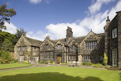
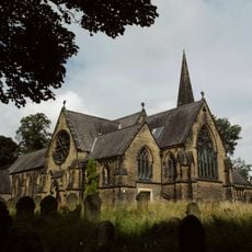
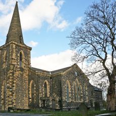
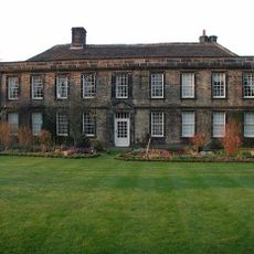
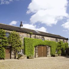
Royds Hall, Grade II* listed manor house in Low Moor, Bradford, England.

Royds Hall is a stone manor house in Low Moor, a district of Bradford in West Yorkshire, England, built with a symmetrical front and a cross-wing layout. Outbuildings from the 1600s and walled gardens with lawns complete the grounds, giving the property the overall shape of a traditional English country estate.

The building started as a timber-framed structure in 1458 and changed considerably over the next few centuries. A stone facing was added in 1640, and an eastern wing followed in 1770, each addition reflecting the priorities of the owners at the time.

Royds Hall sits in an area shaped by the wool and textile trades, and the house reflects the kind of home that successful landowners in West Yorkshire built to show their standing. Walking around the exterior, visitors can see how local stone and garden design were used to express prosperity in a working industrial region.

The manor house can be seen from the outside, but the interior is not open to visitors. A visit in daylight gives the clearest view of the stonework and the layout of the gardens surrounding the property.

A large earthenware jar filled with gold coins, thought to date from the English Civil War in the mid-1600s, was found by a farmer on a nearby farm. The discovery suggests someone buried their wealth in a hurry during that troubled period and never returned to collect it.

The community of curious travelers

AroundUs brings together thousands of curated places, local tips, and hidden gems, enriched daily by 60,000 contributors worldwide.

Start exploring
Location
GPS coordinates
53.75020,-1.78377
Latest update
March 3, 2026 08:10
Around this place
St Michael and All Angels Church, Shelf, West Yorkshire
United Kingdom

St Michael and All Angels Church, Shelf, West Yorkshire

1.7 km
Bethel Methodist Church
United Kingdom

Bethel Methodist Church

1.7 km
Church of St Mary the Virgin
United Kingdom

Church of St Mary the Virgin

1.7 km
Church of St Mark
United Kingdom

Church of St Mark

952 m
Wyke Viaduct
United Kingdom

Wyke Viaduct

2.2 km
Church of St Paul
United Kingdom

Church of St Paul

1.6 km
Church of St John
United Kingdom

Church of St John

2.3 km
Church of the Holy Trinity
United Kingdom

Church of the Holy Trinity

1.8 km
The Old White Beare Inn
United Kingdom

The Old White Beare Inn

1.3 km
The former Hare and Hounds Public House, Wibsey Bank
United Kingdom

The former Hare and Hounds Public House, Wibsey Bank

2.3 km
The Upper George Public House
United Kingdom

The Upper George Public House

1.9 km
Wibsey Library
United Kingdom

Wibsey Library

1.8 km
Milestone At Ngr Se 145260
United Kingdom

Milestone At Ngr Se 145260

2.2 km
Wyke Library
United Kingdom

Wyke Library

1.2 km
The Kings Head Public House And Coach House/Stable Adjoining To Right
United Kingdom

The Kings Head Public House And Coach House/Stable Adjoining To Right

1.1 km
Bottom Hall Viaduct
United Kingdom

Bottom Hall Viaduct

2.3 km
6-12, Beck Hill
United Kingdom

6-12, Beck Hill

1.4 km
8-11, Beehive Street
United Kingdom

8-11, Beehive Street

1.1 km
Main Block To Hill Top Primary School
United Kingdom

Main Block To Hill Top Primary School

1.1 km
Shelf Library
United Kingdom

Shelf Library

2.2 km
Junction House
United Kingdom

Junction House

1.6 km
Coley Hall
United Kingdom

Coley Hall

1.9 km
Lt F. W. Milligan Memorial, Low Moor, Bradford
United Kingdom

Lt F. W. Milligan Memorial, Low Moor, Bradford

1 km
Main L Shaped Block Of Stable, Coach House And Barn Enclosing The Court To North Of The Hall Outbuildings At Royds Hall
United Kingdom

Main L Shaped Block Of Stable, Coach House And Barn Enclosing The Court To North Of The Hall Outbuildings At Royds Hall

47 m
Main Building To South At Buttershaw Mill, Fronting Road
United Kingdom

Main Building To South At Buttershaw Mill, Fronting Road

1.2 km
Milestone, Carr House Road;Buttershaw
United Kingdom

Milestone, Carr House Road;Buttershaw

1.5 km
Low Moor War Memorial, Bradford
United Kingdom

Low Moor War Memorial, Bradford

1.6 km
Wibsey Garden of Remembrance
United Kingdom

Wibsey Garden of Remembrance

2.1 km
Show the full map
Reviews
Share your experience

No review yet

Discussions
Start a discussion...

No discussion yet

« Royds Hall - Grade II* listed manor house in Low Moor, Bradford, England » is provided by Around Us (aroundus.com). Images and texts are derived from Wikimedia project under a Creative Commons license. You are allowed to copy, distribute, and modify copies of this page, under the conditions set by the license, as long as this note is clearly visible.

Discover hidden gems everywhere you go!

From secret cafés to breathtaking viewpoints, skip the crowded tourist spots and find places that match your style. Our app makes it easy with voice search, smart filtering, route optimization, and insider tips from travelers worldwide. Download now for the complete mobile experience.

Around Us App Screenshot

A unique approach to discovering new places

Le Figaro

All the places worth exploring

France Info

A tailor-made excursion in just a few clicks

20 Minutes

Around Us
Travel Guide & Maps
Download

Send to your phone

QR Code
1

Open the camera app on your mobile.

2

Point at the QR code with your camera. A notification will appear.

3

Tap the notification to open the link.