The Yelde Hall And The Council Chamber

Log in to your account

AroundUs is a community-driven map of interesting places, built by curious explorers like you. It grows with every review, story, and photo you share.
Connect to save your favorite spots, contribute locations, and create personalized routes.
Continue with Google
Continue with Apple
Continue with X
Continue with Facebook
Continue with email
By continuing, you accept our Terms and Conditions and our Privacy Policy
Create an account

The Yelde Hall And The Council Chamber

Add to collection
Map
Suggest a change
Share

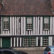
The Yelde Hall And The Council Chamber, Medieval civic building in Market Place, Chippenham, England

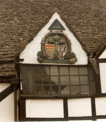
The Yelde Hall is a timber-framed building on the Market Place with an asymmetrical two-bay frontage and carved town arms dated 1776 on its left gable. The cellar originally held prisoners, the ground floor served as a courtroom, and the upper floor housed the council chamber.

Built around 1450, it stands as evidence of the middle of the 15th century when growing towns needed dedicated spaces for managing justice and civic affairs. Its later use by military regiments shows how the building adapted to changing needs over several centuries.

The name comes from a medieval term for a guild hall, reflecting its role as the heart of town administration and justice. Today visitors can see how the different rooms were used, revealing what mattered most to people in this community centuries ago.

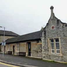
Following its renovation in 2012, visitors can explore local history exhibitions and join guided tours to learn about the different levels and their original uses. Plan enough time to take in the timber details and carvings that give the rooms their character.

The transformation of the cellar jail space reveals how medieval buildings combined multiple functions in one structure, something rarely visible so clearly in one place. This practical approach to town planning is still readable in how the rooms are divided, making it a rare example of how medieval people solved real problems with clever design.

Location: Chippenham

Inception: 1450

GPS coordinates: 51.45800,-2.11391

Latest update: December 14, 2025 18:43

Photos
Around this place
Church of St Andrew
United Kingdom

Church of St Andrew

98 m
Chippenham Town Hall
United Kingdom

Chippenham Town Hall

169 m
Angel Hotel
United Kingdom

Angel Hotel

58 m
Chippenham Museum
United Kingdom

Chippenham Museum

67 m
Church of St Paul
United Kingdom

Church of St Paul

789 m
Green Bridge (MLN1/93 03)
United Kingdom

Green Bridge (MLN1/93 03)

1.7 km
The Three Crowns Public House
United Kingdom

The Three Crowns Public House

373 m
11 Market Place, Chippenham
United Kingdom

11 Market Place, Chippenham

75 m
Palace Theatre
United Kingdom

Palace Theatre

429 m
Two Chapels And Gateway, Chippenham Cemetery
United Kingdom

Two Chapels And Gateway, Chippenham Cemetery

1.4 km
The Bear Hotel
United Kingdom

The Bear Hotel

67 m
Reel Cinema
United Kingdom

Reel Cinema

596 m
Chippenham War Memorial
United Kingdom

Chippenham War Memorial

39 m
Chippenham Library
United Kingdom

Chippenham Library

85 m
The Pheasant Public House
United Kingdom

The Pheasant Public House

1.9 km
Zealys House
United Kingdom

Zealys House

154 m
Chippenham Station, Entrance Building And Attached Platform Canopies
United Kingdom

Chippenham Station, Entrance Building And Attached Platform Canopies

498 m
Chippenham Railway Viaduct
United Kingdom

Chippenham Railway Viaduct

511 m
Number 51 And Attached Walls And Gate Piers
United Kingdom

Number 51 And Attached Walls And Gate Piers

1.1 km
Railway Bridge Over Bath Road
United Kingdom

Railway Bridge Over Bath Road

1.5 km
Milestone About 100 Metres North West Of Junction With Old Hardenhuish Lane
United Kingdom

Milestone About 100 Metres North West Of Junction With Old Hardenhuish Lane

1.9 km
The Woodhouse
United Kingdom

The Woodhouse

160 m
Milestone About 25 Metres South East Of Gate Farmhouse
United Kingdom

Milestone About 25 Metres South East Of Gate Farmhouse

1.7 km
Front And Main Rear Range Of St Andrews Hospital And Attached Walls
United Kingdom

Front And Main Rear Range Of St Andrews Hospital And Attached Walls

1.1 km
Milestone, Malmesbury Road; 30m S jcn Hill Corner Road outside King Alfred pub
United Kingdom

Milestone, Malmesbury Road; 30m S jcn Hill Corner Road outside King Alfred pub

1.7 km
Gate Farmhouse
United Kingdom

Gate Farmhouse

1.7 km
The Old Vicarage And Attached Railings
United Kingdom

The Old Vicarage And Attached Railings

143 m
Milestone, Rowden Hill; 20m NE of jct with Lowden
United Kingdom

Milestone, Rowden Hill; 20m NE of jct with Lowden

1.1 km
Show the full map
Reviews

Visited this place? Tap the stars to rate it and share your experience / photos with the community! Try now! You can cancel it anytime.

« The Yelde Hall And The Council Chamber - Medieval civic building in Market Place, Chippenham, England » is provided by Around Us (aroundus.com). Images and texts are derived from Wikimedia project under a Creative Commons license. You are allowed to copy, distribute, and modify copies of this page, under the conditions set by the license, as long as this note is clearly visible.

Discover hidden gems everywhere you go!

From secret cafés to breathtaking viewpoints, skip the crowded tourist spots and find places that match your style. Our app makes it easy with voice search, smart filtering, route optimization, and insider tips from travelers worldwide. Download now for the complete mobile experience.

Around Us App Screenshot

A unique approach to discovering new places

Le Figaro

All the places worth exploring

France Info

A tailor-made excursion in just a few clicks

20 Minutes