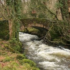
Holne Bridge, Medieval road bridge in Ashburton, England
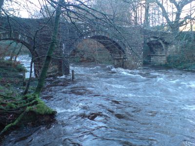
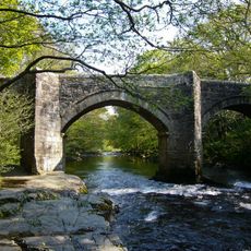
Holne Bridge is a stone road bridge that crosses the River Dart with four arches, three semicircular and one segmental in shape. The structure is protected on both sides by cutwaters that shield the stonework from floodwaters.
The bridge took its current form in 1413 after a flood destroyed the earlier structure, with Bishop Stafford issuing indulgences to raise money for rebuilding. This medieval design has endured through the centuries since then.
The bridge shaped life in both Holne and Ashburton, serving as the main crossing point where people from both communities met and traded for centuries. Today it remains a focal point where locals and visitors naturally gather while moving between the two villages.
The narrow deck restricts large vehicles, but pedestrian refuges built into the north-side cutwaters provide safe crossing points. When visiting, expect foot traffic and take care if driving a small vehicle across.
The structure serves as an official control point for water sports, marking the boundary between two paddling sections of the Dart. Kayakers and canoeists use this location as a key landmark during their river journeys.
Location: Ashburton
Location: Holne
Made from material: granite
GPS coordinates: 50.52120,-3.79266
Latest update: December 14, 2025 13:00
Newbridge
1.9 km
Hembury Castle
2.2 km
Ashburton Town Hall
2.6 km
Church House Inn
2.6 km
Church of St Andrew
2.6 km
Exeter Inn
2.6 km
The Victoria Inn
2.4 km
Buckland Bridge
1.8 km
Ruddycleave Cottage
2.6 km
Engine House And Chimney At Druid Copper Mine
1.8 km
32, 32a And 32b Including Detached Rear Building
2.6 km
Terrace House
2.4 km
Little Brook
2.4 km
Earthworks in Boro' Wood
2.1 km
Gates, Piers, Railings, Boundary Wall And Conduit Head On North Of Churchyard
2.6 km
Drinking Fountain 17 Metres North Of No 66
2.5 km
Barn At Engine House About 40 Metres South East Of Southbrook Farmhouse
2.4 km
Higher Headborough Farmhouse
2 km
Spitchwick Lower Lodges
1.8 km
Southbrook Farmhouse
2.4 km
42, West Street
2.6 km
50, North Street
2.5 km
St Gudula's Cross
2.6 km
Milestone At Sx 7480 7135 On South West Side Of Road
1.9 km
Milestone Approximately 100 Metres South Of Gage's Mill
2.4 km
Card House
2.6 km
Lower Lodge
1.7 km
Guidestone, Stoney Post Cross, Gallantry Bower, 100m S of Chase Gate Farm
1.3 kmVisited this place? Tap the stars to rate it and share your experience / photos with the community! Try now! You can cancel it anytime.
Discover hidden gems everywhere you go!
From secret cafés to breathtaking viewpoints, skip the crowded tourist spots and find places that match your style. Our app makes it easy with voice search, smart filtering, route optimization, and insider tips from travelers worldwide. Download now for the complete mobile experience.
A unique approach to discovering new places❞
— Le Figaro
All the places worth exploring❞
— France Info
A tailor-made excursion in just a few clicks❞
— 20 Minutes