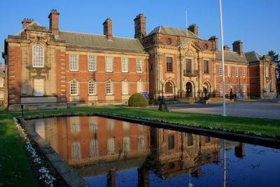
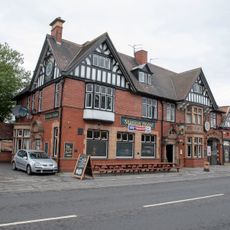
County Hall, County hall and Grade II* listed building in Romanby, England
County Hall is an administrative building in Romanby with a square courtyard plan, a main front of 15 bays, and 23 bay returns. It was constructed from ashlar stone and red brick and continues to serve as the headquarters for North Yorkshire County Council.
The building was designed and built between 1904 and 1914 by architect W. H. Brierley in Neo-Wren style for the North Riding of Yorkshire County Council. This period saw local authorities across England commissioning grand new administrative centers to reflect their growing importance.
The council chamber displays Baroque elements with a domed ceiling supported by Corinthian columns that create a sense of dignity and authority. These interior details reflect the importance placed on local governance when the building was created.
The building sits on Boroughbridge Road and is easy to spot from the street. Since it continues to function as the county council headquarters, you can appreciate the exterior architecture from public areas, though interior access may vary depending on official activities.
The main staircase leads to an upper landing decorated with intricate plasterwork and features a statue of Samson. The corridors are lined with black and white marble floor patterns that create striking visual contrasts throughout the building.
The community of curious travelers
AroundUs brings together thousands of curated places, local tips, and hidden gems, enriched daily by 60,000 contributors worldwide.