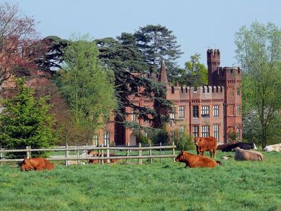
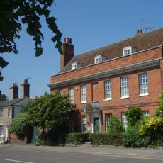
Faulkbourne Hall, Manor house in Faulkbourne, England.
Faulkbourne Hall is a red-brick manor house featuring multiple turrets and decorative flags displaying family initials across its varied architectural elements. The structure stands within a Grade II listed park and garden setting that encompasses the religious building on its grounds.
The manor received permission to convert from timber-frame to brick construction in 1439, marking a shift toward more durable building methods. This transformation established the structural foundation that would endure for centuries.
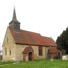
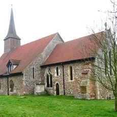
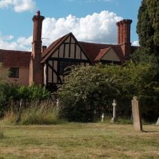
The parish church of Saint Germanus located within the grounds reflects the hall's long connection to local religious life and community gatherings.
The hall is located roughly 8 kilometers southeast of Braintree near the A12 and B1018 roads, making it accessible by car. Visiting the parkland setting requires advance planning as the property may have limited public access during certain periods.
The roof displays metal flag vanes shaped with family initials that were installed during the 260 years of Bullock family ownership. These decorative touches remain a distinctive visual reminder of the family's long stewardship over the property.
Location: Faulkbourne
GPS coordinates: 51.81750,0.61399
Latest update: December 9, 2025 20:20
Cressing Temple
2.3 km
Parish Church of St Germanus
274 m
61, Newland Street
2.7 km
Church of St Nicolas
1.8 km
Church of St Ethelreda
2.5 km
Red Lion Inn
2.7 km
Church of St Mary and All Saints
2.9 km
Parish Church of All Saints
3.4 km
Statue of Dorothy L. Sayers
2.7 km
All Saints Church
2.5 km
House At Rear Of White Hart Hotel White Hart Hotel
2.7 km
Witham Library
2.6 km
Witham United Reformed Church
2.7 km
Woolpack Inn
1.8 km
The Barley Barn
2.4 km
George Inn
2.6 km
Spread Eagle Hotel
2.7 km
Terling Stores And Post Office
3.3 km
White Horse Public House
1.9 km
Witham Cross of Remembrance
2.6 km
The Wheat Barn
2.4 km
St Francis' Church
3.3 km
Avenue House Newbury House
2.6 km
Tudor House
3.3 km
The Cross Keys
2.6 km
Granary/Stables Block 70 Metres South Of Cressing Temple Farmhouse
2.2 km
Coach House To North East Of Fambridge Hall
2.8 km
Milepost, Colchester Road, Eastways, opp. Critall Road industrial area
2.7 kmVisited this place? Tap the stars to rate it and share your experience / photos with the community! Try now! You can cancel it anytime.
Discover hidden gems everywhere you go!
From secret cafés to breathtaking viewpoints, skip the crowded tourist spots and find places that match your style. Our app makes it easy with voice search, smart filtering, route optimization, and insider tips from travelers worldwide. Download now for the complete mobile experience.
A unique approach to discovering new places❞
— Le Figaro
All the places worth exploring❞
— France Info
A tailor-made excursion in just a few clicks❞
— 20 Minutes