Enable Location

We need your location to show you interesting places around you

Discover nearby places

Find interesting locations and hidden gems around you

Precise directions

Get accurate directions and distances to places

Your location is never shared with other users. It's only used when you tap the location button.

Parish Church of St Mary and St Giles

Log in to your account

Start exploring — it's free

Trusted by 63,029 travelers worldwide

Continue with Google
Continue with Apple
or

We will send you a code to connect

By continuing, you accept our Terms and Conditions and our Privacy Policy

Check your inbox

We've sent a pincode in your inbox. Please enter the code below.

Parish Church of St Mary and St Giles
Discussion Reviews 1 Photos
1.7k Popularity

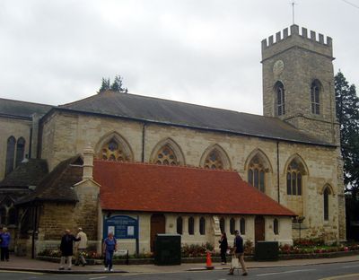
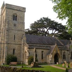
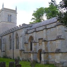
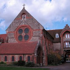
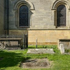
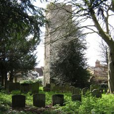
Parish Church of St Mary and St Giles, Grade II* listed church building in Stony Stratford, England

The Parish Church of St Mary and St Giles is a Grade II* listed building in Stony Stratford with a church interior featuring slender fluted columns supporting the nave. The structure includes a ribbed vaulted ceiling and a 15th-century tower that remains a focal point of the town.

A major fire in 1742 destroyed most of the structure while the tower survived the flames. Architect Francis Hiorne oversaw the rebuilding, completing the reconstruction by 1777 and establishing the church's present appearance.

The merger of two parishes in 1968 resulted in the reconsecration of St Giles as the joint church of St Mary and St Giles, marking a significant change in local religious organization.

The building is readily accessible with parking available nearby, making visits straightforward and convenient for most people. Opening times accommodate regular visitors and those attending community gatherings held throughout the year.

The church sits along the historic Roman Watling Street, positioning it as a spiritual meeting point for passing travelers in medieval times. Two separate chapels were established by neighboring manors to serve this important function.

The community of curious travelers

AroundUs brings together thousands of curated places, local tips, and hidden gems, enriched daily by 60,000 contributors worldwide.

Start exploring
Location
Inception
1776
Architects
Francis Hiorne
GPS coordinates
52.05700,-0.85355
Latest update
December 14, 2025 13:08
Around this place
Church of All Saints
United Kingdom

Church of All Saints

1.5 km
Church of St Guthlac, Passenham
United Kingdom

Church of St Guthlac, Passenham

1.2 km
Church of St Mary
United Kingdom

Church of St Mary

352 m
Former St Anthonys Franciscan Preparatory School
United Kingdom

Former St Anthonys Franciscan Preparatory School

304 m
The Plough Inn
United Kingdom

The Plough Inn

258 m
The Cock Hotel
United Kingdom

The Cock Hotel

58 m
The Bull Hotel
United Kingdom

The Bull Hotel

35 m
The Old George
United Kingdom

The Old George

71 m
Stony Stratford War Memorial Cross
United Kingdom

Stony Stratford War Memorial Cross

299 m
The Crown Public House
United Kingdom

The Crown Public House

134 m
Old Wolverton Mill
United Kingdom

Old Wolverton Mill

1 km
Bridge Over River Ouse (That Part In Old Stratford Civil Parish)
United Kingdom

Bridge Over River Ouse (That Part In Old Stratford Civil Parish)

760 m
The Manor House And Attached Walls And Gates
United Kingdom

The Manor House And Attached Walls And Gates

1.2 km
Two Chest Tombs To The South Of The Nave Of The Church Of The Holy Trinity
United Kingdom

Two Chest Tombs To The South Of The Nave Of The Church Of The Holy Trinity

1.8 km
St Mary's Parish Hall
United Kingdom

St Mary's Parish Hall

331 m
Working Men's Social Club
United Kingdom

Working Men's Social Club

324 m
Manor Farmhouse
United Kingdom

Manor Farmhouse

1.1 km
Milepost, Stratford Road; Wolverton Mill, by Wolverton Park, opp. Mill End, 100m W of double mini-roundabout
United Kingdom

Milepost, Stratford Road; Wolverton Mill, by Wolverton Park, opp. Mill End, 100m W of double mini-roundabout

1.6 km
Longueville Court
United Kingdom

Longueville Court

1.8 km
Remains of the church and churchyard of St Mary Magdalen
United Kingdom

Remains of the church and churchyard of St Mary Magdalen

216 m
Methodist Church And Church Hall
United Kingdom

Methodist Church And Church Hall

178 m
Barn And Coach House To East Of Old Wolverton Mill
United Kingdom

Barn And Coach House To East Of Old Wolverton Mill

1 km
Wolverton Park
United Kingdom

Wolverton Park

1.6 km
Tower House
United Kingdom

Tower House

193 m
Stratford House
United Kingdom

Stratford House

151 m
8, Market Square
United Kingdom

8, Market Square

120 m
Milestone, Watling Street; just SE of Galley Hill traffic island
United Kingdom

Milestone, Watling Street; just SE of Galley Hill traffic island

1.2 km
York House (Youth Club)
United Kingdom

York House (Youth Club)

469 m
Show the full map
Reviews
Share your experience

No review yet

Discussions
Start a discussion...

No discussion yet

« Parish Church of St Mary and St Giles - Grade II* listed church building in Stony Stratford, England » is provided by Around Us (aroundus.com). Images and texts are derived from Wikimedia project under a Creative Commons license. You are allowed to copy, distribute, and modify copies of this page, under the conditions set by the license, as long as this note is clearly visible.

Discover hidden gems everywhere you go!

From secret cafés to breathtaking viewpoints, skip the crowded tourist spots and find places that match your style. Our app makes it easy with voice search, smart filtering, route optimization, and insider tips from travelers worldwide. Download now for the complete mobile experience.

Around Us App Screenshot

A unique approach to discovering new places

Le Figaro

All the places worth exploring

France Info

A tailor-made excursion in just a few clicks

20 Minutes

Around Us
Travel Guide & Maps
Download

Send to your phone

QR Code
1

Open the camera app on your mobile.

2

Point at the QR code with your camera. A notification will appear.

3

Tap the notification to open the link.