Asthall Barrow: an Anglo-Saxon burial mound 100m SSW of Barrow Farm

Log in to your account

AroundUs is a community-driven map of interesting places, built by curious explorers like you. It grows with every review, story, and photo you share.
Connect to save your favorite spots, contribute locations, and create personalized routes.
Continue with Google
Continue with Apple
Continue with X
Continue with Facebook
Continue with email
By continuing, you accept our Terms and Conditions and our Privacy Policy
Create an account

Asthall Barrow: an Anglo-Saxon burial mound 100m SSW of Barrow Farm

Add to collection
Map
Suggest a change
Share

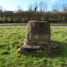
Asthall Barrow: an Anglo-Saxon burial mound 100m SSW of Barrow Farm, Anglo-Saxon burial mound in Asthall, England.

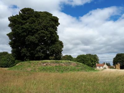
Asthall Barrow is an Anglo-Saxon burial mound located about 100 meters southwest of Barrow Farm. The mound rises around 2.4 meters high and spans roughly 17 meters across, with a dry stone wall built around its base to mark its boundary.

This mound was created in the 7th century as an important burial monument of Anglo-Saxon times. Excavations in 1923 and 1924 by George Bowles and Edward Thurlow Leeds uncovered not only Anglo-Saxon artifacts but also revealed older Roman-British pottery beneath the mound.

The mound served as a burial place for a wealthy person from early Anglo-Saxon times. The grave goods found here, including a bottle from Frankish lands and a silver bowl, reveal the high rank of the person buried within.

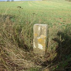
The site sits near the A40 road connecting Witney and Burford and remains accessible for visits. The ground is uneven with surrounding grassland, so wear appropriate footwear and take care when walking around.

Between 2009 and 2017, the monument underwent careful conservation to remove tree growth and repair rabbit damage. These restoration efforts have helped protect this Anglo-Saxon site for future visitors and researchers.

Location: Asthall

GPS coordinates: 51.78883,-1.58087

Latest update: December 12, 2025 12:06

Photos
Around this place
Asthall Manor
United Kingdom

Asthall Manor

1.3 km
Crocodiles of the World
United Kingdom

Crocodiles of the World

1.3 km
Church of St Mary, Swinbrook
United Kingdom

Church of St Mary, Swinbrook

2.3 km
Church of St Oswald
United Kingdom

Church of St Oswald

2.6 km
Church of St Britius
United Kingdom

Church of St Britius

2.7 km
Church of Saint Nicholas
United Kingdom

Church of Saint Nicholas

1.3 km
Church of the Holy Rood
United Kingdom

Church of the Holy Rood

2.9 km
The Old Swan Hotel
United Kingdom

The Old Swan Hotel

3.1 km
Minster Lovell Bridge
United Kingdom

Minster Lovell Bridge

3 km
The White Hart Public House
United Kingdom

The White Hart Public House

2.6 km
Swinbrook Manor House
United Kingdom

Swinbrook Manor House

2.3 km
Carterton War Memorial
United Kingdom

Carterton War Memorial

3.6 km
Brize Norton War Memorial
United Kingdom

Brize Norton War Memorial

2.7 km
The Old Post Office
United Kingdom

The Old Post Office

3.2 km
Group Of 6 Chest Tombs Approximately 7-10 Metres South Of Church Of St Mary
United Kingdom

Group Of 6 Chest Tombs Approximately 7-10 Metres South Of Church Of St Mary

2.3 km
The Bell House
United Kingdom

The Bell House

2.3 km
Minster Lovell War Memorial
United Kingdom

Minster Lovell War Memorial

2.6 km
Tullochs Cottage
United Kingdom

Tullochs Cottage

3.2 km
Carterton Library
United Kingdom

Carterton Library

3.5 km
Cross Base Approximately 10 Metres West Of The Old Swan Hotel
United Kingdom

Cross Base Approximately 10 Metres West Of The Old Swan Hotel

3.1 km
The Old Post House
United Kingdom

The Old Post House

3.4 km
Swinbrook Place
United Kingdom

Swinbrook Place

2.3 km
The Rosery
United Kingdom

The Rosery

3.1 km
Milestone, W of Barrow Plantation, on ridge above Astall; between A40 roundabout & turn to Brize
United Kingdom

Milestone, W of Barrow Plantation, on ridge above Astall; between A40 roundabout & turn to Brize

877 m
Milestone, Shilton Road; by No.26, N of garage
United Kingdom

Milestone, Shilton Road; by No.26, N of garage

2.6 km
Milestone, Station Road; opp. Church, in boundary wall of Stoneleigh House
United Kingdom

Milestone, Station Road; opp. Church, in boundary wall of Stoneleigh House

2.7 km
Milestone, Shilton Road; Barley Park
United Kingdom

Milestone, Shilton Road; Barley Park

3.2 km
Milestone, the old road down White Hill, just below from house
United Kingdom

Milestone, the old road down White Hill, just below from house

2.4 km
Show the full map
Reviews

Visited this place? Tap the stars to rate it and share your experience / photos with the community! Try now! You can cancel it anytime.

« Asthall Barrow: an Anglo-Saxon burial mound 100m SSW of Barrow Farm - Anglo-Saxon burial mound in Asthall, England » is provided by Around Us (aroundus.com). Images and texts are derived from Wikimedia project under a Creative Commons license. You are allowed to copy, distribute, and modify copies of this page, under the conditions set by the license, as long as this note is clearly visible.

Discover hidden gems everywhere you go!

From secret cafés to breathtaking viewpoints, skip the crowded tourist spots and find places that match your style. Our app makes it easy with voice search, smart filtering, route optimization, and insider tips from travelers worldwide. Download now for the complete mobile experience.

Around Us App Screenshot

A unique approach to discovering new places

Le Figaro

All the places worth exploring

France Info

A tailor-made excursion in just a few clicks

20 Minutes