Sully Hospital

Log in to your account

AroundUs is a community-driven map of interesting places, built by curious explorers like you. It grows with every review, story, and photo you share.
Connect to save your favorite spots, contribute locations, and create personalized routes.
Continue with Google
Continue with Apple
Continue with X
Continue with Facebook
Continue with email
By continuing, you accept our Terms and Conditions and our Privacy Policy
Create an account
Add to collection
Map
Suggest a change
Share

Sully Hospital, Grade II* listed former hospital in Sully and Lavernock, United Kingdom.

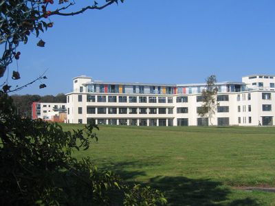
Sully Hospital is a former medical facility in Vale of Glamorgan, Wales, with a distinctive V-shaped structure oriented toward the Bristol Channel. The building features concrete frames supporting extensive glazing, while four separate sections containing staff quarters, administrative offices, specialist care areas, and patient wards are connected by interior hallways.

The building resulted from a design competition held in 1931 and was completed in 1936, opening under royal patronage. It originally functioned as a tuberculosis treatment facility designed to accommodate around 300 patients.

The architectural firm William Pite, Son and Fairweathers won the 1931 design competition, creating this example of Modernist sanatorium architecture.

Access to the former facility requires planning ahead as it sits in a remote location with limited transport connections to nearby communities. It is advisable to check in advance whether visits are permitted, as the building no longer operates as a public institution.

The south-facing wards feature rooms with fully opening windows on two sides, allowing maximum natural light and fresh sea air to reach patients. This was a deliberate design choice reflecting the belief that ventilation and sunlight aided respiratory recovery.

Location: Vale of Glamorgan

Inception: 1936

Elevation above the sea: 12 m

GPS coordinates: 51.40020,-3.23675

Latest update: December 14, 2025 16:42

Photos
Around this place
Barry Island Pleasure Park
United Kingdom

Barry Island Pleasure Park

2.9 km
Sully Island
United Kingdom

Sully Island

2.8 km
Barry Tourist Railway
United Kingdom

Barry Tourist Railway

2.8 km
Barry Memorial Hall
United Kingdom

Barry Memorial Hall

2.7 km
Barry Dock Offices
United Kingdom

Barry Dock Offices

1.8 km
Barry Council Office and Library
United Kingdom

Barry Council Office and Library

2.2 km
King's Square
United Kingdom

King's Square

2.2 km
Dovecote At Cadoxton Court, Mount Pleasant, Cadoxton
United Kingdom

Dovecote At Cadoxton Court, Mount Pleasant, Cadoxton

1.8 km
Barry Lighthouse
United Kingdom

Barry Lighthouse

1.8 km
St Cadoc's Church, Cadoxton
United Kingdom

St Cadoc's Church, Cadoxton

2.1 km
Church of St John the Baptist
United Kingdom

Church of St John the Baptist

1.3 km
St Mary's Church, Barry Dock
United Kingdom

St Mary's Church, Barry Dock

2 km
Sully Island
United Kingdom

Sully Island

2.9 km
Pedestrian Bridge
United Kingdom

Pedestrian Bridge

2.7 km
Pedestal And Statue Of David Davies, Subway Road (e Side), Barry Dock
United Kingdom

Pedestal And Statue Of David Davies, Subway Road (e Side), Barry Dock

1.8 km
4. Lampstandard Outside The Barry Docks Offices, Subway Road (E Side) , Barry Dock
United Kingdom

4. Lampstandard Outside The Barry Docks Offices, Subway Road (E Side) , Barry Dock

1.8 km
Hayes Farm Windmill
United Kingdom

Hayes Farm Windmill

374 m
5. Lampstandard Outside The Barry Docks Offices, Subway Road (E Side) , Barry Dock
United Kingdom

5. Lampstandard Outside The Barry Docks Offices, Subway Road (E Side) , Barry Dock

1.8 km
Seafront Wall
United Kingdom

Seafront Wall

2.8 km
3. Lampstandard Outside The Barry Docks Offices, Subway Road (E Side) , Barry Dock
United Kingdom

3. Lampstandard Outside The Barry Docks Offices, Subway Road (E Side) , Barry Dock

1.9 km
East Shelter
United Kingdom

East Shelter

2.6 km
Cenotaph (Including Area Walls and Steps), Gladstone Road (N Side)
United Kingdom

Cenotaph (Including Area Walls and Steps), Gladstone Road (N Side)

2.7 km
Sully and Lavernock Library
United Kingdom

Sully and Lavernock Library

1.7 km
Former Customs House and Mercantile Marine Office, Station Street (Sw Side) Barry
United Kingdom

Former Customs House and Mercantile Marine Office, Station Street (Sw Side) Barry

1.8 km
6. Lampstandard Outside The Barry Docks Offices, Subway Road (E Side) , Barry Dock
United Kingdom

6. Lampstandard Outside The Barry Docks Offices, Subway Road (E Side) , Barry Dock

1.8 km
Tabernacle Welsh Independent Chapel
United Kingdom

Tabernacle Welsh Independent Chapel

2.2 km
2. Lampstandard Outside The Barry Docks Offices, Subway Road (E Side) , Barry Dock
United Kingdom

2. Lampstandard Outside The Barry Docks Offices, Subway Road (E Side) , Barry Dock

1.9 km
Public Convenience
United Kingdom

Public Convenience

2.7 km
Show the full map
Reviews

Visited this place? Tap the stars to rate it and share your experience / photos with the community! Try now! You can cancel it anytime.

« Sully Hospital - Grade II* listed former hospital in Sully and Lavernock, United Kingdom » is provided by Around Us (aroundus.com). Images and texts are derived from Wikimedia project under a Creative Commons license. You are allowed to copy, distribute, and modify copies of this page, under the conditions set by the license, as long as this note is clearly visible.

Discover hidden gems everywhere you go!

From secret cafés to breathtaking viewpoints, skip the crowded tourist spots and find places that match your style. Our app makes it easy with voice search, smart filtering, route optimization, and insider tips from travelers worldwide. Download now for the complete mobile experience.

Around Us App Screenshot

A unique approach to discovering new places

Le Figaro

All the places worth exploring

France Info

A tailor-made excursion in just a few clicks

20 Minutes