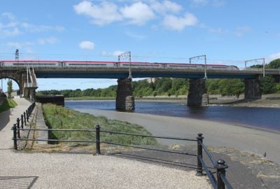
Carlisle Bridge, Railway bridge and Grade II listed building in Lancaster, England
Carlisle Bridge is a railway bridge in Lancaster that carries trains and pedestrians across the River Lune. It has three large stone arches that span the river and support the railway tracks running overhead.
Built between 1844 and 1846 by engineers Thomas Brassey, William Mackenzie, and John Stephenson, the bridge opened for railway service in 1847. Major strengthening work took place in 1962 and 1963 to improve its structural condition.
The structure represents a significant example of Victorian railway engineering, demonstrating the industrial capabilities and architectural standards of nineteenth-century Britain.
Pedestrians can use the bridge to cross the river, but expect wind, especially when trains pass by. It is less crowded during off-peak times when fewer trains are running.
Two piers sit directly in the river water, supporting the entire weight of the structure as you walk across. These underwater supports are visible from the pedestrian walkway and demonstrate the engineering required to build it.
Location: Lancaster
GPS coordinates: 54.05510,-2.80870
Latest update: December 14, 2025 11:43
Lancaster Priory
528 m
Lune Millennium Bridge
501 m
Custom House, Lancaster
271 m
Lancaster Priory
533 m
Church House
614 m
98, Church Street
609 m
100, Church Street
603 m
Wagon And Horses Public House
212 m
The Three Mariners Public House
579 m
Rawlinson Memorial, approximately 13 metres north of tower of Church of St Mary
501 m
Skerton Liberal Club
605 m
George And Dragon Public House
283 m
Three Warehouses, Now Part Of Number 26, Maritime Museum
223 m
21 And 22, St Georges Quay
295 m
Monument approximately 19 metres west of tower of Priory Church of St Mary
507 m
Victoria Corn Mill
359 m
23, St Georges Quay
289 m
Part of a Roman fort and its associated vicus and remains of a pre-Conquest monastery and a Benedictine priory on Castle Hill
460 m
Peel House
342 m
Quay Wall
365 m
Wery Wall
527 m
1-9, St Marys Parade
618 m
Church Steps
572 m
Ryelands House
472 m
Garden House Behind Number 2, Greycourt
517 m
Sundial approximately 15 metres south of tower of Priory Church of St Mary
529 m
Greycourt
591 m
Former Vicarage
527 mVisited this place? Tap the stars to rate it and share your experience / photos with the community! Try now! You can cancel it anytime.
Discover hidden gems everywhere you go!
From secret cafés to breathtaking viewpoints, skip the crowded tourist spots and find places that match your style. Our app makes it easy with voice search, smart filtering, route optimization, and insider tips from travelers worldwide. Download now for the complete mobile experience.
A unique approach to discovering new places❞
— Le Figaro
All the places worth exploring❞
— France Info
A tailor-made excursion in just a few clicks❞
— 20 Minutes