Enable Location

We need your location to show you interesting places around you

Discover nearby places

Find interesting locations and hidden gems around you

Precise directions

Get accurate directions and distances to places

Your location is never shared with other users. It's only used when you tap the location button.

Youngsbury

Log in to your account

Start exploring — it's free

Trusted by 63,294 travelers worldwide

Continue with Google
Continue with Apple
or

We will send you a code to connect

By continuing, you accept our Terms and Conditions and our Privacy Policy

Check your inbox

We've sent a pincode in your inbox. Please enter the code below.

Discussion Reviews 1 Photos
2.6k Popularity

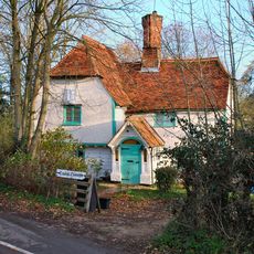
Youngsbury, English country house in High Cross, England

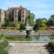
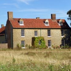
Youngsbury is a Georgian country house built with deep-red brick, containing two main floors and situated near Thundridge in Hertfordshire. An extension from the 19th century connects the main building to a period brewhouse that stands nearby.

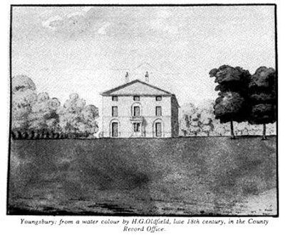
The house was built around 1745 as a three-story Palladian villa and underwent renovation in 1769. The top floor was removed in 1950, reducing it to the two-story structure that exists today.

The property takes its name from the family who shaped it over generations, and the landscape reflects their lasting connection to the land. Today, those who inhabit or work here use the gardens and parkland as an integral part of their daily rhythm.

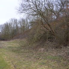
The property can be reached through the west drive from the A10 near Wadesmill, with a single-story Tudor-style lodge marking the entrance. Visitors should allow time to explore the large estate, as the grounds include multiple garden areas and woodland sections.

The kitchen garden contains an octagonal center planted with fruit trees, surrounded by multiple concentric walls built from red brick. This geometric layout dates to the 18th century and reveals careful garden design that visitors often miss.

The community of curious travelers

AroundUs brings together thousands of curated places, local tips, and hidden gems, enriched daily by 60,000 contributors worldwide.

Start exploring
Location
GPS coordinates
51.84284,-0.01427
Latest update
December 12, 2025 17:48
Around this place
Hanbury Manor
United Kingdom

Hanbury Manor

2.4 km
Fanhams Hall
United Kingdom

Fanhams Hall

2.3 km
Christ Church Ware
United Kingdom

Christ Church Ware

3.6 km
Downfield Pit
United Kingdom

Downfield Pit

2.4 km
Parish Church of St Mary
United Kingdom

Parish Church of St Mary

1.2 km
Church of St John the Evangelist
United Kingdom

Church of St John the Evangelist

934 m
Church of the Holy Trinity
United Kingdom

Church of the Holy Trinity

3.2 km
Church of St Katherine
United Kingdom

Church of St Katherine

3.6 km
The White Horse Inn
United Kingdom

The White Horse Inn

884 m
The Feathers Hotel
United Kingdom

The Feathers Hotel

976 m
Tonwell Water Tower (pronounced ('Tunnel')
United Kingdom

Tonwell Water Tower (pronounced ('Tunnel')

3.4 km
White Horse Public House
United Kingdom

White Horse Public House

3.5 km
The Rose And Crown Public House
United Kingdom

The Rose And Crown Public House

3.5 km
The Anchor Public House
United Kingdom

The Anchor Public House

1.1 km
The Robin Hood Public House
United Kingdom

The Robin Hood Public House

3.6 km
Crooked Chimneys
United Kingdom

Crooked Chimneys

3.1 km
Clarkson Monument On  High Cross Hill
United Kingdom

Clarkson Monument On High Cross Hill

884 m
The Cannon Tavern
United Kingdom

The Cannon Tavern

3.4 km
Milestone On South Corner Of Track To Athena Cottage
United Kingdom

Milestone On South Corner Of Track To Athena Cottage

954 m
The Chequers Public House
United Kingdom

The Chequers Public House

3.5 km
Remains Of Old Church Of St Mary And All Saints
United Kingdom

Remains Of Old Church Of St Mary And All Saints

558 m
Milestone (Next South East Corner Of Inglenook Cottage)
United Kingdom

Milestone (Next South East Corner Of Inglenook Cottage)

2.8 km
Milestone
United Kingdom

Milestone

1.3 km
Chelsing Farmhouse
United Kingdom

Chelsing Farmhouse

1.9 km
High Cross Puller Memorial C Of E Primary School (100 Metres To North Of Church)
United Kingdom

High Cross Puller Memorial C Of E Primary School (100 Metres To North Of Church)

1 km
Farmhouse At Fisher's Farm
United Kingdom

Farmhouse At Fisher's Farm

2.9 km
Milestone In Verge East Of Ware Fire Station (Not Included) At Tl 3558 1470
United Kingdom

Milestone In Verge East Of Ware Fire Station (Not Included) At Tl 3558 1470

3.5 km
Milestone, S of Tonwell beside footpath on track of old road E of A602
United Kingdom

Milestone, S of Tonwell beside footpath on track of old road E of A602

3.4 km
Show the full map
Reviews
Share your experience

No review yet

Discussions
Start a discussion...

No discussion yet

« Youngsbury - English country house in High Cross, England » is provided by Around Us (aroundus.com). Images and texts are derived from Wikimedia project under a Creative Commons license. You are allowed to copy, distribute, and modify copies of this page, under the conditions set by the license, as long as this note is clearly visible.

Discover hidden gems everywhere you go!

From secret cafés to breathtaking viewpoints, skip the crowded tourist spots and find places that match your style. Our app makes it easy with voice search, smart filtering, route optimization, and insider tips from travelers worldwide. Download now for the complete mobile experience.

Around Us App Screenshot

A unique approach to discovering new places

Le Figaro

All the places worth exploring

France Info

A tailor-made excursion in just a few clicks

20 Minutes

Around Us
Travel Guide & Maps
Download

Send to your phone

QR Code
1

Open the camera app on your mobile.

2

Point at the QR code with your camera. A notification will appear.

3

Tap the notification to open the link.