Chest opened
+${chestReward.xp} XP
Explorer
NOUVEAU ×${chestReward.collectible.quantity}
tapez pour fermer
Chest locked

Open chests in the app

Around Us is built for your phone — chests unlock when you walk, explore and capture nearby places.

Enable Location

We need your location to show you interesting places around you

Discover nearby places

Find interesting locations and hidden gems around you

Precise directions

Get accurate directions and distances to places

Your location is never shared with other users. It's only used when you tap the location button.

York Potash Ltd

Log in to your account

Start exploring — it's free

Trusted by 72,876 travelers worldwide

Continue with Google
Continue with Apple
or

We will send you a code to connect

By continuing, you accept our Terms and Conditions and our Privacy Policy

Check your inbox

We've sent a pincode in your inbox. Please enter the code below.

York Potash Ltd
Discussion Reviews 1 Photos
16.1k Popularity

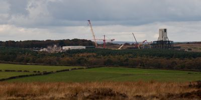
York Potash Ltd, Mineral mine in North Yorkshire, England

York Potash Ltd was a mining company registered in the United Kingdom that provided support services for mining and quarrying operations. The firm, established in December 2012, operated as a London-based business before its dissolution in May 2024.

York Potash Ltd was established in December 2012 as the mining sector in the UK continued to adapt to modern demands. The company's dissolution in 2024 reflects broader changes in the nation's industrial landscape and resource development strategies.

The company was based in London as an office-focused business and is no longer operational. Since it was dissolved in 2024, there are no visitor services or activities to experience at this location.

The community of curious travelers

AroundUs brings together thousands of curated places, local tips, and hidden gems, enriched daily by 60,000 contributors worldwide.

Start exploring
GPS coordinates
54.43188,-0.62504
Latest update
February 19, 2026 22:40
Around this place
Larpool Viaduct
United Kingdom

Larpool Viaduct

4.8 km
Old St Stephen's Church, Fylingdales
United Kingdom

Old St Stephen's Church, Fylingdales

5 km
Larpool Hall
United Kingdom

Larpool Hall

4.5 km
The Pigsty
United Kingdom

The Pigsty

4.4 km
Church of St John the Evangelist
United Kingdom

Church of St John the Evangelist

3.3 km
Church of All Saints
United Kingdom

Church of All Saints

4.5 km
Church of All Saints
United Kingdom

Church of All Saints

2.6 km
Church of St Hilda
United Kingdom

Church of St Hilda

3 km
Church of St Margaret
United Kingdom

Church of St Margaret

5.1 km
St Bartholomew's Church, Ruswarp
United Kingdom

St Bartholomew's Church, Ruswarp

4.3 km
Whitby Cemetery Chapels
United Kingdom

Whitby Cemetery Chapels

4.9 km
Fyling Hall
United Kingdom

Fyling Hall

4.4 km
Boundary Stone
United Kingdom

Boundary Stone

1.5 km
Line Of Boundary Stones Between Civil Parishes Of Sneaton And Eskdaleside Cum Ugglebarnby
United Kingdom

Line Of Boundary Stones Between Civil Parishes Of Sneaton And Eskdaleside Cum Ugglebarnby

3.8 km
Aislaby War Memorial
United Kingdom

Aislaby War Memorial

5.2 km
John Cross
United Kingdom

John Cross

2.3 km
Whitby Cemetery Lodge
United Kingdom

Whitby Cemetery Lodge

4.9 km
Ruswarp Mill
United Kingdom

Ruswarp Mill

4.2 km
Ruswarp railway bridge
United Kingdom

Ruswarp railway bridge

4.2 km
Hawsker Cross wayside cross, 100m east of Hawsker Hall Farm
United Kingdom

Hawsker Cross wayside cross, 100m east of Hawsker Hall Farm

4 km
Robin Hood And Little John Stones
United Kingdom

Robin Hood And Little John Stones

5.2 km
Milepost Approximately 10 Metres West Of Number 137
United Kingdom

Milepost Approximately 10 Metres West Of Number 137

3.5 km
'Breckon Howe' round barrow, Sleights Moor
United Kingdom

'Breckon Howe' round barrow, Sleights Moor

4.2 km
Breckon Howe Boundary Stone Between Parishes Od Eskdaleside Cum Ugglebarnsby And Goathland
United Kingdom

Breckon Howe Boundary Stone Between Parishes Od Eskdaleside Cum Ugglebarnsby And Goathland

4.2 km
York Cross wayside cross, 700m north east of Foster Howes on Sneaton High Moor
United Kingdom

York Cross wayside cross, 700m north east of Foster Howes on Sneaton High Moor

3.7 km
Wayside cross called Postgate Cross on Graystone Hills 700m NNE of Sneaton Corner
United Kingdom

Wayside cross called Postgate Cross on Graystone Hills 700m NNE of Sneaton Corner

2.6 km
Ann's Cross
United Kingdom

Ann's Cross

5 km
Boundary Stone
United Kingdom

Boundary Stone

4.1 km
Show the full map
Reviews
Share your experience

No review yet

Discussions
Start a discussion...

No discussion yet

« York Potash Ltd - Mineral mine in North Yorkshire, England » is provided by Around Us (aroundus.com). Images and texts are derived from Wikimedia project under a Creative Commons license. You are allowed to copy, distribute, and modify copies of this page, under the conditions set by the license, as long as this note is clearly visible.

Discover hidden gems everywhere you go!

From secret cafés to breathtaking viewpoints, skip the crowded tourist spots and find places that match your style. Our app makes it easy with voice search, smart filtering, route optimization, and insider tips from travelers worldwide. Download now for the complete mobile experience.

Around Us App Screenshot

A unique approach to discovering new places

Le Figaro

All the places worth exploring

France Info

A tailor-made excursion in just a few clicks

20 Minutes

Around Us
Travel Guide & Maps
Download

Send to your phone

QR Code
1

Open the camera app on your mobile.

2

Point at the QR code with your camera. A notification will appear.

3

Tap the notification to open the link.