Huggin's Hall, building in Cranbrook, Tunbridge Wells, Kent, UK
Location: Cranbrook & Sissinghurst
GPS coordinates: 51.09097,0.51009
Latest update: November 21, 2025 14:45

Hill Cottages
829 m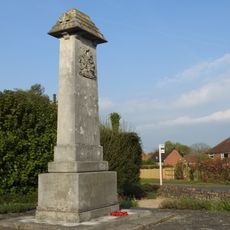
Cranbrook War Memorial
994 m
Goddards Green Farmhouse
923 m
Barn 20 Yards South East Of Charity Farmhouse
1.3 km
Barn At Goddard's Green Farm
995 m
Hall Wood Farmhouse
1.2 km
Charity Farmhouse
1.3 km
Bull Farmhouse
738 m
Oast And Granary 20 Yards West Of Charity Farmhouse
1.3 km
Little Charity
1.3 km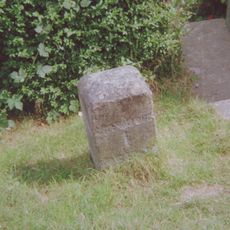
Milestone, Hartley village, by "Pleasant View"(was Hartley House)
456 m
The Cottage
953 m
Corn Hall Farmhouse
1.4 km
May Cottage
1.5 km
Angley Farmhouse
620 m
Hartley House
805 m
Turnden
733 m
Hartley House
384 m
Hartley Gate Farmhouse
584 m
Turk's Place
1.1 km
Cranehurst
1.4 km
Chilworth
1.4 km
Thyme Cottage
1.5 km
Barn 50 Yards North Of Bull Farmhouse
711 m
Angley Farm Cottages
664 m
Hartley Farmhouse
666 m
Briar Cottage Myrtles
1.4 km
Beemans
1.4 kmReviews
Visited this place? Tap the stars to rate it and share your experience / photos with the community! Try now! You can cancel it anytime.
Discover hidden gems everywhere you go!
From secret cafés to breathtaking viewpoints, skip the crowded tourist spots and find places that match your style. Our app makes it easy with voice search, smart filtering, route optimization, and insider tips from travelers worldwide. Download now for the complete mobile experience.

A unique approach to discovering new places❞
— Le Figaro
All the places worth exploring❞
— France Info
A tailor-made excursion in just a few clicks❞
— 20 Minutes