Brown County Courthouse

Log in to your account

AroundUs is a community-driven map of interesting places, built by curious explorers like you. It grows with every review, story, and photo you share.
Connect to save your favorite spots, contribute locations, and create personalized routes.
Continue with Google
Continue with Apple
Continue with X
Continue with Facebook
Continue with email
By continuing, you accept our Terms and Conditions and our Privacy Policy
Create an account
Add to collection
Map
Suggest a change
Share

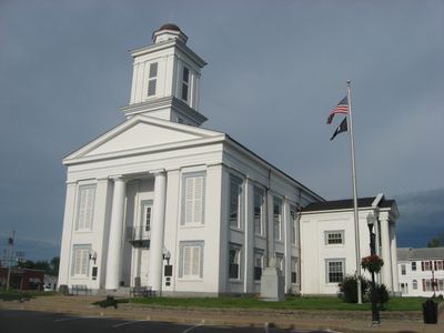
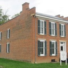
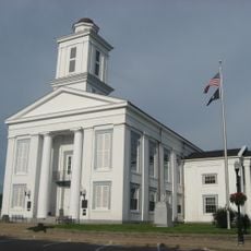
Brown County Courthouse, County courthouse in Georgetown, United States.

The Brown County Courthouse is a county courthouse in Georgetown featuring Greek Revival style with white painted brick walls, blue trim details, and Doric columns supporting the gabled entrance. The building occupies a prominent square bounded by Grant Street, Apple Street, Cherry Street, and Main Street.

The building was constructed in 1851 following designs by architect Hubbard Baker to replace an earlier structure after Brown County relocated its administrative seat from Ripley to Georgetown. This move marked an important shift in Georgetown's development as the region's administrative center.

The courthouse serves as a focal point in Georgetown's historic district and shows how the town organized its public life around civic institutions. Visitors can observe the building's role as a gathering place for the community's most important legal and administrative functions.

The courthouse sits at the heart of Georgetown's downtown area and is easy to reach on foot from surrounding streets. Visitors can view the exterior architecture from the adjacent square and appreciate the building from multiple angles.

During the Civil War in 1863, Morgan's Raiders stopped at the courthouse and many horses and valuables disappeared during their brief occupation. This episode is often overlooked by visitors but remains an important part of the building's story.

Location: Georgetown

Architectural style: Greek Revival architecture

Part of: Georgetown Historic District

GPS coordinates: 38.86556,-83.90389

Latest update: December 14, 2025 14:22

Photos
Around this place
East Fork State Park
United States of America

East Fork State Park

25 km
John Rankin House
United States of America

John Rankin House

13.8 km
Grant Boyhood Home
United States of America

Grant Boyhood Home

157 m
William H. Harsha Bridge
United States of America

William H. Harsha Bridge

22.8 km
Rosemary Clooney Museum
United States of America

Rosemary Clooney Museum

13.5 km
John P. Parker House
United States of America

John P. Parker House

13.7 km
Bullskin Creek Site
United States of America

Bullskin Creek Site

18.8 km
Confederate Monument in Augusta
United States of America

Confederate Monument in Augusta

14.2 km
Lee's Creek Covered Bridge
United States of America

Lee's Creek Covered Bridge

13.1 km
Walcott Covered Bridge
United States of America

Walcott Covered Bridge

22.5 km
William Winter Stone House
United States of America

William Winter Stone House

16.6 km
North Pole Road Covered Bridge
United States of America

North Pole Road Covered Bridge

17.2 km
Bracken Baptist Church
United States of America

Bracken Baptist Church

17.8 km
Pogue House
United States of America

Pogue House

25.1 km
Pisgah Christian Church
United States of America

Pisgah Christian Church

9.5 km
Aberdeen Mound
United States of America

Aberdeen Mound

25.2 km
Eagle Creek Covered Bridge
United States of America

Eagle Creek Covered Bridge

19.6 km
Georgetown Historic District
United States of America

Georgetown Historic District

0 m
Brothers-O'Neil House
United States of America

Brothers-O'Neil House

13.3 km
Bailey-Thompson House
United States of America

Bailey-Thompson House

193 m
James Weldon House
United States of America

James Weldon House

13.2 km
Wells-Keith House
United States of America

Wells-Keith House

13.3 km
Sutton House
United States of America

Sutton House

18.7 km
Ben Moran House
United States of America

Ben Moran House

22.6 km
Bradford School House
United States of America

Bradford School House

22.6 km
US Grant Boyhood Home and Schoolhouse
United States of America

US Grant Boyhood Home and Schoolhouse

183 m
William H. Harsha Lake
United States of America

William H. Harsha Lake

24.6 km
New Hope Covered Bridge
United States of America

New Hope Covered Bridge

10.5 km
Show the full map
Reviews

Visited this place? Tap the stars to rate it and share your experience / photos with the community! Try now! You can cancel it anytime.

« Brown County Courthouse - County courthouse in Georgetown, United States » is provided by Around Us (aroundus.com). Images and texts are derived from Wikimedia project under a Creative Commons license. You are allowed to copy, distribute, and modify copies of this page, under the conditions set by the license, as long as this note is clearly visible.

Discover hidden gems everywhere you go!

From secret cafés to breathtaking viewpoints, skip the crowded tourist spots and find places that match your style. Our app makes it easy with voice search, smart filtering, route optimization, and insider tips from travelers worldwide. Download now for the complete mobile experience.

Around Us App Screenshot

A unique approach to discovering new places

Le Figaro

All the places worth exploring

France Info

A tailor-made excursion in just a few clicks

20 Minutes