Grant Wood's "Fall Plowing" Rural Historic Landscape District

Log in to your account

AroundUs is a community-driven map of interesting places, built by curious explorers like you. It grows with every review, story, and photo you share.
Connect to save your favorite spots, contribute locations, and create personalized routes.
Continue with Google
Continue with Apple
Continue with X
Continue with Facebook
Continue with email
By continuing, you accept our Terms and Conditions and our Privacy Policy
Create an account

Grant Wood's "Fall Plowing" Rural Historic Landscape District

Add to collection
Map
Suggest a change
Share

Grant Wood's "Fall Plowing" Rural Historic Landscape District, Historic district in Viola, Iowa, United States

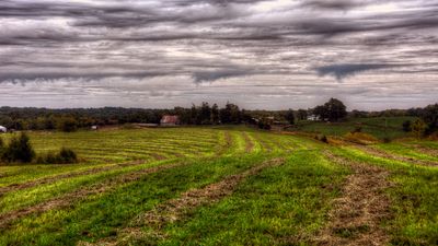
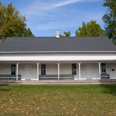
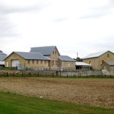
Grant Wood's Fall Plowing Rural Historic Landscape District is an agricultural area north of Viola featuring traditional farm buildings set into gently rolling terrain. The district contains several historic structures and sites that reflect early 20th-century farming practices in the region.

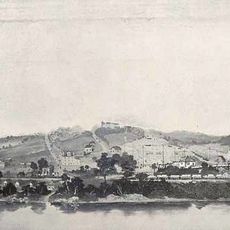
The district earned its National Register listing in 2003 for preserving the exact location that inspired Grant Wood's 1931 painting Fall Plowing. The landscape documents how Midwest farmland became a source of artistic inspiration during that period.

The landscape reflects how rural communities inspired artists in the Midwest during the early 20th century. Visitors can see the rolling terrain and field patterns that caught the eye of painters working in the region.

The district lies north of Viola near Matsell Lane and Stone City Road and can be explored on foot or by vehicle. The open landscape offers clear views of the historic buildings and fields that define the area.

Two of the original barns in the district appear in Grant Wood's preliminary sketches for the painting but were deliberately excluded from the final version of Fall Plowing. These differences reveal how Wood carefully refined his composition before completing the work.

Location: Iowa

GPS coordinates: 42.11528,-91.38889

Latest update: December 14, 2025 18:45

Photos
Around this place
Anamosa State Penitentiary
United States of America

Anamosa State Penitentiary

8.1 km
Wapsipinicon State Park
United States of America

Wapsipinicon State Park

8.8 km
John A. Green Estate
United States of America

John A. Green Estate

3.1 km
St. Joseph's Roman Catholic Church
United States of America

St. Joseph's Roman Catholic Church

2.8 km
Jones County Courthouse
United States of America

Jones County Courthouse

8.2 km
Pucker Street Historic District
United States of America

Pucker Street Historic District

19.1 km
Whittier Friends Meeting House
United States of America

Whittier Friends Meeting House

6.7 km
Terrace Park Historic District
United States of America

Terrace Park Historic District

19.3 km
Hale Bridge
United States of America

Hale Bridge

9.8 km
First Presbyterian Church of Marion, Iowa
United States of America

First Presbyterian Church of Marion, Iowa

19.4 km
Matsell Bridge
United States of America

Matsell Bridge

1.8 km
Col. William T. and Elizabeth C. Shaw House
United States of America

Col. William T. and Elizabeth C. Shaw House

9.7 km
Antioch School
United States of America

Antioch School

14.8 km
Anamosa Main Street Historic District
United States of America

Anamosa Main Street Historic District

8.6 km
Farm No. 1, Iowa Men's Reformatory
United States of America

Farm No. 1, Iowa Men's Reformatory

7.2 km
Marion Carnegie Public Library
United States of America

Marion Carnegie Public Library

19.4 km
Central City Commercial Historic District
United States of America

Central City Commercial Historic District

14.9 km
Lower Road Bridge
United States of America

Lower Road Bridge

6.9 km
Edmund and Mary Ann Walworth Booth House
United States of America

Edmund and Mary Ann Walworth Booth House

8.6 km
Marion Commercial Historic District
United States of America

Marion Commercial Historic District

19.6 km
Beach School
United States of America

Beach School

15.6 km
Rick's Brewery
United States of America

Rick's Brewery

7.3 km
James W. and Ida G. Bowman House
United States of America

James W. and Ida G. Bowman House

19.3 km
Glenn O. and Lucy O. Pyle House
United States of America

Glenn O. and Lucy O. Pyle House

19.2 km
Joseph P. Mentzer House
United States of America

Joseph P. Mentzer House

19.1 km
Samuel M. Lane House
United States of America

Samuel M. Lane House

19 km
Granger House
United States of America

Granger House

19.5 km
Anamosa Bridge
United States of America

Anamosa Bridge

8.2 km
Show the full map
Reviews

Visited this place? Tap the stars to rate it and share your experience / photos with the community! Try now! You can cancel it anytime.

« Grant Wood's "Fall Plowing" Rural Historic Landscape District - Historic district in Viola, Iowa, United States » is provided by Around Us (aroundus.com). Images and texts are derived from Wikimedia project under a Creative Commons license. You are allowed to copy, distribute, and modify copies of this page, under the conditions set by the license, as long as this note is clearly visible.

Discover hidden gems everywhere you go!

From secret cafés to breathtaking viewpoints, skip the crowded tourist spots and find places that match your style. Our app makes it easy with voice search, smart filtering, route optimization, and insider tips from travelers worldwide. Download now for the complete mobile experience.

Around Us App Screenshot

A unique approach to discovering new places

Le Figaro

All the places worth exploring

France Info

A tailor-made excursion in just a few clicks

20 Minutes