Mercer's Mill Covered Bridge

Log in to your account

AroundUs is a community-driven map of interesting places, built by curious explorers like you. It grows with every review, story, and photo you share.
Connect to save your favorite spots, contribute locations, and create personalized routes.
Continue with Google
Continue with Apple
Continue with X
Continue with Facebook
Continue with email
By continuing, you accept our Terms and Conditions and our Privacy Policy
Create an account
Add to collection
Map
Suggest a change
Share

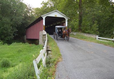
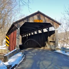
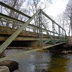
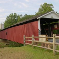
Mercer's Mill Covered Bridge, Covered bridge across East Branch Octoraro Creek in Sadsbury Township, Pennsylvania.

Mercer's Mill Covered Bridge is a wooden structure that crosses the East Branch Octoraro Creek. The red-painted span stretches about 80 feet (24 m) in length and measures approximately 15 feet (5 m) in width, featuring double Burr arch trusses reinforced with steel hanger rods.

B.J. Carter built this bridge in 1880 to connect Lancaster and Chester Counties. It was constructed during the peak era of covered bridge building across the United States.

This bridge served as a vital crossing point for farmers and residents in the surrounding rural communities for generations. It remains a landmark that reflects how transportation infrastructure once shaped daily life in agricultural areas.

The bridge sits about 1 kilometer (0.5 miles) south of Christiana and is accessible via Bailey Crossroads Road. You can reach it easily from Creek Road near Pennsylvania Route 372.

The structure has just one window on its side, setting it apart from other covered bridges in the area. This distinctive feature makes it a popular subject for visitors' photographs.

Location: Sadsbury Township

Location: West Fallowfield Township

GPS coordinates: 39.93150,-75.98150

Latest update: December 14, 2025 14:25

Photos
Around this place
John Wentz House
United States of America

John Wentz House

12.7 km
White Chimneys
United States of America

White Chimneys

8.7 km
Andrews Bridge Historic District
United States of America

Andrews Bridge Historic District

7.1 km
Robert Young House
United States of America

Robert Young House

13.9 km
Hopewell Farm
United States of America

Hopewell Farm

10.4 km
Lukens Pierce House
United States of America

Lukens Pierce House

11.5 km
Asa Walton House
United States of America

Asa Walton House

11.2 km
John Douglass House
United States of America

John Douglass House

7.7 km
Thomas Scott House
United States of America

Thomas Scott House

11.6 km
Parkesburg National Bank
United States of America

Parkesburg National Bank

5.9 km
Moses Ross House
United States of America

Moses Ross House

10.1 km
Joseph and Esther Phillips Plantation
United States of America

Joseph and Esther Phillips Plantation

860 m
Speakman No. 1
United States of America

Speakman No. 1

13.5 km
House at Springdell
United States of America

House at Springdell

12.8 km
Philip Dougherty House
United States of America

Philip Dougherty House

9.8 km
Cyrus Hoopes House and Barn
United States of America

Cyrus Hoopes House and Barn

12.9 km
Robert Wilson House
United States of America

Robert Wilson House

12.1 km
Bridge in West Fallowfield Township
United States of America

Bridge in West Fallowfield Township

5.5 km
David Scott House
United States of America

David Scott House

10.7 km
John Bailey Farm
United States of America

John Bailey Farm

12 km
Isaac Pawling House
United States of America

Isaac Pawling House

11.7 km
Harry DeHaven House
United States of America

Harry DeHaven House

11.6 km
Edward Dougherty House
United States of America

Edward Dougherty House

10.8 km
John Ferron House
United States of America

John Ferron House

11.7 km
Glen Rose Historic District
United States of America

Glen Rose Historic District

10.5 km
Mansel Passmore House
United States of America

Mansel Passmore House

11.1 km
Rough & Tumble Engineers Msm
United States of America

Rough & Tumble Engineers Msm

9.6 km
Jackson's Sawmill Covered Bridge
United States of America

Jackson's Sawmill Covered Bridge

9.2 km
Show the full map
Reviews

Visited this place? Tap the stars to rate it and share your experience / photos with the community! Try now! You can cancel it anytime.

« Mercer's Mill Covered Bridge - Covered bridge across East Branch Octoraro Creek in Sadsbury Township, Pennsylvania » is provided by Around Us (aroundus.com). Images and texts are derived from Wikimedia project under a Creative Commons license. You are allowed to copy, distribute, and modify copies of this page, under the conditions set by the license, as long as this note is clearly visible.

Discover hidden gems everywhere you go!

From secret cafés to breathtaking viewpoints, skip the crowded tourist spots and find places that match your style. Our app makes it easy with voice search, smart filtering, route optimization, and insider tips from travelers worldwide. Download now for the complete mobile experience.

Around Us App Screenshot

A unique approach to discovering new places

Le Figaro

All the places worth exploring

France Info

A tailor-made excursion in just a few clicks

20 Minutes