Northern boundary of Massachusetts

Log in to your account

AroundUs is a community-driven map of interesting places, built by curious explorers like you. It grows with every review, story, and photo you share.
Connect to save your favorite spots, contribute locations, and create personalized routes.
Continue with Google
Continue with Apple
Continue with X
Continue with Facebook
Continue with email
By continuing, you accept our Terms and Conditions and our Privacy Policy
Create an account

Northern boundary of Massachusetts

Add to collection
Map
Suggest a change
Share

Northern boundary of Massachusetts, State boundary marker in Vermont, United States

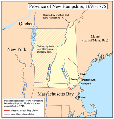
The northern boundary of Massachusetts is a series of straight line segments running from the northwestern corner eastward. Granite markers positioned along this line precisely indicate where the state of Massachusetts meets neighboring territories.

King George II established the current northern boundary in 1740, positioning it three miles from the Merrimack River. This decision shaped the territorial divisions that define the states today.

The boundary reflects how different states developed their own ways of organizing land and government. Visitors walking along the marker line notice how the landscape and local character shift between the two sides.

Granite markers placed along the boundary line help visitors locate the exact position where states meet. Following these markers from west to east provides a clear path for exploring the division.

A copper bolt marks the exact point where the borders of Vermont, Massachusetts, and New Hampshire meet. This three-state junction is a rare feature that draws those interested in boundary geography.

Location: Vermont

GPS coordinates: 42.74580,-73.26500

Latest update: December 10, 2025 16:01

Photos
Around this place
Clark Art Institute
United States of America

Clark Art Institute

6 km
Massachusetts Museum of Contemporary Art
United States of America

Massachusetts Museum of Contemporary Art

13.1 km
Field Farm
United States of America

Field Farm

8.9 km
Mount Fitch
United States of America

Mount Fitch

13.2 km
Wells House
United States of America

Wells House

11.9 km
Weston Field
United States of America

Weston Field

6.6 km
Mooar-Wright House
United States of America

Mooar-Wright House

3.1 km
Hopkins Observatory
United States of America

Hopkins Observatory

6.4 km
1753 House
United States of America

1753 House

5.7 km
Congregation Beth Israel
United States of America

Congregation Beth Israel

9.5 km
Hillside Cemetery
United States of America

Hillside Cemetery

12.6 km
Five Corners Historic District
United States of America

Five Corners Historic District

9.8 km
Hathaway Tenement
United States of America

Hathaway Tenement

12.8 km
Dickinson Hill Fire Tower
United States of America

Dickinson Hill Fire Tower

13.3 km
Boston Finishing Works
United States of America

Boston Finishing Works

6.9 km
Williamstown Rail Yard and Station Historic District
United States of America

Williamstown Rail Yard and Station Historic District

6.8 km
Armstrong House
United States of America

Armstrong House

13.1 km
Crowley House
United States of America

Crowley House

12.3 km
Eber Sherman Farm
United States of America

Eber Sherman Farm

9.3 km
United States Post Office–Williamstown Main
United States of America

United States Post Office–Williamstown Main

6.4 km
Mill Village Historic District
United States of America

Mill Village Historic District

6.9 km
William B. Sherman Farm
United States of America

William B. Sherman Farm

9 km
Col. Benjamin Simond House
United States of America

Col. Benjamin Simond House

5.2 km
Sykes House
United States of America

Sykes House

12 km
Williams College Museum of Art
United States of America

Williams College Museum of Art

6.4 km
Mount Raimer
United States of America

Mount Raimer

3.6 km
'62 Center for Theatre and Dance
United States of America

'62 Center for Theatre and Dance

5.9 km
Norad Mill
United States of America

Norad Mill

11.6 km
Show the full map
Reviews

Visited this place? Tap the stars to rate it and share your experience / photos with the community! Try now! You can cancel it anytime.

« Northern boundary of Massachusetts - State boundary marker in Vermont, United States » is provided by Around Us (aroundus.com). Images and texts are derived from Wikimedia project under a Creative Commons license. You are allowed to copy, distribute, and modify copies of this page, under the conditions set by the license, as long as this note is clearly visible.

Discover hidden gems everywhere you go!

From secret cafés to breathtaking viewpoints, skip the crowded tourist spots and find places that match your style. Our app makes it easy with voice search, smart filtering, route optimization, and insider tips from travelers worldwide. Download now for the complete mobile experience.

Around Us App Screenshot

A unique approach to discovering new places

Le Figaro

All the places worth exploring

France Info

A tailor-made excursion in just a few clicks

20 Minutes