Potanipo Hill, Mountain summit in Brookline, New Hampshire, United States.
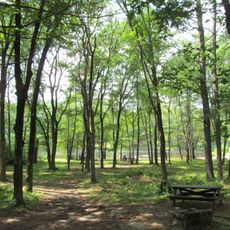
Potanipo Hill is a forested mountain in Brookline with rocky pathways and multiple marked trails of varying difficulty. The property has several entry points through which hikers can explore the terrain.
The mountain's eastern slope hosted one of New England's first ski areas, called Brookline Ski Area, until its closure in 1984. Since then the land has been converted to hiking and art programming.
The Andres Institute of Art uses the mountain as an open-air gallery, displaying works by international artists along the hiking paths. Visitors encounter sculptures positioned among trees and rocks throughout the landscape.
Access is available from multiple locations, including the Southway Trail Loop which offers options for various fitness levels. Visitors should wear sturdy footwear since the paths are rocky and can be challenging in places.
The mountain unusually combines outdoor recreation with an open-air art exhibition where sculptures share the natural space. This hybrid approach makes it a rare place where hiking and art appreciation overlap.
Location: New Hampshire
GPS coordinates: 42.72731,-71.67285
Latest update: December 14, 2025 16:42
Pearl Hill State Park
11.4 km
Andres Institute of Art
295 m
Barrett House
15.3 km
Silver Lake State Park
7.6 km
Andy's Summer Playhouse
14.3 km
Milford Suspension Bridge
12.4 km
Wilton Town Hall Theatre
14 km
New Ipswich Town Hall
15 km
Reed Homestead
8.3 km
Groton Leatherboard Company
14.4 km
William Peabody House
13 km
Hollis Village Historic District
7.3 km
Lunenburg Historic District
15.3 km
McClure-Hilton House
15 km
The Meetinghouse
7 km
Wilton Public and Gregg Free Library
14.2 km
New Ipswich Center Village Historic District
15.2 km
Marion Nichols Summer Home
6 km
Milford Town House and Library Annex
12.2 km
District 7 School
14.7 km
Pepperell Center Historic District
9.1 km
Ashby Free Public Library
13.2 km
Mine Falls Park
14 km
Pepperell Covered Bridge
10.2 km
Livermore Bridge
14.3 km
Great Trestle
12.6 km
MBRX Souhegan River Bridge
14 km
Runnels Bridge
10.3 kmVisited this place? Tap the stars to rate it and share your experience / photos with the community! Try now! You can cancel it anytime.
Discover hidden gems everywhere you go!
From secret cafés to breathtaking viewpoints, skip the crowded tourist spots and find places that match your style. Our app makes it easy with voice search, smart filtering, route optimization, and insider tips from travelers worldwide. Download now for the complete mobile experience.
A unique approach to discovering new places❞
— Le Figaro
All the places worth exploring❞
— France Info
A tailor-made excursion in just a few clicks❞
— 20 Minutes