Enable Location

We need your location to show you interesting places around you

Discover nearby places

Find interesting locations and hidden gems around you

Precise directions

Get accurate directions and distances to places

Your location is never shared with other users. It's only used when you tap the location button.

Log in to your account

Start exploring — it's free

Trusted by 62,522 travelers worldwide

Continue with Google
Continue with Apple
or

We will send you a code to connect

By continuing, you accept our Terms and Conditions and our Privacy Policy

Check your inbox

We've sent a pincode in your inbox. Please enter the code below.

Woodcliff Lake Reservoir

Woodcliff Lake Reservoir, reservoir in New Jersey, United States

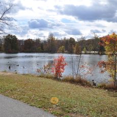
Woodcliff Lake Reservoir is a human-made lake in Bergen County, New Jersey, created by damming Pascack Brook and fed by Bear Brook, stretching across the towns of Woodcliff Lake, Hillsdale, and Park Ridge. The water surface sits at about 98 feet above sea level and can hold over 870 million gallons, serving as a major water supply for nearby communities.

The reservoir was built around 1903 by damming Pascack Brook to create a water supply for the growing communities in the region. The creation of this water source was significant enough that the nearby town changed its name from Woodcliff to Woodcliff Lake, anchoring the new identity of the area.

The reservoir became so important to the local area that the nearby town renamed itself to match its name, reflecting how central this water source is to the community. People gather here to fish, watch waterfowl, or simply find quiet moments in a place where nature and daily life intersect.

Two main roads cross the reservoir: Church Road over the dam and the wider Woodcliff Avenue over a causeway, with a nearby train station offering access via the New Jersey Transit Pascack Valley Line. To fish here, you need a valid New Jersey fishing license and an annual Watershed Permit to help protect the water quality used for drinking.

When water levels drop significantly, an old stone bridge becomes visible just south of the main road crossing, offering a glimpse of the landscape before the reservoir was created. This submerged structure serves as a quiet reminder of how the land was transformed to meet the area's water needs.

The community of curious travelers

AroundUs brings together thousands of curated places, local tips, and hidden gems, enriched daily by 60,000 contributors worldwide.

Start exploring
Location
GPS coordinates
41.01910,-74.04340
Latest update
February 9, 2026 08:23
Around this place
Achenbach House
United States of America

Achenbach House

3.8 km
Seven Chimneys
United States of America

Seven Chimneys

4.5 km
Wortendyke Barn
United States of America

Wortendyke Barn

1.3 km
Joe Jefferson Clubhouse
United States of America

Joe Jefferson Clubhouse

4.5 km
Pascack Brook County Park
United States of America

Pascack Brook County Park

4.3 km
Edward Salyer House
United States of America

Edward Salyer House

4.4 km
Ackerman House
United States of America

Ackerman House

3.7 km
Ackerman-Dater House
United States of America

Ackerman-Dater House

5 km
John G. Ackerson House
United States of America

John G. Ackerson House

1 km
Andries Thomas Van Buskirk House
United States of America

Andries Thomas Van Buskirk House

4.4 km
Ackerman-Smith House
United States of America

Ackerman-Smith House

3.8 km
Evangelical Lutheran Church of Saddle River and Ramapough Building
United States of America

Evangelical Lutheran Church of Saddle River and Ramapough Building

4.7 km
Alonzo Foringer House and Studio
United States of America

Alonzo Foringer House and Studio

4.5 km
Gerrit Haring House
United States of America

Gerrit Haring House

4.8 km
John Banta House
United States of America

John Banta House

1.6 km
Westervelt-Lydecker House
United States of America

Westervelt-Lydecker House

2.2 km
Frederick Wortendyke House
United States of America

Frederick Wortendyke House

975 m
Terhune-Ranlett House
United States of America

Terhune-Ranlett House

4.6 km
Frederick Wortendyke House
United States of America

Frederick Wortendyke House

296 m
J. J. Carlock House
United States of America

J. J. Carlock House

4.1 km
William Holdrum House
United States of America

William Holdrum House

2.8 km
Stillwell-Preston House
United States of America

Stillwell-Preston House

4.5 km
Peter P. Post House
United States of America

Peter P. Post House

433 m
Garret K. Osborn House and Barn
United States of America

Garret K. Osborn House and Barn

4.8 km
Forshee-Van Orden House
United States of America

Forshee-Van Orden House

4.6 km
Peter D. Perry House
United States of America

Peter D. Perry House

1.2 km
Blauvelt-Demarest House
United States of America

Blauvelt-Demarest House

1.4 km
Holdrum-Van Houten House
United States of America

Holdrum-Van Houten House

3.8 km
Show the full map
« Woodcliff Lake Reservoir - reservoir in New Jersey, United States » is provided by Around Us (aroundus.com). Images and texts are derived from Wikimedia project under a Creative Commons license. You are allowed to copy, distribute, and modify copies of this page, under the conditions set by the license, as long as this note is clearly visible.

Discover hidden gems everywhere you go!

From secret cafés to breathtaking viewpoints, skip the crowded tourist spots and find places that match your style. Our app makes it easy with voice search, smart filtering, route optimization, and insider tips from travelers worldwide. Download now for the complete mobile experience.

Around Us App Screenshot

A unique approach to discovering new places

Le Figaro

All the places worth exploring

France Info

A tailor-made excursion in just a few clicks

20 Minutes

Around Us
Travel Guide & Maps
Download

Send to your phone

QR Code
1

Open the camera app on your mobile.

2

Point at the QR code with your camera. A notification will appear.

3

Tap the notification to open the link.