Enable Location

We need your location to show you interesting places around you

Discover nearby places

Find interesting locations and hidden gems around you

Precise directions

Get accurate directions and distances to places

Your location is never shared with other users. It's only used when you tap the location button.

Weston Reservoir

Log in to your account

Start exploring — it's free

Trusted by 62,565 travelers worldwide

Continue with Google
Continue with Apple
or

We will send you a code to connect

By continuing, you accept our Terms and Conditions and our Privacy Policy

Check your inbox

We've sent a pincode in your inbox. Please enter the code below.

Weston Reservoir

Weston Reservoir, body of water

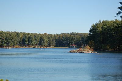
Weston Reservoir is a body of water in Massachusetts that functions as a backup water supply for the region. It covers about 3.5 square miles and reaches depths over 100 feet (30 meters), with underground tanks ready to distribute water during emergencies.

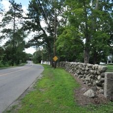
The reservoir is part of the Weston Aqueduct Linear Historic District, listed on the National Register of Historic Places since 1990. It was built to store water for the community and remains an essential part of the region's water security system.

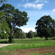
The name reflects its connection to the nearby town of Weston. The reservoir serves as a gathering spot where locals come to walk dogs and enjoy peaceful time outdoors, showing how central this space is to the community's everyday life.

The trail is about two miles long and starts near a small parking area on Ash Street. The surface can be slippery depending on the season, especially in winter with snow and ice, so special footwear like Yaktrax is helpful for traction.

The reservoir is framed by tall pine trees that reflect in the water and create a wooded feeling throughout the area. A volunteer group called Friends of Weston Reservoir has maintained the trails and provided free dog waste bags for over 15 years to keep the paths clean.

The community of curious travelers

AroundUs brings together thousands of curated places, local tips, and hidden gems, enriched daily by 60,000 contributors worldwide.

Start exploring
Location
GPS coordinates
42.34806,-71.29194
Latest update
February 9, 2026 08:22
Around this place
Norumbega Park
United States of America

Norumbega Park

2.6 km
Rose Art Museum
United States of America

Rose Art Museum

3.1 km
Case Estates
United States of America

Case Estates

1.3 km
Henderson House
United States of America

Henderson House

2.8 km
Boston Post Road Historic District
United States of America

Boston Post Road Historic District

2.4 km
Golden Ball Tavern
United States of America

Golden Ball Tavern

2.4 km
Walker Home for Missionary Children
United States of America

Walker Home for Missionary Children

3.4 km
The Eminence
United States of America

The Eminence

2.8 km
Abel Allen House
United States of America

Abel Allen House

1.3 km
Wellington Farm Historic District
United States of America

Wellington Farm Historic District

2.1 km
Harrington House
United States of America

Harrington House

2.8 km
Rev. Samuel Woodward House
United States of America

Rev. Samuel Woodward House

2.5 km
Isaac Hobbs House
United States of America

Isaac Hobbs House

3.7 km
Case's Corner Historic District
United States of America

Case's Corner Historic District

1.2 km
House at 203 Islington Road
United States of America

House at 203 Islington Road

3 km
House at 230 Melrose Street
United States of America

House at 230 Melrose Street

3.4 km
Whittemore's Tavern
United States of America

Whittemore's Tavern

3.2 km
Glen Road Historic District
United States of America

Glen Road Historic District

2.5 km
House at 31 Woodbine Street
United States of America

House at 31 Woodbine Street

3.2 km
United States of America

Fox Island

3.5 km
Harding House-Walker Missionary Home
United States of America

Harding House-Walker Missionary Home

3.5 km
Riverside Concrete Company-Lamont's Market
United States of America

Riverside Concrete Company-Lamont's Market

3 km
Samuel Harrington House
United States of America

Samuel Harrington House

3.1 km
Rufus Estabrook House
United States of America

Rufus Estabrook House

3.3 km
Rev. Francis E. Clark House
United States of America

Rev. Francis E. Clark House

3.1 km
Spellman Museum of Stamps & Postal History
United States of America

Spellman Museum of Stamps & Postal History

1.2 km
Brandeis Library
United States of America

Brandeis Library

3.3 km
House at 2212 Commonwealth Avenue
United States of America

House at 2212 Commonwealth Avenue

3.2 km
Show the full map
« Weston Reservoir - body of water » is provided by Around Us (aroundus.com). Images and texts are derived from Wikimedia project under a Creative Commons license. You are allowed to copy, distribute, and modify copies of this page, under the conditions set by the license, as long as this note is clearly visible.

Discover hidden gems everywhere you go!

From secret cafés to breathtaking viewpoints, skip the crowded tourist spots and find places that match your style. Our app makes it easy with voice search, smart filtering, route optimization, and insider tips from travelers worldwide. Download now for the complete mobile experience.

Around Us App Screenshot

A unique approach to discovering new places

Le Figaro

All the places worth exploring

France Info

A tailor-made excursion in just a few clicks

20 Minutes

Around Us
Travel Guide & Maps
Download

Send to your phone

QR Code
1

Open the camera app on your mobile.

2

Point at the QR code with your camera. A notification will appear.

3

Tap the notification to open the link.