Enable Location

We need your location to show you interesting places around you

Discover nearby places

Find interesting locations and hidden gems around you

Precise directions

Get accurate directions and distances to places

Your location is never shared with other users. It's only used when you tap the location button.

Log in to your account

Start exploring — it's free

Trusted by 62,524 travelers worldwide

Continue with Google
Continue with Apple
or

We will send you a code to connect

By continuing, you accept our Terms and Conditions and our Privacy Policy

Check your inbox

We've sent a pincode in your inbox. Please enter the code below.

Blewett Falls Lake

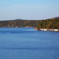
Blewett Falls Lake, body of water

Blewett Falls Lake is a reservoir in south-central North Carolina that spans between Wadesboro and Rockingham, covering about 2560 acres. The lake holds roughly 34 miles of shoreline when full and supports populations of catfish, crappie, bass, walleye, and stripers.

The lake was created in 1912 when Blewett Falls Dam was completed on the Pee Dee River. The concrete and earth structure, about 77 feet (23 meters) tall and over 4100 feet (1250 meters) long, was built to generate electricity, control floods, and supply drinking water.

The lake became a focal point for the region after the dam's construction in 1912, shaping how people spend their leisure time here. Fishing for catfish at night is a local tradition that reflects how deeply connected the community is to this body of water.

Two free boat ramps are available: one near the dam on Boat Landing Road and another on Highway 109 near Wadesboro, both with paved parking. Fishing is possible from shore or small boats, with night fishing for catfish being popular, and nearby campsites offering lodging options for overnight stays.

The Blewett Falls Tailrace Fishing Area below the dam is a specialized spot where fish come to spawn, including American shad. The fishing platform in this area was closed for construction work with reopening expected in June 2025.

The community of curious travelers

AroundUs brings together thousands of curated places, local tips, and hidden gems, enriched daily by 60,000 contributors worldwide.

Start exploring
Location
GPS coordinates
34.98278,-79.87778
Latest update
February 9, 2026 08:22
Around this place
Rockingham Speedway
United States of America

Rockingham Speedway

24.4 km
Lake Tillery
United States of America

Lake Tillery

30.3 km
Town Creek Indian Mound
United States of America

Town Creek Indian Mound

22.8 km
Naval Health Clinic Charleston
United States of America

Naval Health Clinic Charleston

15.5 km
United States of America

Pee Dee National Wildlife Refuge

19.3 km
St. David's Episcopal Church and Cemetery
United States of America

St. David's Episcopal Church and Cemetery

32 km
Covington Plantation House
United States of America

Covington Plantation House

11.7 km
Rockingham County Courthouse
United States of America

Rockingham County Courthouse

10.7 km
Boggan-Hammond House and Alexander Little Wing
United States of America

Boggan-Hammond House and Alexander Little Wing

18.6 km
Pegues Place
United States of America

Pegues Place

20.5 km
Robert Smalls School
United States of America

Robert Smalls School

31.3 km
Alfred Dockery House
United States of America

Alfred Dockery House

6.6 km
Main Street Commercial Historic District
United States of America

Main Street Commercial Historic District

19.6 km
U. S. Post Office and Federal Building
United States of America

U. S. Post Office and Federal Building

10.9 km
Roberdel Mill No. 1 Company Store
United States of America

Roberdel Mill No. 1 Company Store

12.2 km
Cheraw Historic District
United States of America

Cheraw Historic District

31.8 km
Bank of Pee Dee Building
United States of America

Bank of Pee Dee Building

10.6 km
Wadesboro Downtown Historic District
United States of America

Wadesboro Downtown Historic District

18.3 km
Richmond County Courthouse
United States of America

Richmond County Courthouse

10.7 km
East Main Street Historic District (Chesterfield, South Carolina)
United States of America

East Main Street Historic District (Chesterfield, South Carolina)

33.3 km
Rockingham Historic District
United States of America

Rockingham Historic District

11.4 km
H. C. Watson House
United States of America

H. C. Watson House

10.7 km
Liberty Hill School
United States of America

Liberty Hill School

17.3 km
Manufacturers Building
United States of America

Manufacturers Building

10.7 km
United States Post Office
United States of America

United States Post Office

18.2 km
Mount Gilead Downtown Historic District
United States of America

Mount Gilead Downtown Historic District

28.2 km
Dr. Thomas E. Lucas House
United States of America

Dr. Thomas E. Lucas House

33.7 km
Discovery Place Kids-Rockingham
United States of America

Discovery Place Kids-Rockingham

10.7 km
Show the full map
« Blewett Falls Lake - body of water » is provided by Around Us (aroundus.com). Images and texts are derived from Wikimedia project under a Creative Commons license. You are allowed to copy, distribute, and modify copies of this page, under the conditions set by the license, as long as this note is clearly visible.

Discover hidden gems everywhere you go!

From secret cafés to breathtaking viewpoints, skip the crowded tourist spots and find places that match your style. Our app makes it easy with voice search, smart filtering, route optimization, and insider tips from travelers worldwide. Download now for the complete mobile experience.

Around Us App Screenshot

A unique approach to discovering new places

Le Figaro

All the places worth exploring

France Info

A tailor-made excursion in just a few clicks

20 Minutes

Around Us
Travel Guide & Maps
Download

Send to your phone

QR Code
1

Open the camera app on your mobile.

2

Point at the QR code with your camera. A notification will appear.

3

Tap the notification to open the link.