Enable Location

We need your location to show you interesting places around you

Discover nearby places

Find interesting locations and hidden gems around you

Precise directions

Get accurate directions and distances to places

Your location is never shared with other users. It's only used when you tap the location button.

Burnt Quarter

Log in to your account

Start exploring — it's free

Trusted by 63,149 travelers worldwide

Continue with Google
Continue with Apple
or

We will send you a code to connect

By continuing, you accept our Terms and Conditions and our Privacy Policy

Check your inbox

We've sent a pincode in your inbox. Please enter the code below.

Discussion Reviews 1 Photos
1.2k Popularity

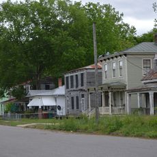
Burnt Quarter, human settlement in Virginia, United States of America

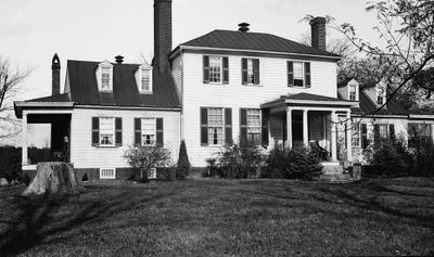
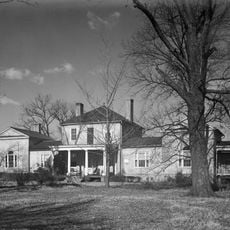
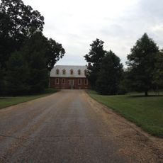
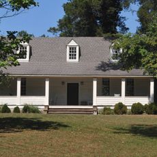
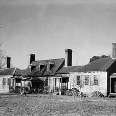
Burnt Quarter is a large house built around 1750 located in Dinwiddie County, Virginia. The main structure consists of a central section with a hipped roof and one-and-a-half-story wings on each side, expanded through multiple building phases.

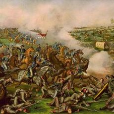
The estate was originally claimed by Robert Coleman in the late 1600s and later passed to the Gilliam family. During the Civil War, it served as Union headquarters in 1865 and was damaged during the Battle of Five Forks.

The name comes from a Revolutionary War incident when British forces burned grain storage buildings on the estate. The plantation served as a center of local economic and community life for generations.

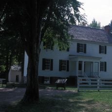
The property is privately owned today and not open for visitor access, though parts may be visible from nearby roads. A historical marker located four miles south of the house provides information about the site's history.

Portraits in the parlor were slashed by Union soldiers during the battle and deliberately left unrepaired by the family, preserving the visible wounds of war. These scars remain visible in the house's walls today.

The community of curious travelers

AroundUs brings together thousands of curated places, local tips, and hidden gems, enriched daily by 60,000 contributors worldwide.

Start exploring
Location
GPS coordinates
37.13860,-77.62500
Latest update
February 9, 2026 07:44
Around this place
Pamplin Historical Park
United States of America

Pamplin Historical Park

13.8 km
United States of America

Poplar Grove National Cemetery

17.6 km
Five Forks Battlefield
United States of America

Five Forks Battlefield

1.1 km
Gillfield Baptist Church
United States of America

Gillfield Baptist Church

21.5 km
Battersea
United States of America

Battersea

19.9 km
Dinwiddie County Court House
United States of America

Dinwiddie County Court House

7.6 km
Azurest South
United States of America

Azurest South

21.5 km
Thomas Wallace House
United States of America

Thomas Wallace House

21.6 km
Petersburg Breakthrough Battlefield
United States of America

Petersburg Breakthrough Battlefield

14.4 km
Commerce Street Industrial Historic District
United States of America

Commerce Street Industrial Historic District

20.4 km
Folly Castle Historic District
United States of America

Folly Castle Historic District

21.4 km
Mayfield Cottage
United States of America

Mayfield Cottage

17.8 km
Lee Memorial Park
United States of America

Lee Memorial Park

20.5 km
Montrose
United States of America

Montrose

19.9 km
Sutherland House
United States of America

Sutherland House

21.4 km
Zehmer Farm
United States of America

Zehmer Farm

19.5 km
Central State Hospital Chapel
United States of America

Central State Hospital Chapel

17.1 km
William McKenney House
United States of America

William McKenney House

21.2 km
Wales
United States of America

Wales

11.8 km
Atlantic Coast Line Railroad Commercial and Industrial Historic District
United States of America

Atlantic Coast Line Railroad Commercial and Industrial Historic District

21.6 km
Stewart-Hinton House
United States of America

Stewart-Hinton House

21.5 km
North Battersea-Pride's Field Historic District
United States of America

North Battersea-Pride's Field Historic District

20.7 km
United States of America

Perkins Pond

18.7 km
Ettrick-Matoaca Library
United States of America

Ettrick-Matoaca Library

19.1 km
Virginia Trunk & Bag Company
United States of America

Virginia Trunk & Bag Company

21.2 km
United States of America

Country Club of Petersburg

20.9 km
United States of America

Dogwood Trace Golf Course

21 km
United States of America

Work of art, sculpture

13.8 km
Show the full map
Reviews
Share your experience

No review yet

Discussions
Start a discussion...

No discussion yet

« Burnt Quarter - human settlement in Virginia, United States of America » is provided by Around Us (aroundus.com). Images and texts are derived from Wikimedia project under a Creative Commons license. You are allowed to copy, distribute, and modify copies of this page, under the conditions set by the license, as long as this note is clearly visible.

Discover hidden gems everywhere you go!

From secret cafés to breathtaking viewpoints, skip the crowded tourist spots and find places that match your style. Our app makes it easy with voice search, smart filtering, route optimization, and insider tips from travelers worldwide. Download now for the complete mobile experience.

Around Us App Screenshot

A unique approach to discovering new places

Le Figaro

All the places worth exploring

France Info

A tailor-made excursion in just a few clicks

20 Minutes

Around Us
Travel Guide & Maps
Download

Send to your phone

QR Code
1

Open the camera app on your mobile.

2

Point at the QR code with your camera. A notification will appear.

3

Tap the notification to open the link.