Enable Location

We need your location to show you interesting places around you

Discover nearby places

Find interesting locations and hidden gems around you

Precise directions

Get accurate directions and distances to places

Your location is never shared with other users. It's only used when you tap the location button.

Red Ball Garage

Log in to your account

Start exploring — it's free

Trusted by 61,343 travelers worldwide

Continue with Google
Continue with Apple
or

We will send you a code to connect

By continuing, you accept our Terms and Conditions and our Privacy Policy

Check your inbox

We've sent a pincode in your inbox. Please enter the code below.

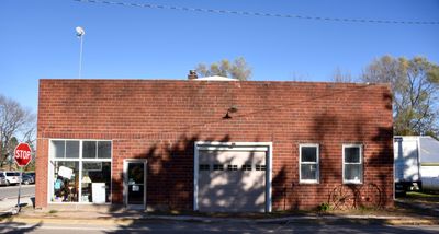
Red Ball Garage, Historic automotive building in Swedesburg, Iowa, US

Description

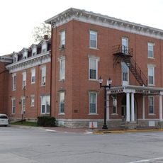
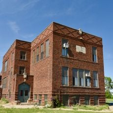
The Red Ball Garage is a brick structure at the intersection of former Military Road and U.S. Route 218 in Swedesburg, Iowa, a two-story building from 1929 with classic design features. The structure shows typical features of automotive service stations from the interwar period with solid masonry walls and large openings for vehicle access.

History

The site began as a blacksmith shop in 1870, before the current brick building was erected in 1929. It served as a Studebaker dealership from 1944 to 1966 and was added to the National Register of Historic Places in 1999.

Culture

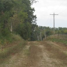
The name refers to the Red Ball Route, a highway system from the early 1900s that connected Minneapolis-St. Paul to St. Louis and was marked by red signs. The building sits at a historically important traffic intersection and recalls the role this route played in regional movement.

Practical

The building is maintained by a local museum and can be viewed from the outside, with the location on a main street making it easy to find. The best time to visit is during warmer months when the area is more accessible.

Did you know?

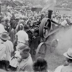
Before paved roads, the building helped rescue wagons and buggies trapped in the swampy terrain surrounding the former Military Road. This practical function shows how essential such workshops were before modern roads connected the region.

Location
GPS coordinates
41.10536,-91.54450
Latest update
December 12, 2025 14:26

AroundUs brings together thousands of curated places, local tips, and hidden gems, enriched daily by 60,000 contributors worldwide. Discover all places nearby (Wayne Township).

Around this place
United States of America

Old Thresher's Reunion

16.7 km
Union Block
United States of America

Union Block

15.6 km
Harlan-Lincoln House
United States of America

Harlan-Lincoln House

14.9 km
Masonic Temple Theater
United States of America

Masonic Temple Theater

15.4 km
Harlan House Hotel
United States of America

Harlan House Hotel

15.4 km
Midwest Old Threshers Heritage Museums & Business Office
United States of America

Midwest Old Threshers Heritage Museums & Business Office

16.8 km
New Sweden Chapel
United States of America

New Sweden Chapel

21.7 km
Washington County Courthouse
United States of America

Washington County Courthouse

19.7 km
Swedish Evangelical Lutheran Church
United States of America

Swedish Evangelical Lutheran Church

66 m
Gipple's Quarry Bridge
United States of America

Gipple's Quarry Bridge

15.9 km
Henry Ambler House
United States of America

Henry Ambler House

15 km
Pleasant Lawn School Historic District
United States of America

Pleasant Lawn School Historic District

10.6 km
Benjamin Chapel and Richwoods Cemetery
United States of America

Benjamin Chapel and Richwoods Cemetery

10.4 km
Henry County Courthouse
United States of America

Henry County Courthouse

15.7 km
Old Main
United States of America

Old Main

14.5 km
Charles E. Hult House, Summer Kitchen and Wood Shed
United States of America

Charles E. Hult House, Summer Kitchen and Wood Shed

137 m
Dr. J.O. and Catherine Ball House
United States of America

Dr. J.O. and Catherine Ball House

15 km
Brazelton House
United States of America

Brazelton House

15.1 km
Former Mount Pleasant Public Library
United States of America

Former Mount Pleasant Public Library

15.3 km
County Line Bridge
United States of America

County Line Bridge

18.7 km
George and Margaret Cooper House
United States of America

George and Margaret Cooper House

15.5 km
Second Baptist Church
United States of America

Second Baptist Church

15.1 km
G. W. S. Allen House
United States of America

G. W. S. Allen House

15.2 km
Oakland Mills Bridge
United States of America

Oakland Mills Bridge

19.9 km
John Hultquist House
United States of America

John Hultquist House

137 m
Mount Pleasant City Hall
United States of America

Mount Pleasant City Hall

15.5 km
Camp Harlan-Camp McKean Historic District
United States of America

Camp Harlan-Camp McKean Historic District

14.3 km
Swedesburg Historic Commercial District
United States of America

Swedesburg Historic Commercial District

104 m
Show the full map
« Red Ball Garage - Historic automotive building in Swedesburg, Iowa, US » is provided by Around Us (aroundus.com). Images and texts are derived from Wikimedia project under a Creative Commons license. You are allowed to copy, distribute, and modify copies of this page, under the conditions set by the license, as long as this note is clearly visible.

Discover hidden gems everywhere you go!

From secret cafés to breathtaking viewpoints, skip the crowded tourist spots and find places that match your style. Our app makes it easy with voice search, smart filtering, route optimization, and insider tips from travelers worldwide. Download now for the complete mobile experience.

Around Us App Screenshot

A unique approach to discovering new places

Le Figaro

All the places worth exploring

France Info

A tailor-made excursion in just a few clicks

20 Minutes

Around Us
Travel Guide & Maps
Download

Send to your phone

QR Code
1

Open the camera app on your mobile.

2

Point at the QR code with your camera. A notification will appear.

3

Tap the notification to open the link.