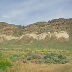
Jewel Creek Protected Area, protected area in British Columbia, Canada
Location: Thompson-Nicola Regional District
GPS coordinates: 50.91417,-121.07278
Latest update: November 21, 2025 07:27
McAbee Fossil Beds
13.9 km
Elephant Hill Provincial Park
22.9 km
Juniper Beach Provincial Park
14.3 km
Steelhead Provincial Park
23 km
Arrowstone Provincial Park
14.1 km
Castle Rock Hoodoos Provincial Park
25.5 km
Tunkwa Provincial Park
35.3 km
Painted Bluffs Provincial Park
26 km
Walhachin Oxbows Provincial Park
20.8 km
Harry Lake Aspen Provincial Park
35.7 km
Mount Savona Provincial Park
31.1 km
Deadman Falls
30.2 km
Tobiano
32.7 km
Loon Lake Provincial Park
24.9 km
Six Mile Hill Protected Area
30.7 km
Painted Bluffs
25.5 km
Tobiano Golf Course
33 km
Historic Hat Creek Ranch
23.9 km
Historic Hat Creek Ranch
23.8 km
Wabco 50T Haulpak Mining Truck
26.1 km
Ashcroft Opera House
25.9 km
Scenic viewpoint
30.3 km
Scenic viewpoint
30.4 km
Scenic viewpoint
24.9 km
Scenic viewpoint
28.9 km
Scenic viewpoint
29.3 km
Scenic viewpoint
29.3 km
Deadman Falls
30.2 kmReviews
Visited this place? Tap the stars to rate it and share your experience / photos with the community! Try now! You can cancel it anytime.
Discover hidden gems everywhere you go!
From secret cafés to breathtaking viewpoints, skip the crowded tourist spots and find places that match your style. Our app makes it easy with voice search, smart filtering, route optimization, and insider tips from travelers worldwide. Download now for the complete mobile experience.

A unique approach to discovering new places❞
— Le Figaro
All the places worth exploring❞
— France Info
A tailor-made excursion in just a few clicks❞
— 20 Minutes