Numahta, waterfall in British Columbia, Canada
Location: British Columbia
GPS coordinates: 49.00055,-124.99583
Latest update: November 24, 2023 23:42
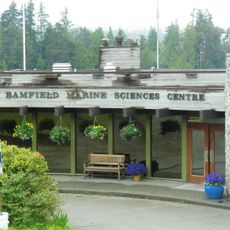
Bamfield Marine Sciences Centre
21 km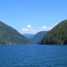
Alberni Inlet
16 km
Broughton Peaks
16.8 km
Baeria Rocks Ecological Reserve
12.8 km
Foucault Bluff
13.1 km
Upper Falls
13.7 km
Sarita Falls
12.3 km
Saach'akwat'a
885 m
T'iitskakis
17.1 km
Wihat'a
13 km
Yaashitquo-a
10.1 km
Shitlthmaq-is
11.9 km
Kookswees
11.9 km
Hiina'is
18.5 km
Tl'itsnit
11.2 km
K'oxsinqii
7.6 km
Hoo-ii
22.1 km
Ots'oo-a
21.3 km
Kiikiixink'ok
12.1 km
Tl'isnachis
11.3 km
Maht'ii'as
11.3 km
Klit-kle-mah-ah
5.4 km
Cha cha tsi tsi us
9.5 km
Thunderbird's Nest (T'iitsk'in Paawats) Protected Area
10.2 km
Waterfall
20.8 km
Waterfall
12.2 km
Waterfall
21.3 km
Waterfall
12.2 kmReviews
Visited this place? Tap the stars to rate it and share your experience / photos with the community! Try now! You can cancel it anytime.
Discover hidden gems everywhere you go!
From secret cafés to breathtaking viewpoints, skip the crowded tourist spots and find places that match your style. Our app makes it easy with voice search, smart filtering, route optimization, and insider tips from travelers worldwide. Download now for the complete mobile experience.

A unique approach to discovering new places❞
— Le Figaro
All the places worth exploring❞
— France Info
A tailor-made excursion in just a few clicks❞
— 20 Minutes